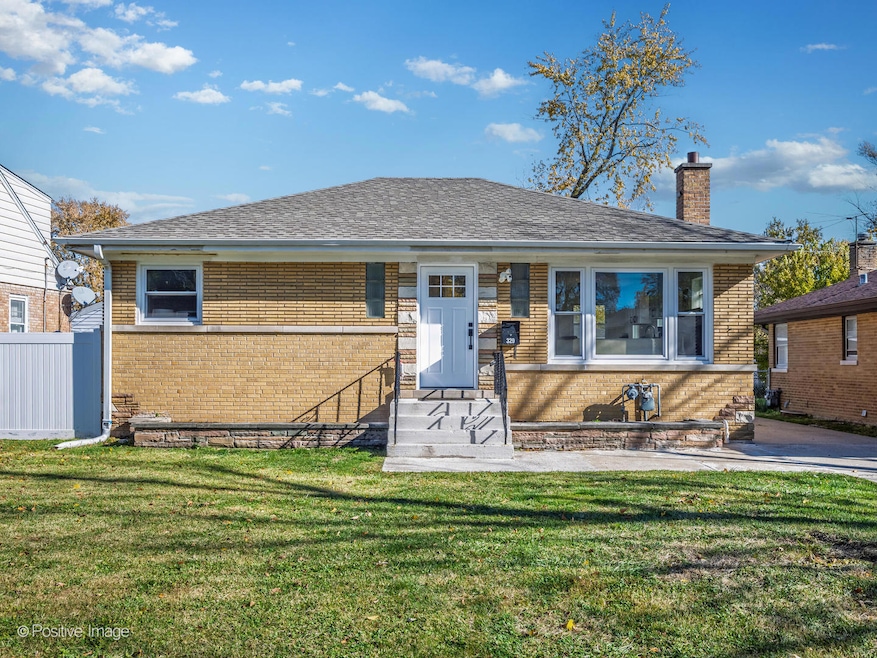
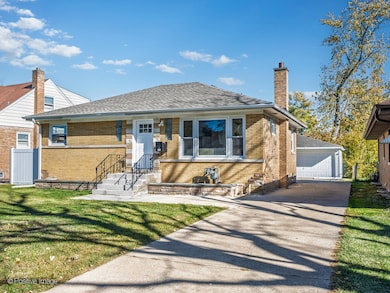
329 High Ridge Rd Hillside, IL 60162
Estimated payment $2,370/month
Highlights
- Popular Property
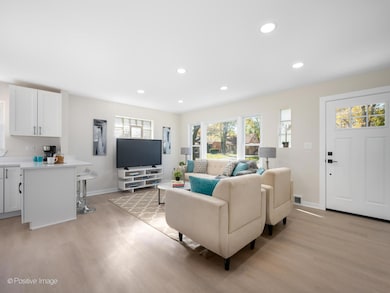
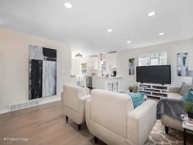
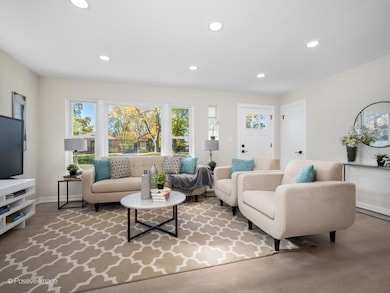
- Living Room
- Laundry Room
- Home Office
- Recessed Lighting
- 4-minute walk to Thiele Park
About This Home
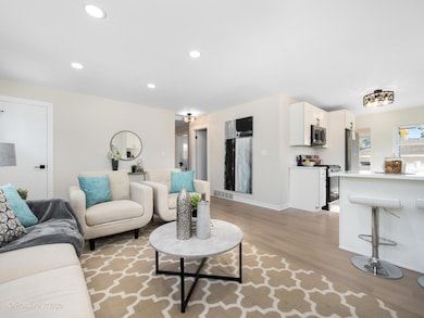
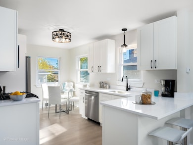
Fully renovated brick ranch - turnkey perfection inside and out! This beautifully updated 5-bedroom, 2-bath home offers the perfect blend of modern comfort and timeless charm. Step inside to a bright, open-concept living space featuring recessed lighting, large picture windows, and updated finishes throughout. Features include a modern kitchen with white shaker-style cabinetry, quartz countertops, all new stainless steel appliances, breakfast bar eating, and a cozy eat-in nook overlooking the backyard, perfect for casual mornings. The main level includes 3 spacious bedrooms and a fully updated bath with new tile and sleek fixtures. Downstairs, the fully finished lower level offers exceptional additional living space - a large family room with space for an office, 2 bedrooms, and a stylish full bath with designer tile and matte-black finishes. Outside, enjoy a low-maintenance yard and expansive patio area, ideal for outdoor dining and entertaining. Located on a quiet residential street close to parks, schools, shopping, and major expressways, this home delivers incredible value, convenience, and style - a rare find! Agent owned/interest.
Listing Agent
Jameson Sotheby's International Realty Brokerage Phone: (847) 736-6845 License #475192552 Listed on: 11/10/2025

Co-Listing Agent
Jameson Sotheby's Intl Realty Brokerage Phone: (847) 736-6845 License #475112796
Home Details
Home Type
- Single Family
Est. Annual Taxes
- $6,335
Year Built
- Built in 1954 | Remodeled in 2025
Lot Details
- Lot Dimensions are 50x130
Parking
- 2 Car Garage
- Driveway
- Parking Included in Price
Home Design
- Step Ranch
- Brick Exterior Construction
- Asphalt Roof
- Concrete Perimeter Foundation
Interior Spaces
- 1.5-Story Property
- Recessed Lighting
- Family Room
- Living Room
- Dining Room
- Home Office
- Storage Room
Kitchen
- Range
- Microwave
Bedrooms and Bathrooms
- 5 Bedrooms
- 5 Potential Bedrooms
- 2 Full Bathrooms
Laundry
- Laundry Room
- Dryer
- Washer
Basement
- Basement Fills Entire Space Under The House
- Finished Basement Bathroom
Schools
- Hillside Elementary School
Utilities
- Forced Air Heating and Cooling System
- Heating System Uses Natural Gas
- Lake Michigan Water
Map
Home Values in the Area
Average Home Value in this Area
Tax History
| Year | Tax Paid | Tax Assessment Tax Assessment Total Assessment is a certain percentage of the fair market value that is determined by local assessors to be the total taxable value of land and additions on the property. | Land | Improvement |
|---|---|---|---|---|
| 2024 | $6,335 | $21,000 | $3,575 | $17,425 |
| 2023 | $5,765 | $21,000 | $3,575 | $17,425 |
| 2022 | $5,765 | $18,034 | $3,088 | $14,946 |
| 2021 | $5,678 | $18,033 | $3,087 | $14,946 |
| 2020 | $5,603 | $18,033 | $3,087 | $14,946 |
| 2019 | $4,152 | $13,783 | $2,762 | $11,021 |
| 2018 | $4,032 | $13,783 | $2,762 | $11,021 |
| 2017 | $3,897 | $13,783 | $2,762 | $11,021 |
| 2016 | $3,597 | $11,902 | $2,437 | $9,465 |
| 2015 | $3,434 | $11,902 | $2,437 | $9,465 |
| 2014 | $3,367 | $11,902 | $2,437 | $9,465 |
| 2013 | $4,580 | $13,886 | $2,437 | $11,449 |
Property History
| Date | Event | Price | List to Sale | Price per Sq Ft |
|---|---|---|---|---|
| 11/20/2025 11/20/25 | Pending | -- | -- | -- |
| 11/10/2025 11/10/25 | For Sale | $349,900 | -- | -- |
Purchase History
| Date | Type | Sale Price | Title Company |
|---|---|---|---|
| Deed | $227,000 | Dukane Title Insurance Co | |
| Deed | -- | -- |
Mortgage History
| Date | Status | Loan Amount | Loan Type |
|---|---|---|---|
| Open | $181,600 | Fannie Mae Freddie Mac |
Source: Midwest Real Estate Data (MRED)
MLS Number: 12515322
APN: 15-17-104-005-0000
Disclaimer: Certain information contained herein is derived from information provided by parties other than Homes.com. All information provided is deemed reliable, but is not guaranteed to be accurate and should be independently verified.
![]() Based on information submitted to the MLS GRID. All data is obtained from various sources and may not have been verified by broker or MLS GRID. Supplied Open House Information is subject to change without notice. All information should be independently reviewed and verified for accuracy. Properties may or may not be listed by the office/agent presenting the information. Some IDX listings have been excluded from this website.
Based on information submitted to the MLS GRID. All data is obtained from various sources and may not have been verified by broker or MLS GRID. Supplied Open House Information is subject to change without notice. All information should be independently reviewed and verified for accuracy. Properties may or may not be listed by the office/agent presenting the information. Some IDX listings have been excluded from this website.
The Digital Millennium Copyright Act of 1998, 17 U.S.C. § 512 (the “DMCA”) provides recourse for copyright owners who believe that material appearing on the Internet infringes their rights under U.S. copyright law. If you believe in good faith that any content or material made available in connection with our website or services infringes your copyright, you (or your agent) may send us a notice requesting that the content or material be removed, or access to it blocked.
Notices must be sent in writing by email to DMCAnotice@MLSGrid.com.
The DMCA requires that your notice of alleged copyright infringement include the following information:
(1) description of the copyrighted work that is the subject of claimed infringement;
(2) description of the alleged infringing content and information sufficient to permit us to locate the content;
(3) contact information for you, including your address, telephone number and email address;
(4) a statement by you that you have a good faith belief that the content in the manner complained of is not authorized by the copyright owner, or its agent, or by the operation of any law;
(5) a statement by you, signed under penalty of perjury, that the information in the notification is accurate and that you have the authority to enforce the copyrights that are claimed to be infringed; and
(6) a physical or electronic signature of the copyright owner or a person authorized to act on the copyright owner’s behalf. Failure to include all of the above information may result in the delay of the processing of your complaint.
- 313 Iroquois Rd
- 4718 Butterfield Rd
- 334 Maple Ln
- 502 Clayton Rd
- 514 Iroquois Rd
- 520 N Wolf Rd Unit 301
- 439 N Elm St
- 533 50th Ave
- 529 49th Ave
- 768 N Rohde Ave
- 408 51st Ave
- 540 47th Ave
- 600 N Irving Ave
- 1509 Morris Ave
- 630 E End Ave
- 2012 N Taft Ave
- 543 Geneva Ave Unit 104A
- 5509 Bohlander Ave
- 5628 W Hawthorne Ave
- 1429 N Wolf Rd