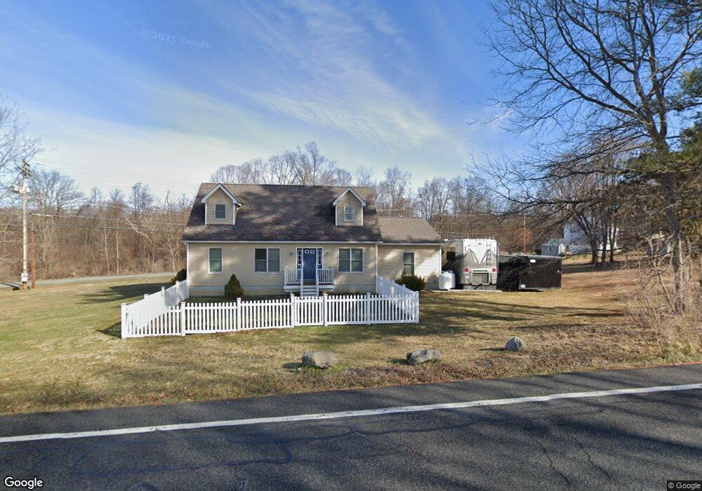
329 Maybrook Rd Campbell Hall, NY 10916
Estimated Value: $501,059 - $549,000
2
Beds
1
Bath
1,900
Sq Ft
$276/Sq Ft
Est. Value
About This Home
This home is located at 329 Maybrook Rd, Campbell Hall, NY 10916 and is currently estimated at $524,015, approximately $275 per square foot. 329 Maybrook Rd is a home located in Orange County with nearby schools including Valley Central High School.
Ownership History
Date
Name
Owned For
Owner Type
Purchase Details
Closed on
May 1, 2017
Sold by
Conroy Theodore J Ttee
Bought by
Fagnano Carrie
Current Estimated Value
Home Financials for this Owner
Home Financials are based on the most recent Mortgage that was taken out on this home.
Original Mortgage
$237,500
Outstanding Balance
$197,727
Interest Rate
4.14%
Mortgage Type
Purchase Money Mortgage
Estimated Equity
$326,288
Purchase Details
Closed on
Oct 24, 2016
Sold by
Conroy Theodore J
Bought by
Theodore J Conroy Liv Tr
Purchase Details
Closed on
Dec 2, 2011
Sold by
Treptow Jean
Bought by
Conroy Theodore
Create a Home Valuation Report for This Property
The Home Valuation Report is an in-depth analysis detailing your home's value as well as a comparison with similar homes in the area
Home Values in the Area
Average Home Value in this Area
Purchase History
| Date | Buyer | Sale Price | Title Company |
|---|---|---|---|
| Fagnano Carrie | $250,000 | Lisa Felicissimo | |
| Theodore J Conroy Liv Tr | -- | Richard J. Shapiro | |
| Conroy Theodore | $25,000 | Michael Blustein |
Source: Public Records
Mortgage History
| Date | Status | Borrower | Loan Amount |
|---|---|---|---|
| Open | Fagnano Carrie | $237,500 |
Source: Public Records
Tax History Compared to Growth
Tax History
| Year | Tax Paid | Tax Assessment Tax Assessment Total Assessment is a certain percentage of the fair market value that is determined by local assessors to be the total taxable value of land and additions on the property. | Land | Improvement |
|---|---|---|---|---|
| 2024 | $6,969 | $250,000 | $86,500 | $163,500 |
| 2023 | $6,969 | $250,000 | $86,500 | $163,500 |
| 2022 | $7,053 | $250,000 | $86,500 | $163,500 |
| 2021 | $7,029 | $250,000 | $86,500 | $163,500 |
| 2020 | $7,161 | $250,000 | $86,500 | $163,500 |
| 2019 | $7,264 | $250,000 | $86,500 | $163,500 |
| 2018 | $7,264 | $250,000 | $86,500 | $163,500 |
| 2017 | $7,391 | $250,000 | $86,500 | $163,500 |
| 2016 | $6,741 | $220,900 | $86,500 | $134,400 |
| 2015 | -- | $220,900 | $86,500 | $134,400 |
| 2014 | -- | $220,900 | $86,500 | $134,400 |
Source: Public Records
Map
Nearby Homes
- 0 Homestead Ave Unit ONEH6328393
- 101 Homestead Ave
- 108 Homestead Ave
- 119 Clark Place
- 311 Tower Ave
- 38 Jones Ln
- 0 Neelytown Rd Unit KEYH6313123
- 807 Abbey Ave
- 812 Tower Ave
- 2642 State Route 207
- 217 Blake Rd
- 204 Chrystal Dr
- 109 Indian Trail
- 111 Indian Trail
- 202 Blake Rd
- 108 Chrystal Dr
- 2323 State Route 207
- 4 Palmer Ct
- 16 Palmer Ct
- 205 Everett Place