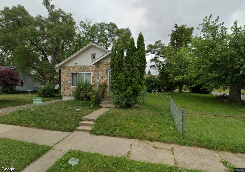
329 Osmun St Pontiac, MI 48342
Estimated Value: $100,098 - $178,000
3
Beds
1
Bath
983
Sq Ft
$134/Sq Ft
Est. Value
About This Home
This home is located at 329 Osmun St, Pontiac, MI 48342 and is currently estimated at $131,775, approximately $134 per square foot. 329 Osmun St is a home located in Oakland County with nearby schools including Walt Whitman Elementary School, Pontiac Middle School, and Pontiac High School.
Ownership History
Date
Name
Owned For
Owner Type
Purchase Details
Closed on
Mar 30, 1998
Sold by
Rtl Trust & Republic National Bank Of Ny
Bought by
Tillis Michelle
Current Estimated Value
Purchase Details
Closed on
Apr 28, 1997
Sold by
Tillis Michelle D
Bought by
Tillis Michelle D
Home Financials for this Owner
Home Financials are based on the most recent Mortgage that was taken out on this home.
Original Mortgage
$25,000
Interest Rate
7.94%
Create a Home Valuation Report for This Property
The Home Valuation Report is an in-depth analysis detailing your home's value as well as a comparison with similar homes in the area
Home Values in the Area
Average Home Value in this Area
Purchase History
| Date | Buyer | Sale Price | Title Company |
|---|---|---|---|
| Tillis Michelle | -- | -- | |
| Tillis Michelle D | -- | -- |
Source: Public Records
Mortgage History
| Date | Status | Borrower | Loan Amount |
|---|---|---|---|
| Previous Owner | Tillis Michelle D | $25,000 |
Source: Public Records
Tax History Compared to Growth
Tax History
| Year | Tax Paid | Tax Assessment Tax Assessment Total Assessment is a certain percentage of the fair market value that is determined by local assessors to be the total taxable value of land and additions on the property. | Land | Improvement |
|---|---|---|---|---|
| 2024 | $818 | $29,670 | $0 | $0 |
| 2023 | $780 | $25,790 | $0 | $0 |
| 2022 | $879 | $22,590 | $0 | $0 |
| 2021 | $1,385 | $20,040 | $0 | $0 |
| 2020 | $709 | $17,630 | $0 | $0 |
| 2019 | $800 | $15,210 | $0 | $0 |
| 2018 | $747 | $13,630 | $0 | $0 |
| 2017 | $504 | $13,000 | $0 | $0 |
| 2016 | $563 | $12,680 | $0 | $0 |
| 2015 | -- | $12,080 | $0 | $0 |
| 2014 | -- | $11,820 | $0 | $0 |
| 2011 | -- | $18,030 | $0 | $0 |
Source: Public Records
Map
Nearby Homes
- 187 Wall St
- 389 Osmun St
- 240 S Shirley St
- 397 S Jessie St
- 000 Wall St
- 317 Prospect St
- 328 Whittemore St
- 306 Whittemore St
- 176 S Francis Ave
- 472 S Jessie St
- 447 S Marshall St
- 440 Martin Luther King Junior Blvd S
- 465 S Marshall St
- 505 Auburn Ave
- 209 Ferry Ave
- 323 Ferry Ave
- 583 Going St
- 33 S Tasmania St
- 18 S Shirley St
- 455 Irwin Ave