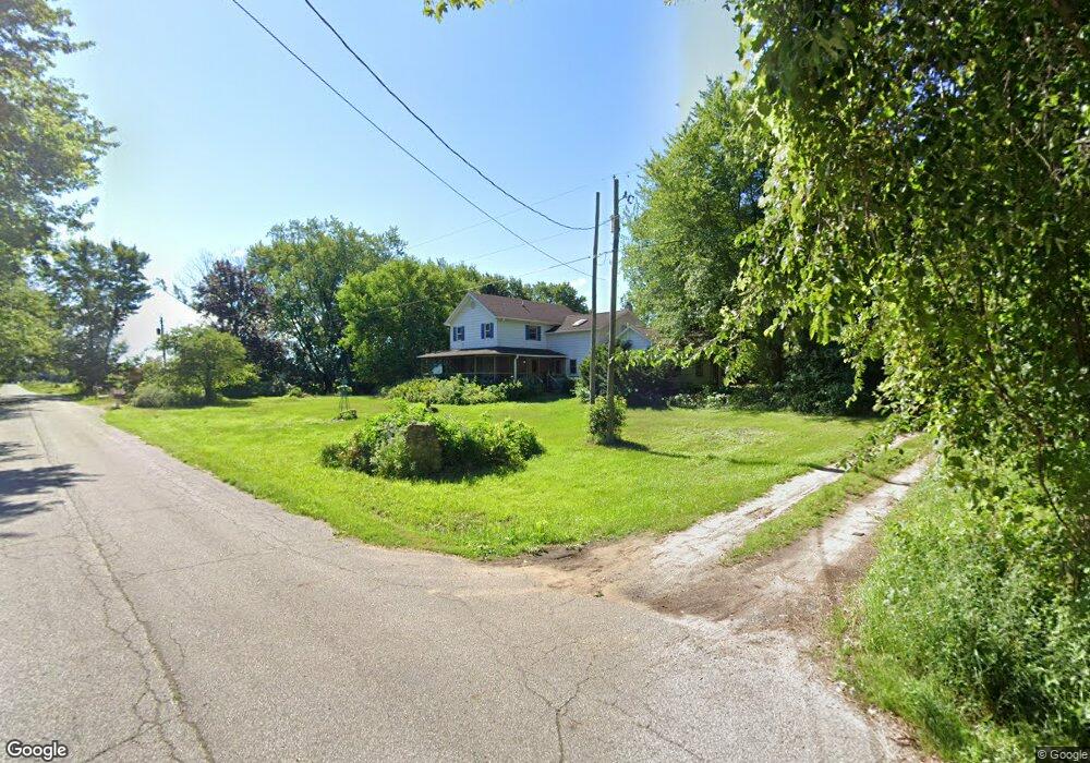
3292 W 700 N Michigan City, IN 46360
Estimated Value: $230,532 - $356,000
3
Beds
2
Baths
1,640
Sq Ft
$191/Sq Ft
Est. Value
About This Home
This home is located at 3292 W 700 N, Michigan City, IN 46360 and is currently estimated at $312,844, approximately $190 per square foot. 3292 W 700 N is a home located in LaPorte County with nearby schools including Springfield Elementary School, Martin T. Krueger Middle School, and Michigan City High School.
Ownership History
Date
Name
Owned For
Owner Type
Purchase Details
Closed on
Aug 23, 2019
Sold by
Bolton John F
Bought by
Bolton William E
Current Estimated Value
Home Financials for this Owner
Home Financials are based on the most recent Mortgage that was taken out on this home.
Original Mortgage
$192,375
Outstanding Balance
$168,485
Interest Rate
3.7%
Mortgage Type
New Conventional
Estimated Equity
$144,359
Purchase Details
Closed on
Nov 13, 2018
Sold by
Bolton Margaret S
Bought by
Bolton John F
Purchase Details
Closed on
Oct 22, 2018
Sold by
Bolton John F and Bolton Margaret S
Bought by
Bolton John F and Bolton Margaret
Create a Home Valuation Report for This Property
The Home Valuation Report is an in-depth analysis detailing your home's value as well as a comparison with similar homes in the area
Home Values in the Area
Average Home Value in this Area
Purchase History
| Date | Buyer | Sale Price | Title Company |
|---|---|---|---|
| Bolton William E | -- | None Available | |
| Bolton John F | -- | None Available | |
| Bolton John F | -- | None Available |
Source: Public Records
Mortgage History
| Date | Status | Borrower | Loan Amount |
|---|---|---|---|
| Open | Bolton William E | $192,375 |
Source: Public Records
Tax History Compared to Growth
Tax History
| Year | Tax Paid | Tax Assessment Tax Assessment Total Assessment is a certain percentage of the fair market value that is determined by local assessors to be the total taxable value of land and additions on the property. | Land | Improvement |
|---|---|---|---|---|
| 2024 | $747 | $112,400 | $37,200 | $75,200 |
| 2022 | $762 | $109,200 | $34,700 | $74,500 |
| 2021 | $697 | $103,300 | $34,100 | $69,200 |
| 2020 | $655 | $103,300 | $34,100 | $69,200 |
| 2019 | $751 | $102,000 | $29,900 | $72,100 |
| 2018 | $641 | $93,100 | $25,700 | $67,400 |
| 2017 | $562 | $85,400 | $25,800 | $59,600 |
| 2016 | $1,576 | $87,400 | $20,900 | $66,500 |
| 2014 | $415 | $76,900 | $20,900 | $56,000 |
Source: Public Records
Map
Nearby Homes
- 6862 NE Suburban Dr
- 7335 N 300 W
- N 450 W
- 0 W Us Hwy 20
- N Sr 39
- 1232 W 650 N
- 4852 W Us Highway 20
- 5034 N 400 W
- 5143 U S 20
- 00 Pawnee Trail
- 000 Pawnee Trail
- 0 Nicomus Path
- 3001 W 925 N
- 9851 N 500 W
- 5188 W Laxita Dr
- Integrity 1880 Plan at Woodland Ridge - Integrity
- Elements 2390 Plan at Woodland Ridge
- Elements 2090 Plan at Woodland Ridge
- Integrity 2060 Plan at Woodland Ridge - Integrity
- Elements 1870 Plan at Woodland Ridge
- 3274 W 700 N
- 3311 W 700 N
- 6945 NE Suburban Dr
- 3455 W 700 N
- 6928 NE Suburban Dr
- 6881 NE Suburban Dr
- 6908 NE Suburban Dr
- 6845 NE Suburban Dr
- 300 NW Suburban Dr
- 6845 NW Suburban Dr
- 7128 N 300 W
- 6846 NW Suburban Dr
- 6809 NW Suburban Dr
- 6809 NE Suburban Dr
- 3688 W 700 N
- 7144 N 300 W
- 3252 Garden Circle West S
- 3256 W South Garden Cir
- 7326 N Lilac Ln
- 7222 N 300 W