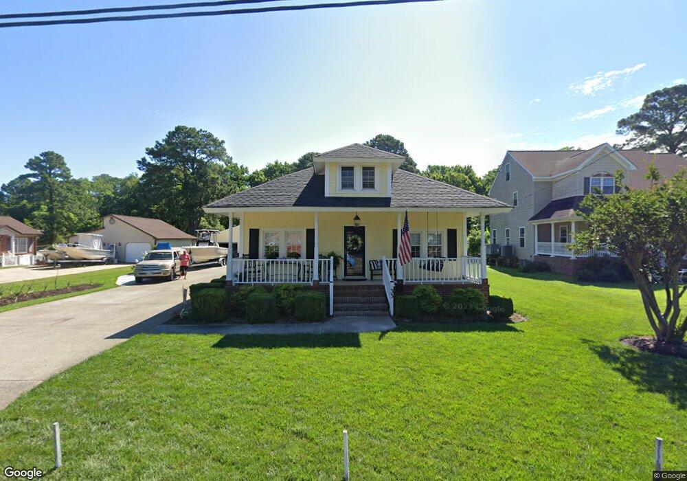
33 Bunting Ln Poquoson, VA 23662
Poquoson City Center NeighborhoodEstimated Value: $335,420 - $359,000
3
Beds
2
Baths
1,728
Sq Ft
$201/Sq Ft
Est. Value
About This Home
This home is located at 33 Bunting Ln, Poquoson, VA 23662 and is currently estimated at $347,105, approximately $200 per square foot. 33 Bunting Ln is a home located in Poquoson City with nearby schools including Emmanuel Lutheran School and Summit Christian Academy - Upper School.
Ownership History
Date
Name
Owned For
Owner Type
Purchase Details
Closed on
Aug 26, 2022
Sold by
Weston William Henry and Clark Bernard Il
Bought by
Lindsay Paul and Martin Shannon
Current Estimated Value
Purchase Details
Closed on
Feb 16, 2011
Sold by
Carroll Francis N
Bought by
Pauls John L and Mahanes Amanda N
Home Financials for this Owner
Home Financials are based on the most recent Mortgage that was taken out on this home.
Original Mortgage
$243,662
Interest Rate
4.5%
Mortgage Type
FHA
Create a Home Valuation Report for This Property
The Home Valuation Report is an in-depth analysis detailing your home's value as well as a comparison with similar homes in the area
Home Values in the Area
Average Home Value in this Area
Purchase History
| Date | Buyer | Sale Price | Title Company |
|---|---|---|---|
| Lindsay Paul | -- | None Listed On Document | |
| Pauls John L | $250,000 | -- |
Source: Public Records
Mortgage History
| Date | Status | Borrower | Loan Amount |
|---|---|---|---|
| Previous Owner | Pauls John L | $243,662 |
Source: Public Records
Tax History Compared to Growth
Tax History
| Year | Tax Paid | Tax Assessment Tax Assessment Total Assessment is a certain percentage of the fair market value that is determined by local assessors to be the total taxable value of land and additions on the property. | Land | Improvement |
|---|---|---|---|---|
| 2024 | $3,262 | $286,100 | $98,400 | $187,700 |
| 2023 | $3,176 | $286,100 | $98,400 | $187,700 |
| 2022 | $3,011 | $266,500 | $98,300 | $168,200 |
| 2021 | $3,011 | $266,500 | $98,300 | $168,200 |
| 2020 | -- | $247,400 | $98,300 | $149,100 |
| 2019 | -- | $247,400 | $98,300 | $149,100 |
| 2018 | -- | $244,500 | $98,300 | $146,200 |
| 2017 | -- | $216,400 | $98,300 | $118,100 |
| 2016 | -- | $216,400 | $98,300 | $118,100 |
| 2015 | -- | $213,200 | $102,400 | $110,800 |
| 2013 | -- | $213,200 | $102,400 | $110,800 |
Source: Public Records
Map
Nearby Homes
- 8.5AC Poquoson Ave
- 1020 Poquoson Ave
- 1020 Poquoson Ave Unit C
- 101 Oystermans Way
- 103 Oystermans Way
- 1158 Poquoson Ave
- 1159 Poquoson Ave
- 49 Church St
- 16 Lodge Rd
- 1216 Poquoson Ave
- 1267 Poquoson Ave
- 7 Dove Point Trail
- 5 Trinity Dr
- 114 Legacy Blvd
- 7 Quail Cove
- 1360 Poquoson Ave
- 10 Kathy Dr
- 208 Little Florida Rd
- 78 Ridge Rd
- 1.55ac Holloway Rd