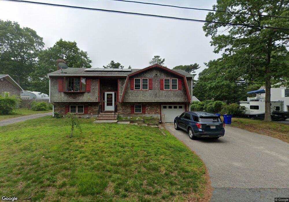
33 Catskill Rd Bourne, MA 2532
Buzzards Bay NeighborhoodEstimated Value: $606,000 - $670,000
3
Beds
3
Baths
2,100
Sq Ft
$306/Sq Ft
Est. Value
About This Home
This home is located at 33 Catskill Rd, Bourne, MA 2532 and is currently estimated at $642,695, approximately $306 per square foot. 33 Catskill Rd is a home located in Barnstable County with nearby schools including Bourne High School and St Margaret Regional School.
Ownership History
Date
Name
Owned For
Owner Type
Purchase Details
Closed on
Jul 15, 2022
Sold by
Griffin Matthew
Bought by
Santacqua Frank and Pontes Merrill
Current Estimated Value
Home Financials for this Owner
Home Financials are based on the most recent Mortgage that was taken out on this home.
Original Mortgage
$474,900
Outstanding Balance
$450,492
Interest Rate
5.09%
Mortgage Type
Purchase Money Mortgage
Estimated Equity
$192,203
Purchase Details
Closed on
Jul 11, 2019
Sold by
Figliolini Paul R and Figliolini Barbara L
Bought by
Griffin Matthew
Home Financials for this Owner
Home Financials are based on the most recent Mortgage that was taken out on this home.
Original Mortgage
$324,022
Interest Rate
3.5%
Mortgage Type
FHA
Purchase Details
Closed on
May 8, 2019
Sold by
Barbara E Mcneil Lt and Figliolini
Bought by
Figliolini Paul R
Purchase Details
Closed on
May 2, 2019
Sold by
Figliolini Paul R
Bought by
Figliolini Paul R and Figliolini Barbara L
Purchase Details
Closed on
Jun 22, 2011
Sold by
Mcneil Barbara E
Bought by
Barbara E Mcneil Lt and Mcneil
Purchase Details
Closed on
Aug 30, 1999
Sold by
Harrington Jeanette and Vitti Phillip M
Bought by
Mcneil William J and Mcneil Barbara E
Home Financials for this Owner
Home Financials are based on the most recent Mortgage that was taken out on this home.
Original Mortgage
$130,000
Interest Rate
7.53%
Mortgage Type
Purchase Money Mortgage
Create a Home Valuation Report for This Property
The Home Valuation Report is an in-depth analysis detailing your home's value as well as a comparison with similar homes in the area
Home Values in the Area
Average Home Value in this Area
Purchase History
| Date | Buyer | Sale Price | Title Company |
|---|---|---|---|
| Santacqua Frank | $499,900 | None Available | |
| Griffin Matthew | $330,000 | -- | |
| Figliolini Paul R | -- | -- | |
| Figliolini Paul R | -- | -- | |
| Barbara E Mcneil Lt | -- | -- | |
| Barbara E Mcneil Lt | -- | -- | |
| Barbara E Mcneil Lt | -- | -- | |
| Mcneil William J | $170,000 | -- | |
| Mcneil William J | $170,000 | -- |
Source: Public Records
Mortgage History
| Date | Status | Borrower | Loan Amount |
|---|---|---|---|
| Open | Santacqua Frank | $474,900 | |
| Previous Owner | Griffin Matthew | $324,022 | |
| Previous Owner | Mcneil William J | $130,000 |
Source: Public Records
Tax History
| Year | Tax Paid | Tax Assessment Tax Assessment Total Assessment is a certain percentage of the fair market value that is determined by local assessors to be the total taxable value of land and additions on the property. | Land | Improvement |
|---|---|---|---|---|
| 2025 | $4,077 | $522,000 | $195,600 | $326,400 |
| 2024 | $3,986 | $497,000 | $186,300 | $310,700 |
| 2023 | $3,836 | $435,400 | $164,900 | $270,500 |
| 2022 | $3,639 | $360,700 | $145,900 | $214,800 |
| 2021 | $3,537 | $328,400 | $132,800 | $195,600 |
| 2020 | $3,279 | $305,300 | $131,500 | $173,800 |
| 2019 | $3,107 | $295,600 | $131,500 | $164,100 |
| 2018 | $2,983 | $283,000 | $119,000 | $164,000 |
| 2017 | $2,885 | $280,100 | $117,900 | $162,200 |
| 2016 | $2,663 | $262,100 | $105,500 | $156,600 |
| 2015 | $2,639 | $262,100 | $105,500 | $156,600 |
Source: Public Records
Map
Nearby Homes
- 4 Van Bummel Rd
- 40-A Lafayette Ave
- 23 Alderberry Rd
- 46 Holt Rd Unit B
- 46 Holt Rd
- 48 Maple St
- 9 Hideaway Rd Unit F
- 92 Choctaw Dr
- 60 Bourne Neck Dr
- 13 Hideaway Village Unit G
- 58 Maple St
- 810 Head of The Bay Rd
- 60 Martin St
- 67 Algonquin St
- 3 Fairway Dr Unit F
- 29 Wenonah Rd
- 29 Wenonah Rd
- 11 Buzzards Bay Dr
- 3132 Cranberry Hwy Unit 59
- 304 Main St
Your Personal Tour Guide
Ask me questions while you tour the home.