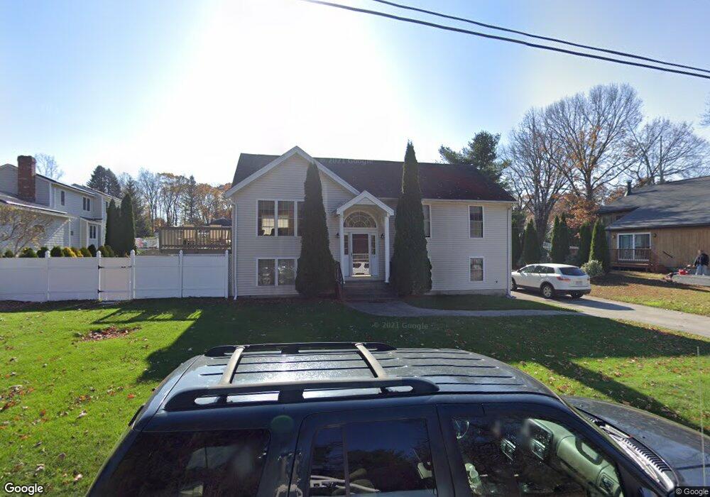
33 Dupuis Ave Worcester, MA 01604
Broadmeadow Brook NeighborhoodEstimated Value: $403,000 - $484,000
3
Beds
2
Baths
1,056
Sq Ft
$421/Sq Ft
Est. Value
About This Home
This home is located at 33 Dupuis Ave, Worcester, MA 01604 and is currently estimated at $444,216, approximately $420 per square foot. 33 Dupuis Ave is a home located in Worcester County with nearby schools including Jacob Hiatt Magnet School, Chandler Magnet, and Rice Square Elementary School.
Ownership History
Date
Name
Owned For
Owner Type
Purchase Details
Closed on
Feb 16, 2022
Sold by
Dumphy Kevin M and Dumphy Tami M
Bought by
Dumphy Kevin M
Current Estimated Value
Home Financials for this Owner
Home Financials are based on the most recent Mortgage that was taken out on this home.
Original Mortgage
$276,500
Outstanding Balance
$255,770
Interest Rate
3.55%
Mortgage Type
Purchase Money Mortgage
Estimated Equity
$188,446
Purchase Details
Closed on
Jun 30, 1997
Sold by
Highland North Corp
Bought by
Dumphy Kevin M and Dumphy Tamai M
Purchase Details
Closed on
Apr 14, 1997
Sold by
Mozynski Paul E and Mozynski Paula M
Bought by
Highland North Corp
Create a Home Valuation Report for This Property
The Home Valuation Report is an in-depth analysis detailing your home's value as well as a comparison with similar homes in the area
Home Values in the Area
Average Home Value in this Area
Purchase History
| Date | Buyer | Sale Price | Title Company |
|---|---|---|---|
| Dumphy Kevin M | $60,000 | None Available | |
| Dumphy Kevin M | $126,000 | -- | |
| Highland North Corp | $26,000 | -- |
Source: Public Records
Mortgage History
| Date | Status | Borrower | Loan Amount |
|---|---|---|---|
| Open | Dumphy Kevin M | $276,500 | |
| Previous Owner | Highland North Corp | $192,000 | |
| Previous Owner | Highland North Corp | $160,000 |
Source: Public Records
Tax History
| Year | Tax Paid | Tax Assessment Tax Assessment Total Assessment is a certain percentage of the fair market value that is determined by local assessors to be the total taxable value of land and additions on the property. | Land | Improvement |
|---|---|---|---|---|
| 2025 | $5,798 | $439,600 | $118,000 | $321,600 |
| 2024 | $5,639 | $410,100 | $118,000 | $292,100 |
| 2023 | $5,505 | $383,900 | $102,600 | $281,300 |
| 2022 | $4,857 | $319,300 | $82,100 | $237,200 |
| 2021 | $4,799 | $294,800 | $65,600 | $229,200 |
| 2020 | $4,578 | $269,300 | $65,700 | $203,600 |
| 2019 | $4,466 | $248,100 | $59,100 | $189,000 |
| 2018 | $4,485 | $237,200 | $59,100 | $178,100 |
| 2017 | $4,294 | $223,400 | $59,100 | $164,300 |
| 2016 | $4,246 | $206,000 | $43,100 | $162,900 |
| 2015 | $4,134 | $206,000 | $43,100 | $162,900 |
| 2014 | $4,025 | $206,000 | $43,100 | $162,900 |
Source: Public Records
Map
Nearby Homes
- 3 Julien Ave
- 16 Vincent Cir
- 266 Massasoit Rd
- 256 Massasoit Rd
- 259 Massasoit Rd
- 25 Stoneham Rd
- 330 Sunderland Rd Unit 80
- 330 Sunderland Rd Unit 69
- 9 Marissa Cir
- 37 Dane Ave
- 62 Allston Ave
- 340 Sunderland Rd Unit 28
- 464-466 Granite St
- 460-462 Granite St
- 460-466 Granite St
- 20 Brightwood Ave
- 83 Massasoit Rd
- 48 Gibbs St Unit 2-1B
- 47 Gibbs St
- 1260 Grafton St
Your Personal Tour Guide
Ask me questions while you tour the home.