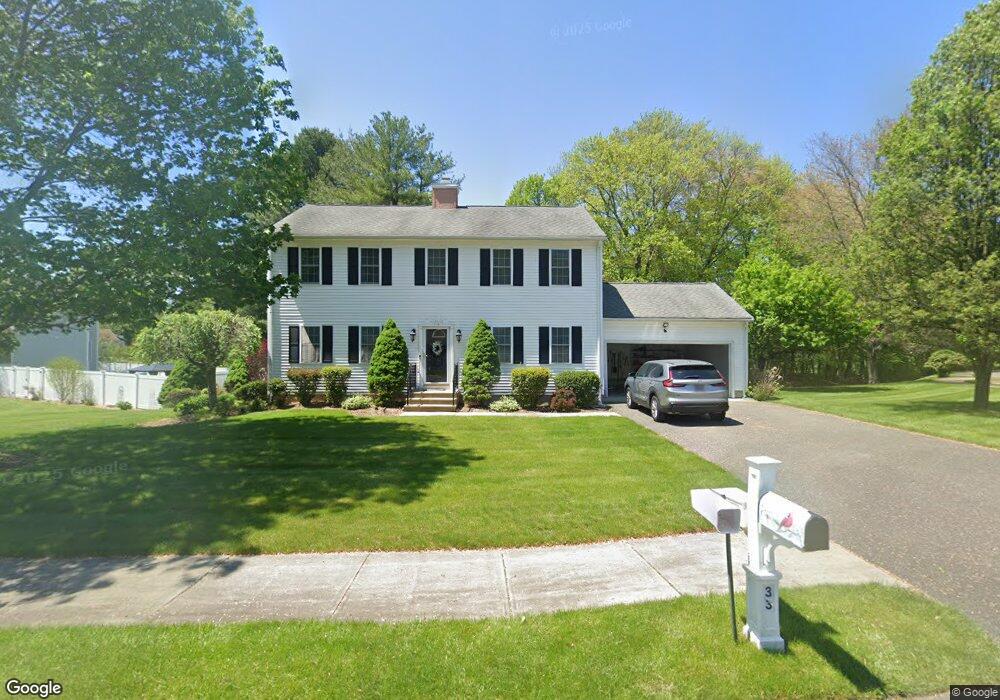
33 Family Ln Agawam, MA 01001
Estimated Value: $509,760 - $622,000
4
Beds
3
Baths
1,976
Sq Ft
$283/Sq Ft
Est. Value
About This Home
This home is located at 33 Family Ln, Agawam, MA 01001 and is currently estimated at $558,940, approximately $282 per square foot. 33 Family Ln is a home located in Hampden County with nearby schools including Agawam Junior High School and Agawam High School.
Ownership History
Date
Name
Owned For
Owner Type
Purchase Details
Closed on
Jan 27, 2012
Sold by
Spellacy Daniel W and Spellacy Janice R
Bought by
Spellacy Christopher W
Current Estimated Value
Purchase Details
Closed on
Oct 29, 2004
Sold by
Defronzo Morando and Defronzo Rosemary E
Bought by
Spellacy Daniel W and Spellacy Janice R
Home Financials for this Owner
Home Financials are based on the most recent Mortgage that was taken out on this home.
Original Mortgage
$309,600
Interest Rate
5.74%
Mortgage Type
Purchase Money Mortgage
Purchase Details
Closed on
Oct 12, 2000
Sold by
Fiore James W
Bought by
Defronzo Morando and Defronzo Rosemary E
Purchase Details
Closed on
Feb 15, 2000
Sold by
Russo Joseph T
Bought by
Fiore James W
Create a Home Valuation Report for This Property
The Home Valuation Report is an in-depth analysis detailing your home's value as well as a comparison with similar homes in the area
Home Values in the Area
Average Home Value in this Area
Purchase History
| Date | Buyer | Sale Price | Title Company |
|---|---|---|---|
| Spellacy Christopher W | -- | -- | |
| Spellacy Daniel W | $326,000 | -- | |
| Defronzo Morando | $204,900 | -- | |
| Fiore James W | $55,500 | -- |
Source: Public Records
Mortgage History
| Date | Status | Borrower | Loan Amount |
|---|---|---|---|
| Previous Owner | Fiore James W | $44,600 | |
| Previous Owner | Fiore James W | $50,000 | |
| Previous Owner | Spellacy Daniel W | $309,600 | |
| Previous Owner | Fiore James W | $200,000 |
Source: Public Records
Tax History Compared to Growth
Tax History
| Year | Tax Paid | Tax Assessment Tax Assessment Total Assessment is a certain percentage of the fair market value that is determined by local assessors to be the total taxable value of land and additions on the property. | Land | Improvement |
|---|---|---|---|---|
| 2025 | $6,502 | $444,100 | $130,400 | $313,700 |
| 2024 | $6,339 | $436,000 | $130,400 | $305,600 |
| 2023 | $6,295 | $398,900 | $117,600 | $281,300 |
| 2022 | $6,036 | $374,700 | $117,600 | $257,100 |
| 2021 | $5,631 | $335,200 | $100,100 | $235,100 |
| 2020 | $5,530 | $328,600 | $98,100 | $230,500 |
| 2019 | $5,341 | $320,800 | $95,300 | $225,500 |
| 2018 | $5,079 | $305,800 | $95,300 | $210,500 |
| 2017 | $4,842 | $296,900 | $95,300 | $201,600 |
| 2016 | $4,605 | $284,600 | $95,300 | $189,300 |
| 2015 | $4,423 | $281,000 | $95,300 | $185,700 |
Source: Public Records
Map
Nearby Homes
- 190 Mill St
- 73 Silver Lake Dr
- 712 Cooper St
- 354 Rowley St
- 0 Silver St
- 7 Castle Hill Rd Unit G
- 6 Castle Hill Rd Unit E
- 108 Franklin St
- 441 Silver St
- 267 Rowley St
- 4H Mapleviewlane Unit 4H
- 35 Birch Hill Rd
- 13 Castle Hills Rd Unit B
- 66 Sheri Ln Unit 66
- 15 B Castle Hills Rd Unit B
- 25 Damato Way
- 468 Springfield St
- 83 Harvey Johnson Dr
- 138 Suffield St
- 795 Main St