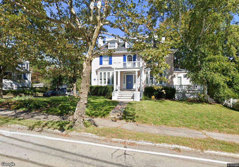
33 Gray St Arlington, MA 02476
Arlington Center NeighborhoodEstimated Value: $1,680,000 - $2,221,000
5
Beds
3
Baths
3,144
Sq Ft
$612/Sq Ft
Est. Value
About This Home
This home is located at 33 Gray St, Arlington, MA 02476 and is currently estimated at $1,923,010, approximately $611 per square foot. 33 Gray St is a home located in Middlesex County with nearby schools including Bishop Elementary School, Ottoson Middle School, and Arlington High School.
Ownership History
Date
Name
Owned For
Owner Type
Purchase Details
Closed on
Apr 17, 2020
Sold by
Lubar Kenneth M and Lubar Susan R
Bought by
Lubar Ft and Lubar
Current Estimated Value
Purchase Details
Closed on
Jan 7, 1999
Sold by
Duffy Richard A and Rodriguez Jose M
Bought by
Lubar Kenneth M and Lubar Susan R
Purchase Details
Closed on
Aug 30, 1993
Sold by
Smith Margaret
Bought by
Duffy Richard A and Rodriguez Jose M
Create a Home Valuation Report for This Property
The Home Valuation Report is an in-depth analysis detailing your home's value as well as a comparison with similar homes in the area
Home Values in the Area
Average Home Value in this Area
Purchase History
| Date | Buyer | Sale Price | Title Company |
|---|---|---|---|
| Lubar Ft | -- | None Available | |
| Lubar Kenneth M | $632,500 | -- | |
| Duffy Richard A | $286,000 | -- |
Source: Public Records
Mortgage History
| Date | Status | Borrower | Loan Amount |
|---|---|---|---|
| Previous Owner | Duffy Richard A | $290,000 | |
| Previous Owner | Duffy Richard A | $69,000 | |
| Closed | Duffy Richard A | $0 |
Source: Public Records
Tax History
| Year | Tax Paid | Tax Assessment Tax Assessment Total Assessment is a certain percentage of the fair market value that is determined by local assessors to be the total taxable value of land and additions on the property. | Land | Improvement |
|---|---|---|---|---|
| 2025 | $18,862 | $1,751,300 | $772,800 | $978,500 |
| 2024 | $17,443 | $1,647,100 | $744,700 | $902,400 |
| 2023 | $16,885 | $1,506,200 | $681,400 | $824,800 |
| 2022 | $15,745 | $1,378,700 | $632,300 | $746,400 |
| 2021 | $15,373 | $1,355,600 | $632,300 | $723,300 |
| 2020 | $14,992 | $1,355,500 | $632,300 | $723,200 |
| 2019 | $13,531 | $1,201,700 | $667,400 | $534,300 |
| 2018 | $12,434 | $1,025,100 | $491,800 | $533,300 |
| 2017 | $12,610 | $1,004,000 | $470,700 | $533,300 |
| 2016 | $12,402 | $968,900 | $435,600 | $533,300 |
| 2015 | $11,999 | $885,500 | $365,300 | $520,200 |
Source: Public Records
Map
Nearby Homes
- 93 Churchill Ave
- 23 Newman Way Unit 1
- 33 Lombard Rd
- 31 Brunswick Rd
- 115 Gloucester St
- 40 Pleasant St Unit 2
- 9 Venner Rd
- 21 Avon Place
- 315 Lake St
- 384 Brighton St
- 32 Colonial Dr
- 2 Bellevue Rd
- 16 Cheswick Rd
- 26-28 Alton St
- 14 Albermarle St Unit 14
- 27 Little Pond Rd
- 995 Massachusetts Ave Unit 105
- 995 Massachusetts Ave Unit 404
- 108 Radcliffe Rd
- 132 Warren St Unit B
Your Personal Tour Guide
Ask me questions while you tour the home.