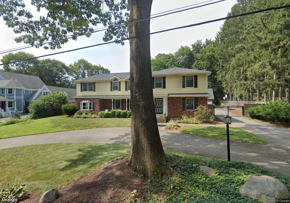
33 Massasoit Ave Sudbury, MA 01776
Estimated Value: $1,008,000 - $1,337,000
3
Beds
3
Baths
3,011
Sq Ft
$397/Sq Ft
Est. Value
About This Home
This home is located at 33 Massasoit Ave, Sudbury, MA 01776 and is currently estimated at $1,194,720, approximately $396 per square foot. 33 Massasoit Ave is a home located in Middlesex County with nearby schools including Israel Loring Elementary School, Ephraim Curtis Middle School, and Lincoln-Sudbury Regional High School.
Ownership History
Date
Name
Owned For
Owner Type
Purchase Details
Closed on
Jul 30, 1999
Sold by
Keenan Mark and Keenan Karen
Bought by
Immerman John D and Yee Laura
Current Estimated Value
Home Financials for this Owner
Home Financials are based on the most recent Mortgage that was taken out on this home.
Original Mortgage
$300,000
Outstanding Balance
$85,940
Interest Rate
7.61%
Mortgage Type
Purchase Money Mortgage
Estimated Equity
$1,108,780
Create a Home Valuation Report for This Property
The Home Valuation Report is an in-depth analysis detailing your home's value as well as a comparison with similar homes in the area
Home Values in the Area
Average Home Value in this Area
Purchase History
| Date | Buyer | Sale Price | Title Company |
|---|---|---|---|
| Immerman John D | $415,000 | -- |
Source: Public Records
Mortgage History
| Date | Status | Borrower | Loan Amount |
|---|---|---|---|
| Open | Immerman John D | $300,000 | |
| Previous Owner | Immerman John D | $225,000 |
Source: Public Records
Tax History Compared to Growth
Tax History
| Year | Tax Paid | Tax Assessment Tax Assessment Total Assessment is a certain percentage of the fair market value that is determined by local assessors to be the total taxable value of land and additions on the property. | Land | Improvement |
|---|---|---|---|---|
| 2025 | $13,743 | $938,700 | $398,800 | $539,900 |
| 2024 | $13,216 | $904,600 | $387,200 | $517,400 |
| 2023 | $12,485 | $791,700 | $358,500 | $433,200 |
| 2022 | $12,065 | $668,400 | $329,000 | $339,400 |
| 2021 | $11,622 | $617,200 | $329,000 | $288,200 |
| 2020 | $11,387 | $617,200 | $329,000 | $288,200 |
| 2019 | $11,054 | $617,200 | $329,000 | $288,200 |
| 2018 | $11,040 | $615,700 | $350,800 | $264,900 |
| 2017 | $10,578 | $596,300 | $333,700 | $262,600 |
| 2016 | $10,263 | $576,600 | $321,000 | $255,600 |
| 2015 | $9,851 | $559,700 | $308,700 | $251,000 |
| 2014 | $9,578 | $531,200 | $299,600 | $231,600 |
Source: Public Records
Map
Nearby Homes
- 23 Massasoit Ave
- 36 Concord Rd
- 94 Goodmans Hill Rd
- 1011 Boston Post Rd
- 216 Landham Rd
- 270 Old Lancaster Rd
- 89 Bridle Path
- 6 Old County Rd Unit 16
- 24 Woodland Rd
- 128 Nobscot Rd
- 25 Bridle Path
- 84 Hopestill Brown Rd
- 7 Adams Rd
- 0 Wagonwheel Rd
- 63 Landham Rd
- 23 Cider Mill Rd
- 0 Robbins Rd
- 30 Nobscot Rd Unit 14
- 12 Hickory Rd
- 91 Eaton Rd W
- 29 Massasoit Ave
- 39 Massasoit Ave
- 28 Church St
- 40 Massasoit Ave
- 32 Massasoit Ave
- 45 Massasoit Ave
- 30 Church St
- 42 Massasoit Ave
- 24 Church St
- 11 Bradley Place
- 14 Bradley Place
- 54 King Philip Rd
- 46 Massasoit Ave
- 34 Church St
- 20 Church St
- 48 King Philip Rd
- 19 Church St
- 49 Massasoit Ave
- 11 Allen Place
- 7 Bradley Place