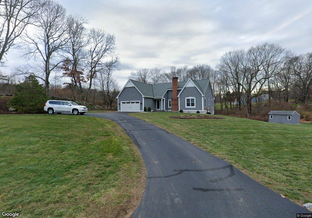
33 N Farms Rd Coventry, CT 06238
Estimated Value: $501,000 - $553,000
3
Beds
2
Baths
1,789
Sq Ft
$290/Sq Ft
Est. Value
About This Home
This home is located at 33 N Farms Rd, Coventry, CT 06238 and is currently estimated at $518,901, approximately $290 per square foot. 33 N Farms Rd is a home located in Tolland County with nearby schools including Coventry Grammar School, George Hersey Robertson School, and Capt. Nathan Hale School.
Ownership History
Date
Name
Owned For
Owner Type
Purchase Details
Closed on
Aug 30, 2001
Sold by
Shepard James and Shepard Mary
Bought by
Medzela Jack and Medzela Marjorie
Current Estimated Value
Purchase Details
Closed on
Jul 8, 1997
Sold by
Barr Scott and Barr Lisa
Bought by
Shepard James and Shepard Mary
Purchase Details
Closed on
Jun 12, 1992
Sold by
Paxton Dev Group
Bought by
Barr Scott and Barr Lisa
Create a Home Valuation Report for This Property
The Home Valuation Report is an in-depth analysis detailing your home's value as well as a comparison with similar homes in the area
Home Values in the Area
Average Home Value in this Area
Purchase History
| Date | Buyer | Sale Price | Title Company |
|---|---|---|---|
| Medzela Jack | $260,000 | -- | |
| Shepard James | $43,000 | -- | |
| Barr Scott | $54,000 | -- | |
| Medzela Jack | $260,000 | -- | |
| Shepard James | $43,000 | -- | |
| Barr Scott | $54,000 | -- |
Source: Public Records
Mortgage History
| Date | Status | Borrower | Loan Amount |
|---|---|---|---|
| Open | Barr Scott | $75,000 | |
| Open | Barr Scott | $184,000 |
Source: Public Records
Tax History Compared to Growth
Tax History
| Year | Tax Paid | Tax Assessment Tax Assessment Total Assessment is a certain percentage of the fair market value that is determined by local assessors to be the total taxable value of land and additions on the property. | Land | Improvement |
|---|---|---|---|---|
| 2025 | $8,105 | $341,100 | $83,200 | $257,900 |
| 2024 | $7,362 | $221,000 | $67,100 | $153,900 |
| 2023 | $7,015 | $221,000 | $67,100 | $153,900 |
| 2022 | $6,884 | $221,000 | $67,100 | $153,900 |
| 2021 | $6,884 | $221,000 | $67,100 | $153,900 |
| 2020 | $6,873 | $220,500 | $67,100 | $153,400 |
| 2019 | $7,100 | $220,500 | $67,100 | $153,400 |
| 2018 | $6,688 | $207,700 | $72,200 | $135,500 |
| 2017 | $6,646 | $207,700 | $72,200 | $135,500 |
| 2016 | $6,480 | $207,700 | $72,200 | $135,500 |
| 2015 | $6,480 | $207,700 | $72,200 | $135,500 |
| 2014 | $6,477 | $227,500 | $81,500 | $146,000 |
Source: Public Records
Map
Nearby Homes
- 54 Barbara Dr
- 1295 N River Rd
- 285 Carpenter Rd
- 395 Grant Hill Rd Unit Lot21
- 395 Grant Hill (Mill Race Drive) Lot #21 Rd
- 471 Goose Ln
- 37 Wolf Hill Lot (#40) Rd
- 37 Wolf Hill Rd Unit Lot 40
- 54 Wolf Hill (Lot#49) Rd
- 331 Woodmont Dr
- 745 Merrow Rd Unit 102
- 745 Merrow Rd Unit 194
- 710 Merrow Rd
- 66 Barnsbee Ln
- 54 Wolf Hill Rd Unit TBB
- 40 Deborah Dr
- 864 Boston Turnpike
- 16 Julia Rd
- 367 Riley Mountain Rd
- 28 Columbine Rd