Estimated Value: $727,346 - $888,000
4
Beds
2
Baths
1,666
Sq Ft
$486/Sq Ft
Est. Value
About This Home
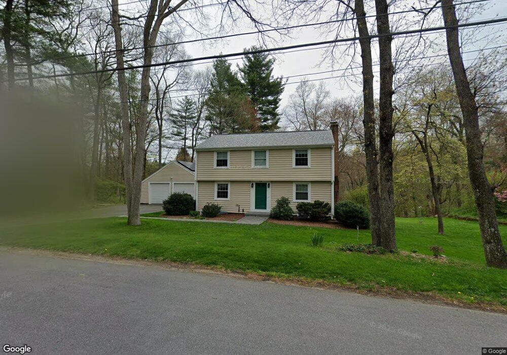
This home is located at 33 Oneida Rd, Acton, MA 01720 and is currently estimated at $809,587, approximately $485 per square foot. 33 Oneida Rd is a home located in Middlesex County with nearby schools including Acton-Boxborough Regional High School.
Ownership History
Date
Name
Owned For
Owner Type
Purchase Details
Closed on
Sep 9, 2016
Sold by
Harris Frank I and Harris Virginia M
Bought by
Harris Childrens Gift
Current Estimated Value
Purchase Details
Closed on
Jul 24, 1981
Bought by
Harris F Ian
Create a Home Valuation Report for This Property
The Home Valuation Report is an in-depth analysis detailing your home's value as well as a comparison with similar homes in the area
Home Values in the Area
Average Home Value in this Area
Purchase History
| Date | Buyer | Sale Price | Title Company |
|---|---|---|---|
| Harris Childrens Gift | -- | -- | |
| Harris F Ian | -- | -- |
Source: Public Records
Mortgage History
| Date | Status | Borrower | Loan Amount |
|---|---|---|---|
| Previous Owner | Harris F Ian | $40,000 | |
| Previous Owner | Harris F Ian | $75,000 | |
| Previous Owner | Harris F Ian | $25,000 |
Source: Public Records
Tax History
| Year | Tax Paid | Tax Assessment Tax Assessment Total Assessment is a certain percentage of the fair market value that is determined by local assessors to be the total taxable value of land and additions on the property. | Land | Improvement |
|---|---|---|---|---|
| 2025 | $11,400 | $664,700 | $317,200 | $347,500 |
| 2024 | $10,710 | $642,500 | $317,200 | $325,300 |
| 2023 | $10,578 | $602,400 | $288,200 | $314,200 |
| 2022 | $10,028 | $515,600 | $250,700 | $264,900 |
| 2021 | $9,769 | $482,900 | $232,100 | $250,800 |
| 2020 | $9,222 | $479,300 | $232,100 | $247,200 |
| 2019 | $8,722 | $450,300 | $232,100 | $218,200 |
| 2018 | $8,593 | $443,400 | $232,100 | $211,300 |
| 2017 | $8,505 | $446,200 | $232,100 | $214,100 |
| 2016 | $8,338 | $433,600 | $232,100 | $201,500 |
| 2015 | $8,251 | $433,100 | $232,100 | $201,000 |
| 2014 | $8,041 | $413,400 | $232,100 | $181,300 |
Source: Public Records
Map
Nearby Homes
- 60 Nashoba Rd
- 5 Perkins Ln
- 4 Littlefield Rd
- 79 Charter Rd
- 20 Joseph Reed Ln
- 235 Arlington St
- 4 Omega Way
- 18 Hayward Rd
- 11 Braebrook
- 246 Main St Unit 2
- 33 Meadowbrook Rd
- 7 Kelley Rd
- 92 Willow St Unit 3
- 92 Willow St Unit 2
- 90 Willow St Unit 1
- 46 Taylor Rd
- 491 Main St
- 524 Main St
- 305 Harwood Ave
- 184 Main St Unit 3
Your Personal Tour Guide
Ask me questions while you tour the home.