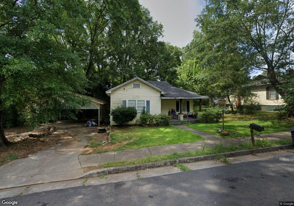
33 Perry St Manchester, GA 31816
Estimated Value: $55,000 - $113,000
3
Beds
1
Bath
912
Sq Ft
$93/Sq Ft
Est. Value
About This Home
This home is located at 33 Perry St, Manchester, GA 31816 and is currently estimated at $84,671, approximately $92 per square foot. 33 Perry St is a home located in Meriwether County with nearby schools including Mountain View Elementary School, Manchester Middle School, and Manchester High School.
Ownership History
Date
Name
Owned For
Owner Type
Purchase Details
Closed on
May 15, 2020
Sold by
Orr Robert L
Bought by
Martin Ronell
Current Estimated Value
Purchase Details
Closed on
May 2, 2007
Sold by
Taylor Dawson Lee
Bought by
Orr Robert L
Purchase Details
Closed on
Jan 12, 2007
Sold by
Moncrief Jeffery E
Bought by
Taylor Dawson Lee
Purchase Details
Closed on
Jan 11, 2007
Sold by
Collins Buren Coel
Bought by
Moncrief Jeffery E
Purchase Details
Closed on
May 9, 2005
Sold by
Elliott Sheilia B
Bought by
Moncrief Jeffery E
Purchase Details
Closed on
Jan 1, 1994
Bought by
Elliott Sheila B
Purchase Details
Closed on
Mar 1, 1993
Sold by
Jessie Kate Bates
Purchase Details
Closed on
Jan 1, 1967
Bought by
Jessie Kate Bates
Create a Home Valuation Report for This Property
The Home Valuation Report is an in-depth analysis detailing your home's value as well as a comparison with similar homes in the area
Home Values in the Area
Average Home Value in this Area
Purchase History
| Date | Buyer | Sale Price | Title Company |
|---|---|---|---|
| Martin Ronell | $12,700 | -- | |
| Orr Robert L | $32,500 | -- | |
| Taylor Dawson Lee | $30,000 | -- | |
| Moncrief Jeffery E | -- | -- | |
| Moncrief Jeffery E | -- | -- | |
| Elliott Sheila B | -- | -- | |
| -- | -- | -- | |
| Jessie Kate Bates | $3,000 | -- |
Source: Public Records
Tax History Compared to Growth
Tax History
| Year | Tax Paid | Tax Assessment Tax Assessment Total Assessment is a certain percentage of the fair market value that is determined by local assessors to be the total taxable value of land and additions on the property. | Land | Improvement |
|---|---|---|---|---|
| 2024 | $479 | $10,160 | $2,240 | $7,920 |
| 2023 | $492 | $10,160 | $2,240 | $7,920 |
| 2022 | $492 | $10,160 | $2,240 | $7,920 |
| 2021 | $324 | $10,160 | $2,240 | $7,920 |
| 2020 | $326 | $10,160 | $2,240 | $7,920 |
| 2019 | $328 | $10,160 | $2,240 | $7,920 |
| 2018 | $331 | $10,160 | $2,240 | $7,920 |
| 2017 | $335 | $10,160 | $2,240 | $7,920 |
| 2016 | $335 | $10,160 | $2,240 | $7,920 |
| 2015 | $301 | $9,120 | $1,200 | $7,920 |
| 2014 | $301 | $9,120 | $1,200 | $7,920 |
| 2013 | -- | $9,120 | $1,200 | $7,920 |
Source: Public Records
Map
Nearby Homes
- 19 Truitt St
- 12 Truitt St
- 5 Jay St
- LOTS 6,7 & 8 E Main St
- 36 E 2nd St
- 380 Elm St
- 312 2nd Ave
- 701 Jd Parham Dr
- 3.26 ACRES Mountain Ridge Dr
- 802 Jd Parham Dr
- 522 4th St
- 305 Holy Hill Place
- 434 Phil Howe Rd
- 200 Hunt Cir
- 1600 Grant Ave
- 1772 Grant Ave
- 514 Farris Blvd
- 617 Mayes Way
- 286 Starling Rd
- 621 Mayes Way