Estimated Value: $569,426 - $785,000
Studio
--
Bath
1,656
Sq Ft
$405/Sq Ft
Est. Value
About This Home
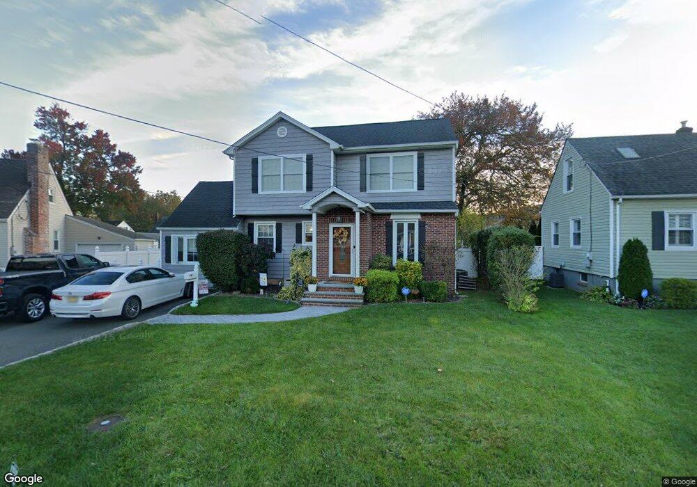
This home is located at 33 Prescott Turn, Clark, NJ 07066 and is currently estimated at $670,857, approximately $405 per square foot. 33 Prescott Turn is a home located in Union County with nearby schools including Valley Road Elementary School, Carl H. Kumpf Middle School, and Arthur L. Johnson High School.
Ownership History
Date
Name
Owned For
Owner Type
Purchase Details
Closed on
Apr 12, 2003
Sold by
Seamon Henry
Bought by
Woods Matthew and Woods Michelle
Current Estimated Value
Home Financials for this Owner
Home Financials are based on the most recent Mortgage that was taken out on this home.
Original Mortgage
$225,265
Outstanding Balance
$95,990
Interest Rate
5.64%
Estimated Equity
$574,867
Create a Home Valuation Report for This Property
The Home Valuation Report is an in-depth analysis detailing your home's value as well as a comparison with similar homes in the area
Home Values in the Area
Average Home Value in this Area
Purchase History
| Date | Buyer | Sale Price | Title Company |
|---|---|---|---|
| Woods Matthew | $249,000 | -- |
Source: Public Records
Mortgage History
| Date | Status | Borrower | Loan Amount |
|---|---|---|---|
| Open | Woods Matthew | $225,265 |
Source: Public Records
Tax History
| Year | Tax Paid | Tax Assessment Tax Assessment Total Assessment is a certain percentage of the fair market value that is determined by local assessors to be the total taxable value of land and additions on the property. | Land | Improvement |
|---|---|---|---|---|
| 2025 | $9,533 | $430,600 | $223,700 | $206,900 |
| 2024 | $9,391 | $430,600 | $223,700 | $206,900 |
| 2023 | $9,391 | $430,600 | $223,700 | $206,900 |
| 2022 | $9,120 | $430,600 | $223,700 | $206,900 |
| 2021 | $9,672 | $108,800 | $39,000 | $69,800 |
| 2020 | $9,515 | $108,800 | $39,000 | $69,800 |
| 2019 | $9,419 | $108,800 | $39,000 | $69,800 |
| 2018 | $9,306 | $108,800 | $39,000 | $69,800 |
| 2017 | $9,157 | $108,800 | $39,000 | $69,800 |
| 2016 | $5,950 | $73,400 | $39,000 | $34,400 |
| 2015 | $5,890 | $73,400 | $39,000 | $34,400 |
| 2014 | $5,766 | $73,400 | $39,000 | $34,400 |
Source: Public Records
Map
Nearby Homes
- 157 Westfield Ave
- 22 Washington St
- 1044 Madison Hill Rd
- 52 Broadway
- 44 Joseph St
- 30 Brant Ave
- 272 Westfield Ave
- 85 Fulton St
- 1206 Westfield Ave
- 45 Lexington Blvd
- 66 Lincoln Blvd
- 814 Falesky St
- 793 Garden St
- 17 Rolling Hill Way
- 1472 Jefferson Ave
- 262 Valley Rd
- 275 Valley Rd
- 1355 Jefferson Ave
- 1166 Jefferson Ave
- 205 West Ln
- 35 Prescott Turn
- 31 Prescott Turn
- 120 Gertrude St
- 124 Gertrude St
- 37 Prescott Turn
- 112 Gertrude St
- 27 Prescott Turn
- 26 Prescott Turn
- 28 Prescott Turn
- 132 Gertrude St
- 30 Prescott Turn
- 110 Gertrude St
- 25 Prescott Turn
- 24 Prescott Turn
- 39B Prescott Turn
- 39A Prescott Turn
- 138 Gertrude St
- 50 Prescott Turn
- 117 Gertrude St
- 113 Gertrude St
Your Personal Tour Guide
Ask me questions while you tour the home.