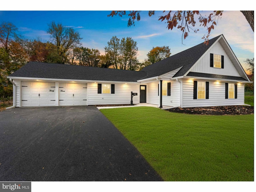
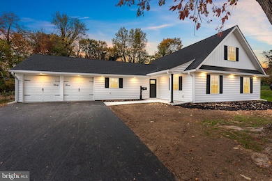


33 Red Rose Way Levittown, PA 19056
Red Rose Gate NeighborhoodEstimated payment $4,271/month
Highlights
- 0.75 Acre Lot
- 1 Fireplace
- 1 Car Attached Garage
- Contemporary Architecture
- No HOA
- Living Room
About This Home
Welcome to this practically new fully renovated 5 bedroom, 3 full bath home featuring extensive updates throughout. This property has been completely modernized with all new electric and plumbing systems both in the house and under the house, new windows, insulation, drywall, trim, and a 3-zone HVAC system for efficient heating and cooling. The exterior includes a covered front porch, new upgraded insulated siding, new roof, and a 1.5-car garage with a new spacious 4+ car driveway.
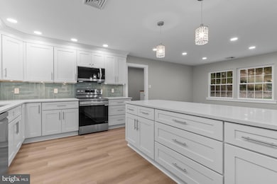
The open-concept first floor offers recessed lighting, ceiling fans, and luxury plank flooring in all main areas. The kitchen features new stainless steel appliances, granite countertops, tile backsplash, pendant lighting, and cabinets with crown molding. A pass-through breakfast bar connects to the dining area, which flows into the living and family rooms, providing multiple gathering spaces.
The first-floor primary bedroom includes carpet flooring, double closets, a ceiling fan, and a private full bath with tiled shower and updated fixtures. Two additional bedrooms and a second full bath with tile surround are also located on this floor, along with a separate laundry area for convenience.
The second floor includes two additional large bedrooms with recessed lighting and carpet, and a third full bath with a tiled tub/shower surround and modern finishes.
Additional highlights include new interior doors, trim, hardware, recessed lighting throughout, and new electric as well as plumbing beneath the home. The 3-zone HVAC allows for separate temperature control on each level.
With approximately 3,000+ square feet of finished living space, this home offers flexibility for multi-generational living, home office setups, or guest accommodations. Conveniently located near major highways, local schools, restaurants, and shopping centers. A move-in ready property with every major system replaced and updated. Please note that some photos have been virtually staged/digitally enhanced which can alter some aspects of the home. These particular photos are for illustration purposes only. There is an un-staged photo for every virtually staged photo.
Listing Agent
(215) 783-8961 rich@richwebbgroup.com Keller Williams Real Estate - Newtown License #RS306752 Listed on: 11/06/2025

Home Details
Home Type
- Single Family
Est. Annual Taxes
- $6,892
Year Built
- Built in 1956 | Remodeled in 2025
Lot Details
- 0.75 Acre Lot
- Property is zoned R1
Parking
- 1 Car Attached Garage
- 4 Driveway Spaces
- Parking Storage or Cabinetry
- Front Facing Garage
- Garage Door Opener
Home Design
- Contemporary Architecture
- Slab Foundation
- Frame Construction
Interior Spaces
- 3,124 Sq Ft Home
- Property has 2 Levels
- Recessed Lighting
- Pendant Lighting
- 1 Fireplace
- Family Room
- Living Room
- Dining Room
Bedrooms and Bathrooms
Utilities
- Central Air
- Heat Pump System
- Electric Water Heater
Community Details
- No Home Owners Association
- Red Rose Gate Subdivision
Listing and Financial Details
- Tax Lot 227
- Assessor Parcel Number 22-054-227
Map
Home Values in the Area
Average Home Value in this Area
Tax History
| Year | Tax Paid | Tax Assessment Tax Assessment Total Assessment is a certain percentage of the fair market value that is determined by local assessors to be the total taxable value of land and additions on the property. | Land | Improvement |
|---|---|---|---|---|
| 2025 | $6,340 | $29,120 | $6,960 | $22,160 |
| 2024 | $6,340 | $29,120 | $6,960 | $22,160 |
| 2023 | $6,239 | $29,120 | $6,960 | $22,160 |
| 2022 | $6,075 | $29,120 | $6,960 | $22,160 |
| 2021 | $6,075 | $29,120 | $6,960 | $22,160 |
| 2020 | $6,002 | $29,120 | $6,960 | $22,160 |
| 2019 | $5,868 | $29,120 | $6,960 | $22,160 |
| 2018 | $5,761 | $29,120 | $6,960 | $22,160 |
| 2017 | $5,613 | $29,120 | $6,960 | $22,160 |
| 2016 | $5,613 | $29,120 | $6,960 | $22,160 |
| 2015 | $5,803 | $29,120 | $6,960 | $22,160 |
| 2014 | $5,803 | $29,120 | $6,960 | $22,160 |
Property History
| Date | Event | Price | List to Sale | Price per Sq Ft |
|---|---|---|---|---|
| 11/06/2025 11/06/25 | For Sale | $699,999 | -- | $224 / Sq Ft |
Purchase History
| Date | Type | Sale Price | Title Company |
|---|---|---|---|
| Special Warranty Deed | $375,000 | World Wide Land Transfer | |
| Interfamily Deed Transfer | -- | None Available | |
| Quit Claim Deed | -- | -- |
Source: Bright MLS
MLS Number: PABU2108644
APN: 22-054-227
Disclaimer: Certain information contained herein is derived from information provided by parties other than Homes.com. All information provided is deemed reliable, but is not guaranteed to be accurate and should be independently verified.
![]() The data relating to real estate for sale on this website appears in part through the BRIGHT Internet Data Exchange program, a voluntary cooperative exchange of property listing data between licensed real estate brokerage firms, and is provided by BRIGHT through a licensing agreement.
The data relating to real estate for sale on this website appears in part through the BRIGHT Internet Data Exchange program, a voluntary cooperative exchange of property listing data between licensed real estate brokerage firms, and is provided by BRIGHT through a licensing agreement.
Listing information is from various brokers who participate in the Bright MLS IDX program and not all listings may be visible on the site.
The property information being provided on or through the website is for the personal, non-commercial use of consumers and such information may not be used for any purpose other than to identify prospective properties consumers may be interested in purchasing.
Some properties which appear for sale on the website may no longer be available because they are for instance, under contract, sold or are no longer being offered for sale.
Property information displayed is deemed reliable but is not guaranteed.
Copyright 2025 Bright MLS, Inc.
- 14 Cleft Rock Rd
- 23 Crystal Place
- 19 Cobalt Ridge Dr N
- 7 Canal Rd
- 75 Flamehill Rd
- 88 Forsythia Dr N
- 114 Nursery Ave
- 154 Juniper Dr
- 94 Juniper Dr
- 14 Cinnamon Rd
- 17 Quay Rd
- 283 Snowball Dr
- 301 Snowball Dr
- 212 Apple St
- 26 Queen Lily Rd
- 58 Queen Lily Rd
- 8 Haven Rd
- 479 Stanford Rd
- 0 Durham Rd
- 11 Dolphin Rd
- 35 Red Berry Rd
- 24 Rose Apple Rd
- 77 Fieldstone Rd
- 51 Seckelpear Rd
- 15 Queen Anne Rd
- 1338 Veterans Hwy
- 1228 New Rodgers Rd
- 99 Indian Creek Pass
- 936 Durham Rd
- 1970 Veterans Hwy
- 12 Indigo Rd
- 800 Trenton Rd
- 209 Yorkshire Rd
- 289 Goldenridge Dr
- 10 Blue Ridge Dr
- 71 Handy Rd
- 2132 Durham Rd
- 2180 Veterans Hwy
- 240 Goldenridge Dr
- 84 Whitewood Dr