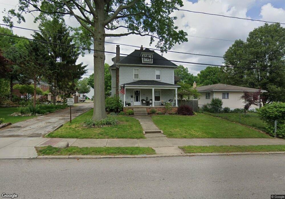
33 W Hiram St Barberton, OH 44203
North Barberton NeighborhoodEstimated Value: $175,000 - $202,000
5
Beds
4
Baths
2,000
Sq Ft
$93/Sq Ft
Est. Value
About This Home
This home is located at 33 W Hiram St, Barberton, OH 44203 and is currently estimated at $186,518, approximately $93 per square foot. 33 W Hiram St is a home located in Summit County with nearby schools including Barberton Middle School, Barberton Intermediate School 3-5, and Barberton High School.
Ownership History
Date
Name
Owned For
Owner Type
Purchase Details
Closed on
Dec 17, 2009
Sold by
Fleet Mary Kay
Bought by
Szittai Shannon L
Current Estimated Value
Home Financials for this Owner
Home Financials are based on the most recent Mortgage that was taken out on this home.
Original Mortgage
$106,043
Outstanding Balance
$69,167
Interest Rate
4.9%
Mortgage Type
FHA
Estimated Equity
$117,351
Create a Home Valuation Report for This Property
The Home Valuation Report is an in-depth analysis detailing your home's value as well as a comparison with similar homes in the area
Home Values in the Area
Average Home Value in this Area
Purchase History
| Date | Buyer | Sale Price | Title Company |
|---|---|---|---|
| Szittai Shannon L | $108,000 | Chicago Title Insurance Co |
Source: Public Records
Mortgage History
| Date | Status | Borrower | Loan Amount |
|---|---|---|---|
| Open | Szittai Shannon L | $106,043 |
Source: Public Records
Tax History Compared to Growth
Tax History
| Year | Tax Paid | Tax Assessment Tax Assessment Total Assessment is a certain percentage of the fair market value that is determined by local assessors to be the total taxable value of land and additions on the property. | Land | Improvement |
|---|---|---|---|---|
| 2025 | $2,537 | $45,728 | $9,415 | $36,313 |
| 2024 | $2,537 | $45,728 | $9,415 | $36,313 |
| 2023 | $2,537 | $45,728 | $9,415 | $36,313 |
| 2022 | $2,045 | $30,615 | $6,153 | $24,462 |
| 2021 | $1,762 | $30,615 | $6,153 | $24,462 |
| 2020 | $1,724 | $30,610 | $6,150 | $24,460 |
| 2019 | $1,531 | $24,620 | $5,420 | $19,200 |
| 2018 | $1,507 | $24,620 | $5,420 | $19,200 |
| 2017 | $1,527 | $24,620 | $5,420 | $19,200 |
| 2016 | $1,530 | $24,620 | $5,420 | $19,200 |
| 2015 | $1,527 | $24,620 | $5,420 | $19,200 |
| 2014 | $1,519 | $24,620 | $5,420 | $19,200 |
| 2013 | $1,466 | $24,640 | $5,420 | $19,220 |
Source: Public Records
Map
Nearby Homes
- 818 N Summit St
- 30 W Hiram St
- 277 Glenn St
- 103 Mitchell St
- 146 Hermann St
- 137 Hermann St
- 143 Glenn St
- 690 Saint Clair Ave
- 0 Romig Ave
- 44 W Summit St
- 213 Hermann St
- 1924 Caroline Ave
- 76 Hazelwood Ave
- 117 Fernwood Ave
- 250 Evergreen St
- 103 & 103 1/2 Fernwood Ave
- 1960 Newton St
- 645 Madison Ave
- 1150 Wooster Rd N
- 0 Wooster Rd N
- 780 Graceland Ave
- 43 W Hiram St
- 788 Graceland Ave
- 787 N Summit St
- 787 N Summit St Unit 2
- 792 Graceland Ave
- 21 W Hiram St
- 36 W Hiram St
- 26 W Hiram St
- 791 N Summit St
- 787 Graceland Ave
- 796 Graceland Ave
- 793 Graceland Ave
- 9 W Hiram St
- 776 N Summit St
- 782 N Summit St
- 126 W State St
- 797 Graceland Ave
- 801 N Summit St
- 753 N Summit St