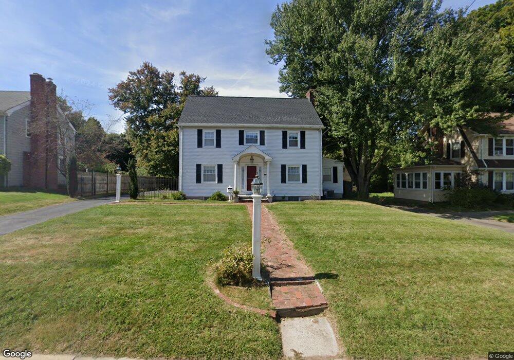
33 West St Middletown, CT 06457
Westfield NeighborhoodEstimated Value: $402,000 - $496,000
3
Beds
2
Baths
1,851
Sq Ft
$235/Sq Ft
Est. Value
About This Home
This home is located at 33 West St, Middletown, CT 06457 and is currently estimated at $434,787, approximately $234 per square foot. 33 West St is a home located in Middlesex County with nearby schools including Wilbert Snow Elementary School, Middletown High School, and St John Paul II School.
Ownership History
Date
Name
Owned For
Owner Type
Purchase Details
Closed on
Jul 27, 2001
Sold by
Gasior Michael and Gasior Vanessa J
Bought by
Trinkaus Ann L
Current Estimated Value
Home Financials for this Owner
Home Financials are based on the most recent Mortgage that was taken out on this home.
Original Mortgage
$175,920
Interest Rate
7.18%
Purchase Details
Closed on
Sep 30, 1987
Sold by
Mccain Jack A
Bought by
Gasior Michael
Home Financials for this Owner
Home Financials are based on the most recent Mortgage that was taken out on this home.
Original Mortgage
$147,900
Interest Rate
10.31%
Create a Home Valuation Report for This Property
The Home Valuation Report is an in-depth analysis detailing your home's value as well as a comparison with similar homes in the area
Home Values in the Area
Average Home Value in this Area
Purchase History
| Date | Buyer | Sale Price | Title Company |
|---|---|---|---|
| Trinkaus Ann L | $219,900 | -- | |
| Gasior Michael | $184,900 | -- |
Source: Public Records
Mortgage History
| Date | Status | Borrower | Loan Amount |
|---|---|---|---|
| Open | Gasior Michael | $152,828 | |
| Closed | Gasior Michael | $175,920 | |
| Previous Owner | Gasior Michael | $152,800 | |
| Previous Owner | Gasior Michael | $147,900 |
Source: Public Records
Tax History
| Year | Tax Paid | Tax Assessment Tax Assessment Total Assessment is a certain percentage of the fair market value that is determined by local assessors to be the total taxable value of land and additions on the property. | Land | Improvement |
|---|---|---|---|---|
| 2025 | $8,986 | $231,000 | $63,020 | $167,980 |
| 2024 | $8,501 | $231,000 | $63,020 | $167,980 |
| 2023 | $8,108 | $231,000 | $63,020 | $167,980 |
| 2022 | $7,438 | $169,050 | $39,680 | $129,370 |
| 2021 | $7,438 | $169,050 | $39,680 | $129,370 |
| 2020 | $7,366 | $166,660 | $39,680 | $126,980 |
| 2019 | $7,400 | $166,660 | $39,680 | $126,980 |
| 2018 | $7,283 | $166,660 | $39,680 | $126,980 |
| 2017 | $6,649 | $156,810 | $45,830 | $110,980 |
| 2016 | $6,461 | $156,810 | $45,830 | $110,980 |
| 2015 | $6,210 | $156,810 | $45,830 | $110,980 |
| 2014 | $6,272 | $156,810 | $45,830 | $110,980 |
Source: Public Records
Map
Nearby Homes
- 104 Boston Rd
- 160 Boston Rd
- 27 Barbara Rd
- 17 Mckenna Dr
- 1 Nathan Hale Rd
- 2 Nathan Hale Rd
- 4 Nathan Hale Rd
- 3 Nathan Hale Rd
- 5 Nathan Hale Rd
- 204 Hickory Cir
- 183 Aston Ln
- 82 Westfield Terrace
- 3 Huber Manor
- 175 Lincoln St
- 23 Hotchkiss St
- 201 College St Unit 26
- 146 Liberty St
- 132 Grand St
- 70 Jack English Dr
- 177 Pearl St