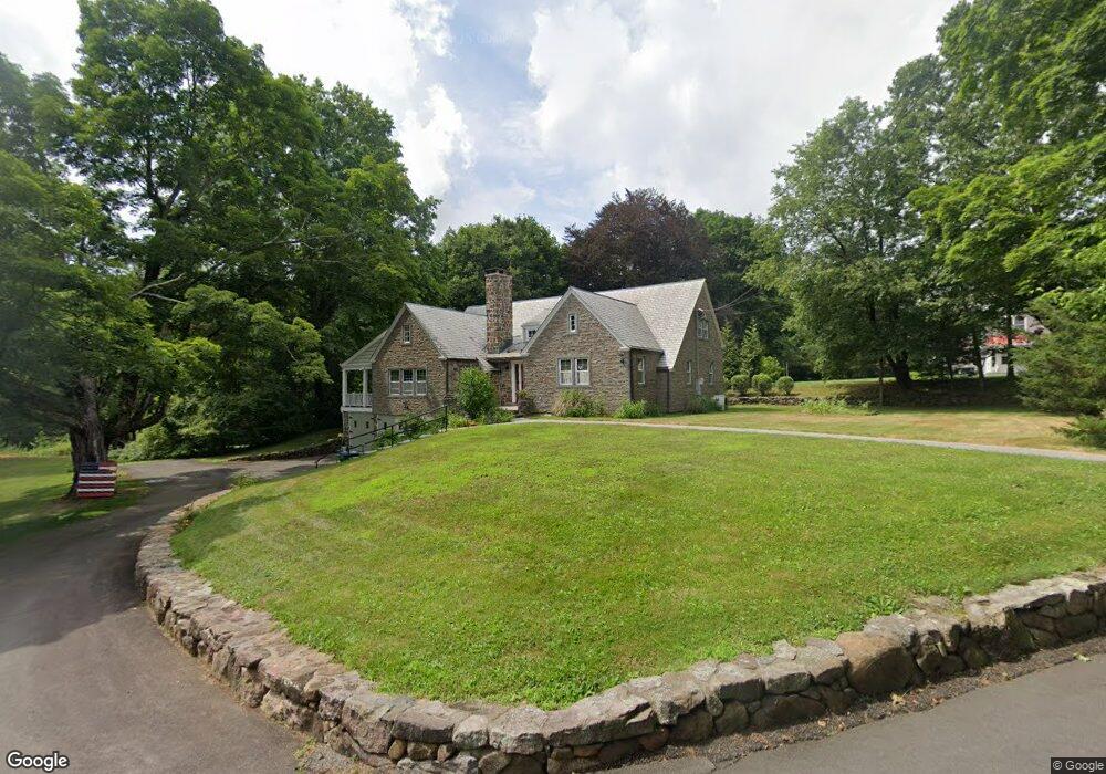
33 Westerly Dr Hamden, CT 06518
Estimated Value: $525,000 - $688,000
4
Beds
3
Baths
2,252
Sq Ft
$257/Sq Ft
Est. Value
About This Home
This home is located at 33 Westerly Dr, Hamden, CT 06518 and is currently estimated at $579,541, approximately $257 per square foot. 33 Westerly Dr is a home located in New Haven County with nearby schools including West Woods School, Hamden Middle School, and Hamden High School.
Ownership History
Date
Name
Owned For
Owner Type
Purchase Details
Closed on
Apr 23, 2007
Sold by
White Douglas
Bought by
Coassin Michael S
Current Estimated Value
Home Financials for this Owner
Home Financials are based on the most recent Mortgage that was taken out on this home.
Original Mortgage
$170,000
Interest Rate
6.19%
Purchase Details
Closed on
Jun 19, 2003
Sold by
Lang Stephen W
Bought by
White Doris L
Purchase Details
Closed on
Mar 31, 1987
Sold by
Est Freda G Davis
Bought by
Barker Robert W
Create a Home Valuation Report for This Property
The Home Valuation Report is an in-depth analysis detailing your home's value as well as a comparison with similar homes in the area
Home Values in the Area
Average Home Value in this Area
Purchase History
| Date | Buyer | Sale Price | Title Company |
|---|---|---|---|
| Coassin Michael S | $520,000 | -- | |
| White Doris L | $575,000 | -- | |
| Barker Robert W | $320,000 | -- |
Source: Public Records
Mortgage History
| Date | Status | Borrower | Loan Amount |
|---|---|---|---|
| Open | Barker Robert W | $125,000 | |
| Closed | Barker Robert W | $170,000 | |
| Previous Owner | Barker Robert W | $319,555 |
Source: Public Records
Tax History
| Year | Tax Paid | Tax Assessment Tax Assessment Total Assessment is a certain percentage of the fair market value that is determined by local assessors to be the total taxable value of land and additions on the property. | Land | Improvement |
|---|---|---|---|---|
| 2025 | $16,655 | $321,020 | $53,690 | $267,330 |
| 2024 | $12,110 | $217,770 | $34,860 | $182,910 |
| 2023 | $12,278 | $217,770 | $34,860 | $182,910 |
| 2022 | $12,082 | $217,770 | $34,860 | $182,910 |
| 2021 | $11,420 | $217,770 | $34,860 | $182,910 |
| 2020 | $10,847 | $208,670 | $83,440 | $125,230 |
| 2019 | $10,196 | $208,670 | $83,440 | $125,230 |
| 2018 | $10,008 | $208,670 | $83,440 | $125,230 |
| 2017 | $9,444 | $208,670 | $83,440 | $125,230 |
| 2016 | $9,465 | $208,670 | $83,440 | $125,230 |
| 2015 | $9,304 | $227,640 | $100,800 | $126,840 |
| 2014 | $9,090 | $227,640 | $100,800 | $126,840 |
Source: Public Records
Map
Nearby Homes
- 2974 Whitney Ave
- 2838 Whitney Ave Unit 2
- 110 Dickerman St
- 51 Charlton Hill Rd
- 90 Rolling Ridge Rd
- 93 Cannon St
- 18 Anns Farm Rd
- 55 Forest St
- 80 Flower Dr
- 161 Sleeping Giant Dr
- 4183 Whitney Ave
- 6 Liberty Terrace
- 1 Pond Hollow Unit 1
- 1400 Hartford Turnpike Unit 24
- 142 Washington Ave
- 18 Day Spring Ave
- 46 Forest Ct N
- 9 Russell Rd
- 3409 Whitney Ave Unit 1
- 51 Greenes Ridge Rd
Your Personal Tour Guide
Ask me questions while you tour the home.