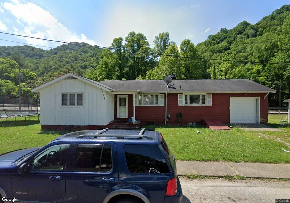
330 Barrett Cir Wharton, WV 25208
Estimated Value: $37,000 - $74,609
3
Beds
2
Baths
1,424
Sq Ft
$42/Sq Ft
Est. Value
About This Home
This home is located at 330 Barrett Cir, Wharton, WV 25208 and is currently estimated at $59,152, approximately $41 per square foot. 330 Barrett Cir is a home.
Ownership History
Date
Name
Owned For
Owner Type
Purchase Details
Closed on
Mar 14, 2018
Sold by
Castlerock 2017 Llc
Bought by
White Scotty D and White Carla D
Current Estimated Value
Purchase Details
Closed on
Mar 15, 2017
Sold by
Secretary Of Housing And Urban Developme
Bought by
Castlerock 2017 Llc
Purchase Details
Closed on
Jun 30, 2008
Sold by
Ritchie Paul A and Ritchie Viola M
Bought by
Tackett Steven Lee
Home Financials for this Owner
Home Financials are based on the most recent Mortgage that was taken out on this home.
Original Mortgage
$764,825
Interest Rate
6.13%
Create a Home Valuation Report for This Property
The Home Valuation Report is an in-depth analysis detailing your home's value as well as a comparison with similar homes in the area
Purchase History
| Date | Buyer | Sale Price | Title Company |
|---|---|---|---|
| White Scotty D | $20,000 | None Available | |
| Castlerock 2017 Llc | -- | None Available | |
| Tackett Steven Lee | $76,000 | -- |
Source: Public Records
Mortgage History
| Date | Status | Borrower | Loan Amount |
|---|---|---|---|
| Previous Owner | Tackett Steven Lee | $764,825 |
Source: Public Records
Tax History
| Year | Tax Paid | Tax Assessment Tax Assessment Total Assessment is a certain percentage of the fair market value that is determined by local assessors to be the total taxable value of land and additions on the property. | Land | Improvement |
|---|---|---|---|---|
| 2025 | $705 | $28,140 | $6,000 | $22,140 |
| 2024 | $705 | $28,140 | $6,000 | $22,140 |
| 2023 | $666 | $26,520 | $6,000 | $20,520 |
| 2022 | $629 | $24,840 | $6,000 | $18,840 |
| 2021 | $604 | $23,880 | $6,000 | $17,880 |
| 2020 | $605 | $23,880 | $6,000 | $17,880 |
| 2019 | $605 | $23,880 | $6,000 | $17,880 |
| 2018 | $654 | $25,800 | $6,000 | $19,800 |
| 2017 | $0 | $24,240 | $6,000 | $18,240 |
| 2016 | $415 | $32,760 | $6,000 | $26,760 |
| 2015 | $386 | $30,480 | $6,000 | $24,480 |
| 2014 | $563 | $44,400 | $6,000 | $38,400 |
Source: Public Records
Map
Nearby Homes
- 314 Mckinley St
- 41 Flat Top Camp Rd
- 23336 Pond Fork Rd
- 10914 Buffalo Creek Rd
- 0 Pond Fork Rd
- 0 Packville Marfork Rd
- 113 Caldwell Ln
- 112 Tranquil Ct
- 198 Hunter Addition Rd
- 22143 Spruce River Rd
- 20276 Spruce River Rd
- 1126 Drews Creek
- 33150 Coal River Rd
- 21075 Spruce River Rd
- 80 Sleepy Hollow Rd
- 94 Lewis Rd
- 135 Amber Ct
- 186 Twenty-One Row Hollow
- 25 Price Petry Dr
- 6026 Pond Fork Rd
- 290 Barrett Cir
- 356 Barrett Cir
- 256 Barrett Cir
- 363 Barrett Cir
- 398 Barrett Cir
- 255 Barrett Cir
- 443 Barrett Cir
- 432 Barrett Cir
- 226 Barrett Cir
- 75 Denver Dr
- 466 Barrett Cir
- 189 Barrett Cir
- 99 Denver Dr
- 495 Barrett Cir
- 194 Barrett Cir
- 502 Barrett Cir
- 609 Barrett Cir
- 623 Barrett Cir
- 583 Barrett Cir
- 168 Barrett Cir
Your Personal Tour Guide
Ask me questions while you tour the home.