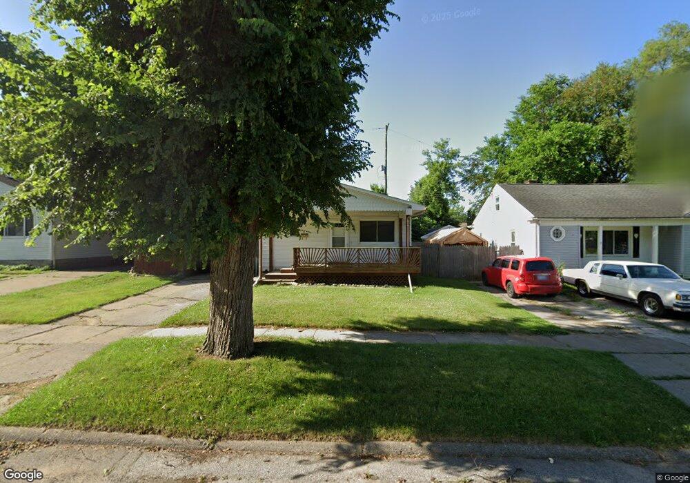
330 Burroughs Ave Flint, MI 48507
Circle Drive NeighborhoodEstimated Value: $72,000 - $88,000
3
Beds
1
Bath
912
Sq Ft
$87/Sq Ft
Est. Value
About This Home
This home is located at 330 Burroughs Ave, Flint, MI 48507 and is currently estimated at $78,913, approximately $86 per square foot. 330 Burroughs Ave is a home located in Genesee County with nearby schools including Freeman Elementary School, Flint Southwestern Classical Academy, and International Academy of Flint (K-12).
Ownership History
Date
Name
Owned For
Owner Type
Purchase Details
Closed on
Apr 14, 2009
Sold by
Secretary Of Housing & Urban Development
Bought by
Allen Carolyn
Current Estimated Value
Purchase Details
Closed on
Nov 17, 2008
Sold by
Wells Fargo Bank Na
Bought by
The Secretary Of Housing & Urban Develop
Purchase Details
Closed on
May 14, 2008
Sold by
Lang Mack J and Lang Glenda F
Bought by
Wells Fargo Bank Na
Purchase Details
Closed on
Aug 14, 2003
Sold by
Mihailoff Nicholas A and Mihailoff Yvonne
Bought by
Lang Mack and Lang Glenda F
Home Financials for this Owner
Home Financials are based on the most recent Mortgage that was taken out on this home.
Original Mortgage
$84,295
Interest Rate
6.43%
Mortgage Type
FHA
Create a Home Valuation Report for This Property
The Home Valuation Report is an in-depth analysis detailing your home's value as well as a comparison with similar homes in the area
Home Values in the Area
Average Home Value in this Area
Purchase History
| Date | Buyer | Sale Price | Title Company |
|---|---|---|---|
| Allen Carolyn | $25,000 | None Available | |
| The Secretary Of Housing & Urban Develop | -- | None Available | |
| Wells Fargo Bank Na | $83,735 | None Available | |
| Lang Mack | $85,000 | Lawyers Title Ins Corp |
Source: Public Records
Mortgage History
| Date | Status | Borrower | Loan Amount |
|---|---|---|---|
| Previous Owner | Lang Mack | $84,295 |
Source: Public Records
Tax History
| Year | Tax Paid | Tax Assessment Tax Assessment Total Assessment is a certain percentage of the fair market value that is determined by local assessors to be the total taxable value of land and additions on the property. | Land | Improvement |
|---|---|---|---|---|
| 2025 | $1,026 | $36,000 | $0 | $0 |
| 2024 | $928 | $32,200 | $0 | $0 |
| 2023 | $910 | $29,700 | $0 | $0 |
| 2022 | $0 | $24,300 | $0 | $0 |
| 2021 | $947 | $22,300 | $0 | $0 |
| 2020 | $853 | $17,800 | $0 | $0 |
| 2019 | $830 | $14,000 | $0 | $0 |
| 2018 | $833 | $12,200 | $0 | $0 |
| 2017 | $809 | $0 | $0 | $0 |
| 2016 | $804 | $0 | $0 | $0 |
| 2015 | -- | $0 | $0 | $0 |
| 2014 | -- | $0 | $0 | $0 |
| 2012 | -- | $15,600 | $0 | $0 |
Source: Public Records
Map
Nearby Homes
- 326 Burroughs Ave
- 352 Buckingham Ave
- 416 Burroughs Ave
- 361 Buckingham Ave
- 4127 Custer Ave
- 4133 Custer Ave
- 4126 Circle Dr
- 338 Browning Ave
- 4526 Milton Dr
- 621 Burroughs Ave
- 630 Buckingham Ave
- 530 McKeighan Ave
- 617 McKeighan Ave
- 213 E Lakeview Ave
- 115 E Livingston Dr
- 3218 Collingwood Pkwy
- 802 McKeighan Ave
- 818 Dell Ave
- 3902 Cuthbertson St
- 3505 Comanche Ave
- 334 Burroughs Ave
- 338 Burroughs Ave
- 320 Burroughs Ave
- 309 Leta Ave
- 313 Leta Ave
- 301 Leta Ave
- 4031 Red Arrow Rd
- 317 Leta Ave
- 342 Burroughs Ave
- 4021 Red Arrow Rd
- 333 Burroughs Ave
- 329 Burroughs Ave
- 341 Burroughs Ave
- 321 Leta Ave
- 325 Burroughs Ave
- 348 Burroughs Ave
- 308 Burroughs Ave
- 345 Burroughs Ave
- 321 Burroughs Ave
- 317 Burroughs Ave
Your Personal Tour Guide
Ask me questions while you tour the home.