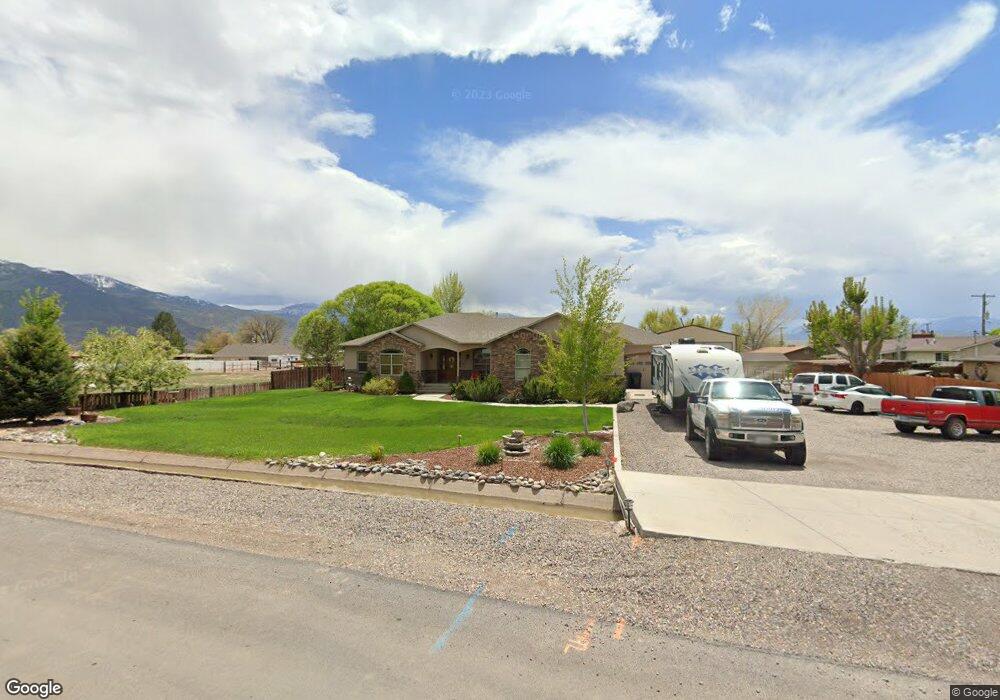
330 E 100 N Elsinore, UT 84724
Estimated Value: $606,681 - $700,000
6
Beds
3
Baths
3,941
Sq Ft
$168/Sq Ft
Est. Value
About This Home
This home is located at 330 E 100 N, Elsinore, UT 84724 and is currently estimated at $661,420, approximately $167 per square foot. 330 E 100 N is a home located in Sevier County with nearby schools including Monroe School, South Sevier Middle School, and South Sevier High School.
Ownership History
Date
Name
Owned For
Owner Type
Purchase Details
Closed on
Feb 1, 2016
Sold by
Roberts James Leonard
Bought by
Gallegos Wesley
Current Estimated Value
Home Financials for this Owner
Home Financials are based on the most recent Mortgage that was taken out on this home.
Original Mortgage
$237,405
Outstanding Balance
$187,677
Interest Rate
3.94%
Mortgage Type
New Conventional
Estimated Equity
$473,743
Purchase Details
Closed on
Dec 2, 2010
Sold by
Corpron Kay
Bought by
Roberts James Leonard and Leonard And Arline Roberts Living Trust
Purchase Details
Closed on
Nov 11, 2010
Sold by
State Bank Of Southern Utah
Bought by
Kenyon Kay Corpron
Purchase Details
Closed on
Nov 10, 2010
Sold by
Kenyon Kay Corpron
Bought by
Corpron Kay and The Kay Corpron Living Trust
Purchase Details
Closed on
Nov 9, 2005
Sold by
Christensen Ramon N and Christensen Lynn P
Bought by
Anderson Rodney D and Anderson Jessie L
Create a Home Valuation Report for This Property
The Home Valuation Report is an in-depth analysis detailing your home's value as well as a comparison with similar homes in the area
Purchase History
| Date | Buyer | Sale Price | Title Company |
|---|---|---|---|
| Gallegos Wesley | -- | First American Title Insuran | |
| Roberts James Leonard | -- | -- | |
| Kenyon Kay Corpron | -- | -- | |
| Corpron Kay | -- | -- | |
| Anderson Rodney D | -- | Utah Title & Abstract |
Source: Public Records
Mortgage History
| Date | Status | Borrower | Loan Amount |
|---|---|---|---|
| Open | Gallegos Wesley | $237,405 |
Source: Public Records
Tax History
| Year | Tax Paid | Tax Assessment Tax Assessment Total Assessment is a certain percentage of the fair market value that is determined by local assessors to be the total taxable value of land and additions on the property. | Land | Improvement |
|---|---|---|---|---|
| 2025 | $3,326 | $385,170 | $36,050 | $349,120 |
| 2024 | $3,326 | $404,650 | $29,535 | $375,115 |
| 2023 | $3,567 | $395,931 | $27,312 | $368,619 |
| 2022 | $2,574 | $254,037 | $23,330 | $230,707 |
| 2021 | $2,657 | $216,858 | $19,474 | $197,384 |
| 2020 | $2,440 | $186,522 | $12,172 | $174,350 |
| 2019 | $2,247 | $183,060 | $12,170 | $170,890 |
| 2018 | $2,352 | $170,400 | $12,170 | $158,230 |
| 2017 | $2,291 | $158,880 | $12,170 | $146,710 |
| 2016 | $1,781 | $156,430 | $0 | $0 |
| 2015 | $1,781 | $156,430 | $0 | $0 |
| 2014 | $1,781 | $156,430 | $0 | $0 |
Source: Public Records
Map
Nearby Homes
- 272 N 350 E
- 1075 S 800 E
- 125 S Center St
- 45 S 200 W
- 851 N 280 E
- 408 S Center St
- 1025 S 800 E
- 76 S Sr 118
- 50 E 1570 N Unit 3
- 1103 N Brooklyn Rd
- 986 E 2290 N
- 91 W 100 S
- 80 N 200 W
- 190 S Main St
- 1157 E 2350 N Unit 1
- 871 N Brooklyn Rd
- 2091 N 1200 E Unit 14
- 0 E Landslide Rd Unit 1
- 630 N Main St
- 323 W 400 N
Your Personal Tour Guide
Ask me questions while you tour the home.