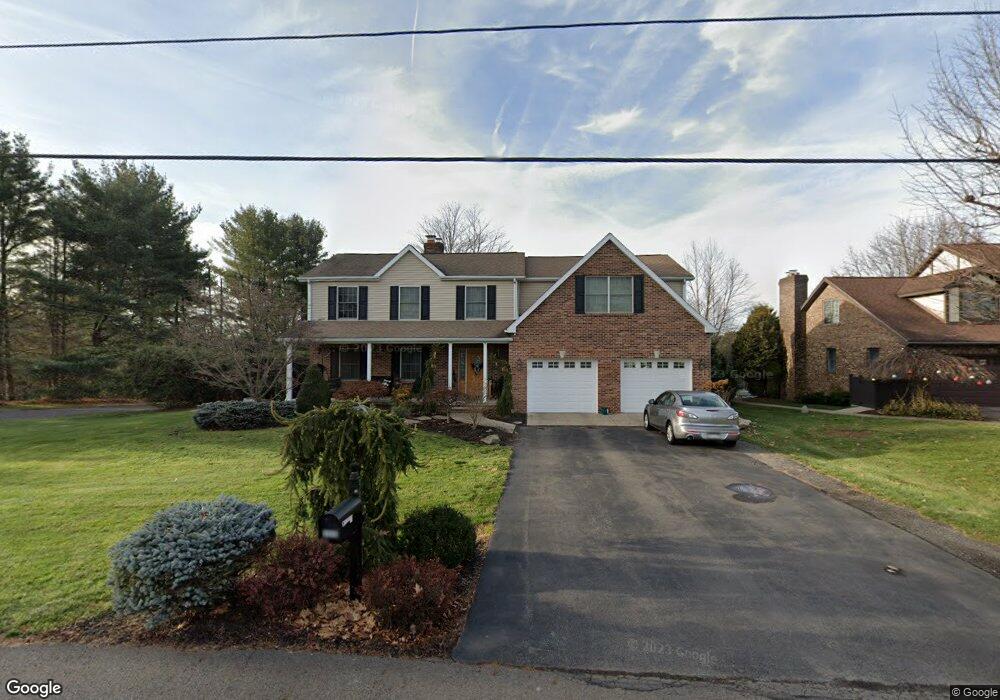
330 Howell Rd Shavertown, PA 18708
Estimated Value: $307,306 - $557,000
Studio
--
Bath
1,922
Sq Ft
$196/Sq Ft
Est. Value
About This Home
This home is located at 330 Howell Rd, Shavertown, PA 18708 and is currently estimated at $377,077, approximately $196 per square foot. 330 Howell Rd is a home located in Luzerne County with nearby schools including Dallas Senior High School.
Ownership History
Date
Name
Owned For
Owner Type
Purchase Details
Closed on
Jul 11, 2020
Sold by
Kotch Mary Jean and Congdon Melvin
Bought by
Congdon Karen and Howe Karen
Current Estimated Value
Home Financials for this Owner
Home Financials are based on the most recent Mortgage that was taken out on this home.
Original Mortgage
$260,000
Outstanding Balance
$230,551
Interest Rate
3.1%
Mortgage Type
New Conventional
Estimated Equity
$146,526
Purchase Details
Closed on
Jul 25, 2000
Bought by
Congdon Melvin
Create a Home Valuation Report for This Property
The Home Valuation Report is an in-depth analysis detailing your home's value as well as a comparison with similar homes in the area
Home Values in the Area
Average Home Value in this Area
Purchase History
| Date | Buyer | Sale Price | Title Company |
|---|---|---|---|
| Congdon Karen | -- | Revere Title | |
| Congdon Melvin | $122,000 | -- |
Source: Public Records
Mortgage History
| Date | Status | Borrower | Loan Amount |
|---|---|---|---|
| Open | Congdon Karen | $260,000 |
Source: Public Records
Tax History
| Year | Tax Paid | Tax Assessment Tax Assessment Total Assessment is a certain percentage of the fair market value that is determined by local assessors to be the total taxable value of land and additions on the property. | Land | Improvement |
|---|---|---|---|---|
| 2025 | $3,972 | $183,400 | $42,300 | $141,100 |
| 2024 | $3,849 | $183,400 | $42,300 | $141,100 |
| 2023 | $3,849 | $183,400 | $42,300 | $141,100 |
| 2022 | $3,815 | $183,400 | $42,300 | $141,100 |
| 2021 | $3,815 | $183,400 | $42,300 | $141,100 |
| 2020 | $3,815 | $183,400 | $42,300 | $141,100 |
| 2019 | $3,780 | $183,400 | $42,300 | $141,100 |
| 2018 | $3,743 | $183,400 | $42,300 | $141,100 |
| 2017 | $3,689 | $183,400 | $42,300 | $141,100 |
| 2016 | -- | $183,400 | $42,300 | $141,100 |
| 2015 | $3,048 | $183,400 | $42,300 | $141,100 |
| 2014 | $3,048 | $183,400 | $42,300 | $141,100 |
Source: Public Records
Map
Nearby Homes
- 235 E Center St
- 31 Hilltop Dr
- 7 Echo Valley Dr
- 39 Cardinal Dr
- 18 Louise Rd
- 1021 Lower Demunds Rd
- 1000 Lower Demunds Rd
- 695 Main St
- 35 E Franklin St
- 36 Longdale Ave
- 680 Main Rd
- 0 Main St
- 65 Shaver Ave
- 0 Lt Michael Cleary Dr
- 175 N Pioneer Ave
- 209 Terrace Ave
- 3 N Pioneer Ave
- 747 Greens
- 0 Grandview Ave
- Lot # 4 Pioneer Ave
- 334 Howell Rd
- 180 Limewood Rd
- 338 Howell Rd
- 122 S Legend Rd
- 181 Limewood Rd
- 339 Howell Rd
- 342 Howell Rd
- 325 Howell Rd
- 176 Limewood Rd
- 177 Limewood Rd
- 324 Howell Rd
- 341 Howell Rd
- 328 Howell Rd
- 170 Limewood Rd
- 343 Howell Rd
- 319 Howell Rd
- 180 Butternut Rd
- 348 Howell Rd
- 184 Butternut Rd
- 164 Butternut Rd
Your Personal Tour Guide
Ask me questions while you tour the home.