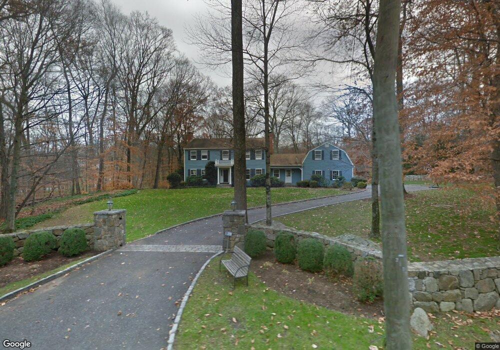
330 Laurel Rd New Canaan, CT 06840
Estimated Value: $2,434,000 - $3,578,000
4
Beds
4
Baths
4,344
Sq Ft
$652/Sq Ft
Est. Value
About This Home
This home is located at 330 Laurel Rd, New Canaan, CT 06840 and is currently estimated at $2,831,087, approximately $651 per square foot. 330 Laurel Rd is a home located in Fairfield County with nearby schools including East Elementary School, Saxe Middle School, and New Canaan High School.
Ownership History
Date
Name
Owned For
Owner Type
Purchase Details
Closed on
Dec 22, 2015
Sold by
Tate Christopher G and Tate Lauren C
Bought by
Tate Christopher G and Tate Lauren C
Current Estimated Value
Purchase Details
Closed on
Nov 29, 2007
Sold by
Reals Jeffrey A and Reals Linda C
Bought by
Tate Christopher G and Tate Lauren C
Purchase Details
Closed on
Mar 2, 2004
Sold by
Sihpol 3Rd Theodore C and Sihpol Rhonda J
Bought by
Reals Jeffrey A and Reals Linda C
Purchase Details
Closed on
Jul 11, 2003
Sold by
Lyman Scott T and Lyman Cynthia A
Bought by
Sihpol Theodore C and Sihpol Rhonda J
Purchase Details
Closed on
May 28, 1996
Sold by
Wyker Elizabeth E
Bought by
Lyman Scott T and Lyman Cynthia A
Create a Home Valuation Report for This Property
The Home Valuation Report is an in-depth analysis detailing your home's value as well as a comparison with similar homes in the area
Home Values in the Area
Average Home Value in this Area
Purchase History
| Date | Buyer | Sale Price | Title Company |
|---|---|---|---|
| Tate Christopher G | -- | -- | |
| Tate Christopher G | $1,800,000 | -- | |
| Reals Jeffrey A | $1,650,000 | -- | |
| Sihpol Theodore C | $1,701,150 | -- | |
| Lyman Scott T | $725,000 | -- |
Source: Public Records
Mortgage History
| Date | Status | Borrower | Loan Amount |
|---|---|---|---|
| Open | Lyman Scott T | $792,792 | |
| Previous Owner | Lyman Scott T | $1,118,477 |
Source: Public Records
Tax History Compared to Growth
Tax History
| Year | Tax Paid | Tax Assessment Tax Assessment Total Assessment is a certain percentage of the fair market value that is determined by local assessors to be the total taxable value of land and additions on the property. | Land | Improvement |
|---|---|---|---|---|
| 2025 | $22,652 | $1,357,230 | $582,750 | $774,480 |
| 2024 | $21,906 | $1,357,230 | $582,750 | $774,480 |
| 2023 | $20,640 | $1,089,760 | $523,880 | $565,880 |
| 2022 | $19,510 | $1,062,040 | $523,880 | $538,160 |
| 2021 | $19,287 | $1,062,040 | $523,880 | $538,160 |
| 2020 | $16,721 | $920,780 | $523,880 | $396,900 |
| 2019 | $16,795 | $920,780 | $523,880 | $396,900 |
| 2018 | $18,311 | $1,079,680 | $554,330 | $525,350 |
| 2017 | $17,942 | $1,076,320 | $554,330 | $521,990 |
| 2016 | $17,555 | $1,076,320 | $554,330 | $521,990 |
| 2015 | $17,210 | $1,076,320 | $554,330 | $521,990 |
| 2014 | $16,726 | $1,076,320 | $554,330 | $521,990 |
Source: Public Records
Map
Nearby Homes
- 760 Valley Rd
- 561 Smith Ridge Rd
- 650 Laurel Rd
- 114 Ferris Hill Rd
- 199 Mariomi Rd
- 122 Brookwood Ln
- 439 Cheese Spring Rd
- 48 Brookwood Ln
- 44 Benedict Hill Rd
- 22 Father Peters Ln
- 30L Huckleberry Hill Rd
- 240 Rosebrook Rd
- 30 Wild Duck Rd
- 531L N Wilton Rd
- 469L N Wilton Rd
- 469, 531,533 N Wilton Rd
- 62 Summersweet Ln
- 533L N Wilton Rd
- 565 Oenoke Ridge
- 262 Brushy Ridge Rd