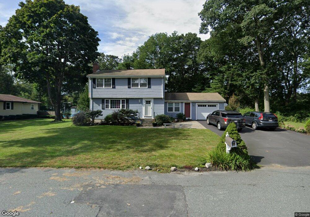
330 Marked Tree Rd Holliston, MA 01746
Estimated Value: $708,005 - $793,000
4
Beds
2
Baths
1,824
Sq Ft
$414/Sq Ft
Est. Value
About This Home
This home is located at 330 Marked Tree Rd, Holliston, MA 01746 and is currently estimated at $754,251, approximately $413 per square foot. 330 Marked Tree Rd is a home located in Middlesex County with nearby schools including Placentino Elementary School, Miller Elementary School, and Robert H. Adams Middle School.
Ownership History
Date
Name
Owned For
Owner Type
Purchase Details
Closed on
Sep 30, 2005
Sold by
Spencer Frederick and Slaven Marissa
Bought by
Scaramella Emily and Scaramella Jed
Current Estimated Value
Home Financials for this Owner
Home Financials are based on the most recent Mortgage that was taken out on this home.
Original Mortgage
$336,000
Outstanding Balance
$180,748
Interest Rate
5.84%
Mortgage Type
Purchase Money Mortgage
Estimated Equity
$573,503
Purchase Details
Closed on
Sep 1, 1998
Sold by
Raudonis Walter J and Hyde Pat S
Bought by
Spencer Frederick and Slaven Marissa
Home Financials for this Owner
Home Financials are based on the most recent Mortgage that was taken out on this home.
Original Mortgage
$217,194
Interest Rate
6.9%
Mortgage Type
Purchase Money Mortgage
Purchase Details
Closed on
Jul 30, 1993
Sold by
Haynes George M
Bought by
Raudonis Walter J and Hyde Pat S
Home Financials for this Owner
Home Financials are based on the most recent Mortgage that was taken out on this home.
Original Mortgage
$165,000
Interest Rate
7.32%
Mortgage Type
Purchase Money Mortgage
Create a Home Valuation Report for This Property
The Home Valuation Report is an in-depth analysis detailing your home's value as well as a comparison with similar homes in the area
Home Values in the Area
Average Home Value in this Area
Purchase History
| Date | Buyer | Sale Price | Title Company |
|---|---|---|---|
| Scaramella Emily | $420,000 | -- | |
| Spencer Frederick | $244,500 | -- | |
| Raudonis Walter J | $207,100 | -- |
Source: Public Records
Mortgage History
| Date | Status | Borrower | Loan Amount |
|---|---|---|---|
| Open | Scaramella Emily | $336,000 | |
| Previous Owner | Raudonis Walter J | $217,194 | |
| Previous Owner | Raudonis Walter J | $165,000 |
Source: Public Records
Tax History Compared to Growth
Tax History
| Year | Tax Paid | Tax Assessment Tax Assessment Total Assessment is a certain percentage of the fair market value that is determined by local assessors to be the total taxable value of land and additions on the property. | Land | Improvement |
|---|---|---|---|---|
| 2025 | $8,838 | $603,300 | $257,200 | $346,100 |
| 2024 | $7,973 | $529,400 | $257,200 | $272,200 |
| 2023 | $7,863 | $510,600 | $257,200 | $253,400 |
| 2022 | $7,894 | $454,200 | $257,200 | $197,000 |
| 2021 | $7,895 | $442,300 | $245,300 | $197,000 |
| 2020 | $7,536 | $399,800 | $221,300 | $178,500 |
| 2019 | $7,368 | $391,300 | $214,800 | $176,500 |
| 2018 | $7,306 | $391,300 | $214,800 | $176,500 |
| 2017 | $7,575 | $409,000 | $219,200 | $189,800 |
| 2016 | $6,939 | $369,300 | $188,300 | $181,000 |
| 2015 | $6,502 | $335,500 | $153,700 | $181,800 |
Source: Public Records
Map
Nearby Homes
- 1014 Highland St
- 43 Bittersweet Cir Unit 43
- 1366 Washington St
- 1037 Washington St
- 160 Winter St
- 54 Westfield Dr
- 75 Ridge Rd
- 156 Mitchell Rd
- 150 Westfield Dr
- 195 High St
- 32 Colonial Way
- 133 Brooksmont Dr Unit 43
- 1 Danforth Dr
- 131 Jennings Rd
- 59 Turner Rd
- 152 Turner Rd Unit 43
- 152 Turner Rd Unit 14
- 147 Turner Rd Unit 80
- 7 Hill St
- 625 Norfolk St
- 320 Marked Tree Rd
- 49 Greenview Dr
- 331 Marked Tree Rd
- 319 Marked Tree Rd
- 310 Marked Tree Rd
- 300 Marked Tree Rd
- 43 Greenview Dr
- 88 Greenview Dr
- 127 Robin Hill Rd
- 116 Robin Hill Rd
- 295 Marked Tree Rd
- 35 Greenview Dr
- 290 Marked Tree Rd
- 80 Greenview Dr
- 66 Greenview Dr
- 283 Marked Tree Rd
- 98 Robin Hill Rd
- 280 Marked Tree Rd
- 115 Robin Hill Rd
- 52 Greenview Dr