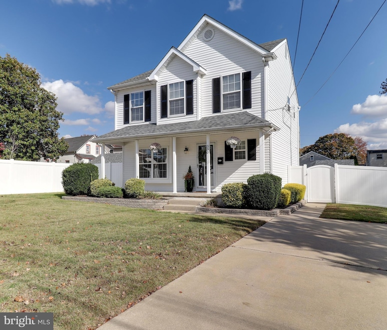
330 Price Ave Glendora, NJ 08029
Estimated payment $2,856/month
Highlights
- A-Frame Home
- Attic
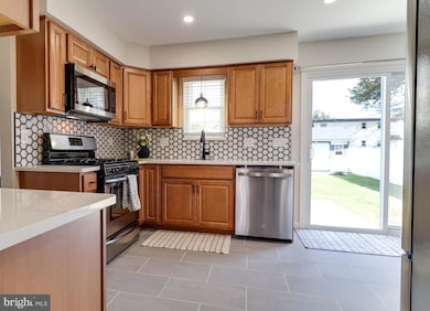
- Upgraded Countertops
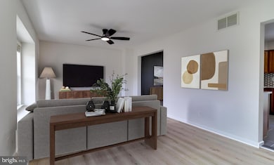
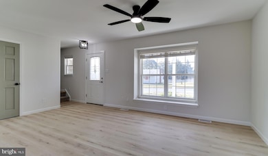
- Wood Flooring
- No HOA
- Breakfast Area or Nook
About This Home
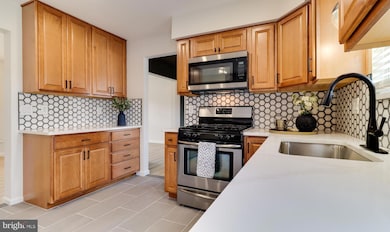
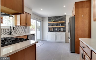
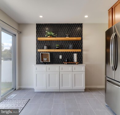
Welcome to 330 Price Ave! This beautifully remodeled home is move-in ready and perfect for your next chapter. From the moment you arrive, the impressive curb appeal sets the tone. Inside, you’ll find brand new LVP flooring, a stylish powder room, and a bright, open living space. The kitchen is a true showstopper—featuring quartz countertops, tile backsplash, and flooring, plus a versatile dry bar with added cabinetry and shelving. The adjacent dining area is perfect for gatherings, and the huge backyard offers endless possibilities. Upstairs, discover three spacious bedrooms, including a primary suite with a walk-in closet, and a stunning full bath with high-end finishes and attention to detail. The fully finished basement adds even more living space, along with updated utilities and laundry. Don’t miss your chance to call this beautiful home yours—schedule a tour today

Home Details
Home Type
- Single Family
Est. Annual Taxes
- $8,979
Year Built
- Built in 1991 | Remodeled in 2025
Lot Details
- 7,188 Sq Ft Lot
- Lot Dimensions are 57.50 x 125.00
- Property is in excellent condition
Parking
- Driveway
Home Design
- A-Frame Home
- Block Foundation
- Vinyl Siding
Interior Spaces
- 1,306 Sq Ft Home
- Property has 2 Levels
- Wet Bar
- Ceiling Fan
- Recessed Lighting
- Formal Dining Room
- Wood Flooring
- Basement Fills Entire Space Under The House
- Attic Fan
Kitchen
- Breakfast Area or Nook
- Eat-In Kitchen
- Upgraded Countertops
Bedrooms and Bathrooms
- 3 Bedrooms
- Walk-In Closet
- Bathtub with Shower
Accessible Home Design
- More Than Two Accessible Exits
Utilities
- 90% Forced Air Heating and Cooling System
- Cooling System Utilizes Natural Gas
- Natural Gas Water Heater
Community Details
- No Home Owners Association
Listing and Financial Details
- Tax Lot 00017
- Assessor Parcel Number 15-01803-00017
Map
Home Values in the Area
Average Home Value in this Area
Tax History
| Year | Tax Paid | Tax Assessment Tax Assessment Total Assessment is a certain percentage of the fair market value that is determined by local assessors to be the total taxable value of land and additions on the property. | Land | Improvement |
|---|---|---|---|---|
| 2025 | $8,824 | $208,800 | $51,400 | $157,400 |
| 2024 | $8,529 | $208,800 | $51,400 | $157,400 |
| 2023 | $8,529 | $208,800 | $51,400 | $157,400 |
| 2022 | $8,484 | $208,800 | $51,400 | $157,400 |
| 2021 | $8,306 | $208,800 | $51,400 | $157,400 |
| 2020 | $8,312 | $208,800 | $51,400 | $157,400 |
| 2019 | $8,129 | $208,800 | $51,400 | $157,400 |
| 2018 | $8,093 | $208,800 | $51,400 | $157,400 |
| 2017 | $9,429 | $208,800 | $51,400 | $157,400 |
| 2016 | $7,659 | $208,800 | $51,400 | $157,400 |
| 2015 | $7,110 | $208,800 | $51,400 | $157,400 |
| 2014 | $7,068 | $208,800 | $51,400 | $157,400 |
Property History
| Date | Event | Price | List to Sale | Price per Sq Ft |
|---|---|---|---|---|
| 10/26/2025 10/26/25 | For Sale | $400,000 | -- | $306 / Sq Ft |
Purchase History
| Date | Type | Sale Price | Title Company |
|---|---|---|---|
| Deed | $275,000 | Spire Abstract | |
| Deed | $121,900 | -- |
Mortgage History
| Date | Status | Loan Amount | Loan Type |
|---|---|---|---|
| Open | $285,000 | Construction | |
| Previous Owner | $121,830 | FHA |
Source: Bright MLS
MLS Number: NJCD2104894
APN: 15-01803-0000-00017
Disclaimer: Certain information contained herein is derived from information provided by parties other than Homes.com. All information provided is deemed reliable, but is not guaranteed to be accurate and should be independently verified.
![]() The data relating to real estate for sale on this website appears in part through the BRIGHT Internet Data Exchange program, a voluntary cooperative exchange of property listing data between licensed real estate brokerage firms, and is provided by BRIGHT through a licensing agreement.
The data relating to real estate for sale on this website appears in part through the BRIGHT Internet Data Exchange program, a voluntary cooperative exchange of property listing data between licensed real estate brokerage firms, and is provided by BRIGHT through a licensing agreement.
Listing information is from various brokers who participate in the Bright MLS IDX program and not all listings may be visible on the site.
The property information being provided on or through the website is for the personal, non-commercial use of consumers and such information may not be used for any purpose other than to identify prospective properties consumers may be interested in purchasing.
Some properties which appear for sale on the website may no longer be available because they are for instance, under contract, sold or are no longer being offered for sale.
Property information displayed is deemed reliable but is not guaranteed.
Copyright 2025 Bright MLS, Inc.
- 418 Lake Ave
- 310 Ridge Ave
- 219 Black Horse Pike
- 700 N Black Horse Pike Unit D
- 700 N Black Horse Pike
- 30 12th Ave
- 1109 San Jose Dr
- 590 Lower Landing Rd
- 590 Lower Landing Rd
- 1302 N Black Horse Pike
- 1501 Old Blackhorse Pike
- 1424 Boxwood Dr
- 21 W 2nd Ave
- 300 Bowers Ave
- 628 Chatham Rd
- 424 N Black Horse Pike Unit 470
- 171 Pine Ave Unit A
- 540 N Read Ave
- 29 Whaler Dr
- 7 Reagan Dr