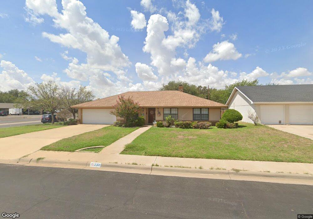
3301 Lanham St Midland, TX 79705
Estimated Value: $265,017 - $319,000
--
Bed
2
Baths
1,880
Sq Ft
$160/Sq Ft
Est. Value
About This Home
This home is located at 3301 Lanham St, Midland, TX 79705 and is currently estimated at $300,754, approximately $159 per square foot. 3301 Lanham St is a home located in Midland County with nearby schools including Midland High School, Robert H. Goddard Junior High School, and The Hillander School.
Ownership History
Date
Name
Owned For
Owner Type
Purchase Details
Closed on
Oct 11, 2024
Sold by
Owens Linda Dianne
Bought by
Owens Linda Dianne and Stringer Carol Ceree
Current Estimated Value
Purchase Details
Closed on
Sep 30, 1999
Sold by
Ford James Henry
Bought by
Owens Linda D
Purchase Details
Closed on
Mar 31, 1993
Bought by
Owens Linda D
Purchase Details
Closed on
Jan 23, 1990
Bought by
Owens Linda D
Purchase Details
Closed on
Jun 1, 1986
Bought by
Owens Linda D
Purchase Details
Closed on
Nov 14, 1978
Bought by
Owens Linda D
Create a Home Valuation Report for This Property
The Home Valuation Report is an in-depth analysis detailing your home's value as well as a comparison with similar homes in the area
Home Values in the Area
Average Home Value in this Area
Purchase History
| Date | Buyer | Sale Price | Title Company |
|---|---|---|---|
| Owens Linda Dianne | -- | None Listed On Document | |
| Owens Linda D | -- | -- | |
| Owens Linda D | -- | -- | |
| Owens Linda D | -- | -- | |
| Owens Linda D | -- | -- | |
| Owens Linda D | -- | -- |
Source: Public Records
Tax History Compared to Growth
Tax History
| Year | Tax Paid | Tax Assessment Tax Assessment Total Assessment is a certain percentage of the fair market value that is determined by local assessors to be the total taxable value of land and additions on the property. | Land | Improvement |
|---|---|---|---|---|
| 2025 | $1,233 | $346,240 | $16,460 | $329,780 |
| 2024 | $1,238 | $226,160 | $16,460 | $209,700 |
| 2023 | $1,133 | $210,780 | $16,460 | $194,320 |
| 2022 | $3,147 | $201,440 | $16,460 | $184,980 |
| 2021 | $3,922 | $225,120 | $16,460 | $208,660 |
| 2020 | $2,317 | $212,090 | $16,460 | $195,630 |
| 2019 | $3,999 | $211,240 | $16,460 | $195,630 |
| 2018 | $3,734 | $192,040 | $16,460 | $175,580 |
| 2017 | $3,633 | $186,840 | $16,460 | $170,380 |
| 2016 | $3,493 | $187,310 | $16,460 | $170,850 |
| 2015 | -- | $187,310 | $16,460 | $170,850 |
| 2014 | -- | $174,710 | $16,460 | $158,250 |
Source: Public Records
Map
Nearby Homes
- 63 Ironwood Ct Unit 91
- 63 Ironwood Ct
- 2605 Inwood Ct
- 2406 Dartmouth Dr
- 2505 Maxwell Dr
- 5 Chatham Ct
- 2400 W Dengar Ave
- 2409 Stutz Place
- 19 Winchester Ct
- 2601 W Dengar Ave
- 4 Amhurst Ct
- 2406 Stutz Place
- 2811 Durant Dr
- 2800 Cimmaron Ave
- 2305 Auburn Place
- 2205 Cimmaron Ave
- 2400 Metz Ct
- 3 Marinor Ct
- 2817 Maxwell Dr
- 2806 Auburn Dr
- 3303 Lanham St
- 2500 Quail Point
- 2502 Quail Point
- 3305 Lanham St
- 3302 Lanham St
- 2501 W Wadley Ave
- 2504 Quail Point
- 2505 W Wadley Ave
- 2419 Apperson Dr
- 2500 W Wadley Ave
- 2413 W Wadley Ave
- 3307 Lanham St
- 2509 W Wadley Ave
- 2506 Quail Point
- 2502 W Wadley Ave
- 2511 Quail Point
- 2411 W Wadley Ave
- 2417 Apperson Dr
- 2513 W Wadley Ave
- 2500 Camarie Ave