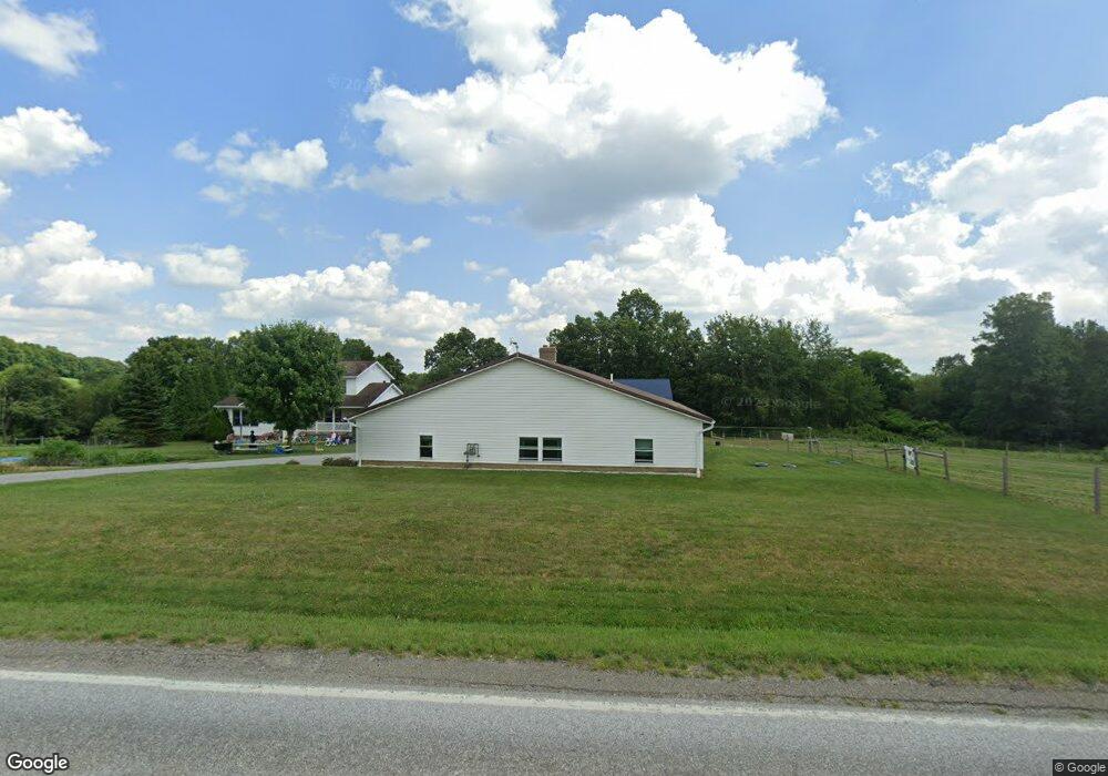
33092 State Route 643 Fresno, OH 43824
Estimated Value: $330,000 - $621,174
5
Beds
2
Baths
2,392
Sq Ft
$193/Sq Ft
Est. Value
About This Home
This home is located at 33092 State Route 643, Fresno, OH 43824 and is currently estimated at $462,725, approximately $193 per square foot. 33092 State Route 643 is a home located in Coshocton County with nearby schools including Garaway High School, Green Ridge School, and White Oak School.
Ownership History
Date
Name
Owned For
Owner Type
Purchase Details
Closed on
May 10, 2022
Sold by
Yoder Monroe Am & Mattie
Bought by
Yoder Joseph M and Yoder Rhoda W
Current Estimated Value
Home Financials for this Owner
Home Financials are based on the most recent Mortgage that was taken out on this home.
Original Mortgage
$337,000
Outstanding Balance
$299,677
Interest Rate
4.52%
Mortgage Type
New Conventional
Estimated Equity
$163,048
Purchase Details
Closed on
Mar 14, 2000
Bought by
Yoder Monroe A M
Create a Home Valuation Report for This Property
The Home Valuation Report is an in-depth analysis detailing your home's value as well as a comparison with similar homes in the area
Home Values in the Area
Average Home Value in this Area
Purchase History
| Date | Buyer | Sale Price | Title Company |
|---|---|---|---|
| Yoder Joseph M | -- | Miller Mast & Mason Ltd | |
| Yoder Monroe A M | $40,800 | -- | |
| Yoder Monroe A M Jl | $40,800 | -- |
Source: Public Records
Mortgage History
| Date | Status | Borrower | Loan Amount |
|---|---|---|---|
| Open | Yoder Joseph M | $337,000 |
Source: Public Records
Tax History Compared to Growth
Tax History
| Year | Tax Paid | Tax Assessment Tax Assessment Total Assessment is a certain percentage of the fair market value that is determined by local assessors to be the total taxable value of land and additions on the property. | Land | Improvement |
|---|---|---|---|---|
| 2024 | $7,893 | $191,730 | $37,840 | $153,890 |
| 2023 | $7,893 | $156,933 | $27,027 | $129,906 |
| 2022 | $5,065 | $117,257 | $27,027 | $90,230 |
| 2021 | $5,198 | $117,257 | $27,027 | $90,230 |
| 2020 | $4,465 | $98,172 | $21,207 | $76,965 |
| 2019 | $4,486 | $98,172 | $21,207 | $76,965 |
| 2018 | $4,070 | $98,172 | $21,207 | $76,965 |
| 2017 | $4,005 | $95,333 | $17,325 | $78,008 |
| 2016 | $3,824 | $95,333 | $17,325 | $78,008 |
| 2015 | $1,927 | $95,333 | $17,325 | $78,008 |
| 2014 | $2,281 | $55,286 | $9,800 | $45,486 |
Source: Public Records
Map
Nearby Homes
- 31509 Township Road 227
- 0 Township Road 219
- 0 Township Road 219
- 32469 Township Road 219
- 31705 Township Road 236
- 30945 County Road 126
- 310 S Butler St
- 204 S Butler St
- 306 N Butler St
- 220 E Main St
- 0 Dunker Rd
- 0 Tr-88 Unit 5165275
- 29466 Ohio 93
- 54972 Township Road 90
- 0 State Rd 93 Unit 23494832
- 10624 Hilltop Rd
- 28427 Ohio 83
- 118 Bern Dr
- 7616 Zurich Dr
- 1743 W Buckhorn Dr
- 33128 State Route 643
- 33024 State Route 643
- 33219 State Route 643
- 51450 Tr 220
- 33369 State Route 643
- 32824 State Route 643
- 51400 Tr 220
- 51286 Tr 220
- 33442 State Route 643
- 33037 County Road 10
- 32981 County Road 10
- 51579 Township Road 214b
- 32863 County Road 10
- 32715 County Road 10
- 32918 County Road 10
- 33034 County Road 10
- 32563 County Road 10
- 32870 County Road 10
- 33187 County Road 10
- 33319 County Road 10