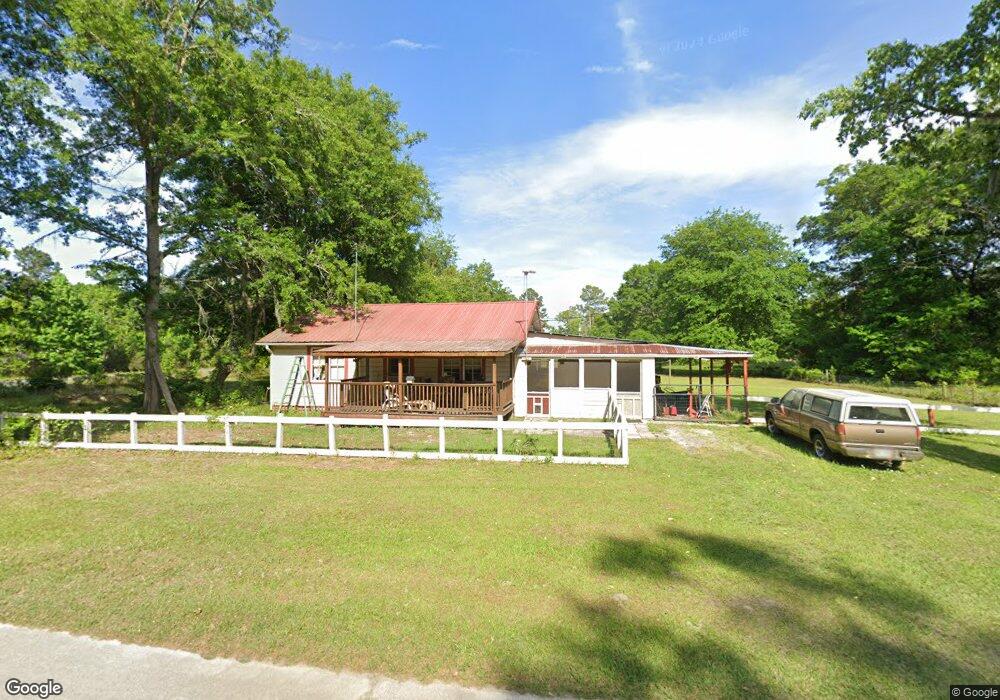
331 Browntown Rd Kingsland, GA 31548
Estimated Value: $136,266 - $219,000
2
Beds
1
Bath
984
Sq Ft
$169/Sq Ft
Est. Value
About This Home
This home is located at 331 Browntown Rd, Kingsland, GA 31548 and is currently estimated at $166,567, approximately $169 per square foot. 331 Browntown Rd is a home located in Camden County with nearby schools including Kingsland Elementary School, Camden Middle School, and Camden County High School.
Ownership History
Date
Name
Owned For
Owner Type
Purchase Details
Closed on
Jun 14, 2005
Sold by
Mcwhorter Christopher M
Bought by
Lester Michael W
Current Estimated Value
Home Financials for this Owner
Home Financials are based on the most recent Mortgage that was taken out on this home.
Original Mortgage
$55,782
Outstanding Balance
$28,561
Interest Rate
5.66%
Mortgage Type
VA
Estimated Equity
$138,006
Create a Home Valuation Report for This Property
The Home Valuation Report is an in-depth analysis detailing your home's value as well as a comparison with similar homes in the area
Home Values in the Area
Average Home Value in this Area
Purchase History
| Date | Buyer | Sale Price | Title Company |
|---|---|---|---|
| Lester Michael W | $54,000 | -- |
Source: Public Records
Mortgage History
| Date | Status | Borrower | Loan Amount |
|---|---|---|---|
| Open | Lester Michael W | $55,782 |
Source: Public Records
Tax History Compared to Growth
Tax History
| Year | Tax Paid | Tax Assessment Tax Assessment Total Assessment is a certain percentage of the fair market value that is determined by local assessors to be the total taxable value of land and additions on the property. | Land | Improvement |
|---|---|---|---|---|
| 2025 | $376 | $47,221 | $10,440 | $36,781 |
| 2024 | $393 | $40,692 | $3,911 | $36,781 |
| 2023 | $405 | $41,384 | $4,603 | $36,781 |
| 2022 | $399 | $25,741 | $4,603 | $21,138 |
| 2021 | $422 | $18,699 | $1,905 | $16,794 |
| 2020 | $434 | $17,763 | $1,905 | $15,858 |
| 2019 | $437 | $17,763 | $1,905 | $15,858 |
| 2018 | $393 | $17,763 | $1,905 | $15,858 |
| 2017 | $372 | $16,053 | $1,905 | $14,148 |
| 2016 | $340 | $15,116 | $1,905 | $13,211 |
| 2015 | $330 | $15,116 | $1,905 | $13,211 |
| 2014 | $332 | $15,228 | $2,017 | $13,211 |
Source: Public Records
Map
Nearby Homes
- 4241 Oakhill Church Rd
- 856 River Landing Dr
- 886 River Landing Dr
- 223 Bulkhead Dr
- 303 Bulkhead Dr
- The Camilla Plan at Northshore - St. Marys River
- The Athens + Bonus Room Plan at Northshore - St. Marys River
- The Gwinnett Plan at Northshore - St. Marys River
- The Savannah Plan at Northshore - St. Marys River
- The Wilmington Plan at Northshore - St. Marys River
- The Brookhaven Plan at Northshore - St. Marys River
- The Dalton Plan at Northshore - St. Marys River
- The Roswell Plan at Northshore - St. Marys River
- The Madison Plan at Northshore - St. Marys River
- The Grayson Plan at Northshore - St. Marys River
- The Stonecrest Plan at Northshore - St. Marys River
- The Hatteras Plan at Northshore - St. Marys River
- 120 Bulkhead Dr
- 109 Wave Break Ct
- 102 Oxbow Ct