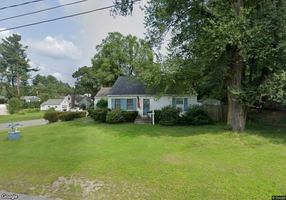
331 Maple St West Boylston, MA 01583
Estimated Value: $396,563 - $512,000
2
Beds
1
Bath
1,090
Sq Ft
$402/Sq Ft
Est. Value
About This Home
This home is located at 331 Maple St, West Boylston, MA 01583 and is currently estimated at $438,141, approximately $401 per square foot. 331 Maple St is a home located in Worcester County with nearby schools including Major Edwards Elementary School, West Boylston Junior/Senior High School, and Abby Kelley Foster Charter Public School.
Ownership History
Date
Name
Owned For
Owner Type
Purchase Details
Closed on
Sep 9, 2008
Sold by
Robillard Steven L
Bought by
Robillard Cinthia L and Robillard Steven L
Current Estimated Value
Purchase Details
Closed on
Sep 12, 1997
Sold by
Mackenzie Steven and Mackenzie Kennilyn
Bought by
Robillard Steven L
Home Financials for this Owner
Home Financials are based on the most recent Mortgage that was taken out on this home.
Original Mortgage
$62,000
Interest Rate
7.31%
Mortgage Type
Purchase Money Mortgage
Create a Home Valuation Report for This Property
The Home Valuation Report is an in-depth analysis detailing your home's value as well as a comparison with similar homes in the area
Home Values in the Area
Average Home Value in this Area
Purchase History
| Date | Buyer | Sale Price | Title Company |
|---|---|---|---|
| Robillard Cinthia L | -- | -- | |
| Robillard Steven L | $92,000 | -- |
Source: Public Records
Mortgage History
| Date | Status | Borrower | Loan Amount |
|---|---|---|---|
| Previous Owner | Robillard Steven L | $62,000 |
Source: Public Records
Tax History
| Year | Tax Paid | Tax Assessment Tax Assessment Total Assessment is a certain percentage of the fair market value that is determined by local assessors to be the total taxable value of land and additions on the property. | Land | Improvement |
|---|---|---|---|---|
| 2025 | $42 | $299,400 | $107,100 | $192,300 |
| 2024 | $4,016 | $271,700 | $107,100 | $164,600 |
| 2023 | $4,080 | $261,900 | $106,000 | $155,900 |
| 2022 | $3,886 | $219,800 | $106,000 | $113,800 |
| 2021 | $592 | $210,600 | $101,800 | $108,800 |
| 2020 | $566 | $204,000 | $101,800 | $102,200 |
| 2019 | $3,689 | $195,700 | $101,800 | $93,900 |
| 2018 | $805 | $192,400 | $101,800 | $90,600 |
| 2017 | $3,463 | $184,200 | $101,800 | $82,400 |
| 2016 | $3,295 | $178,600 | $94,900 | $83,700 |
| 2015 | $3,241 | $176,700 | $93,900 | $82,800 |
Source: Public Records
Map
Nearby Homes
- 48 Whispering Pine Cir Unit 48
- 740 Burncoat St Unit B
- 1 Highland Ave
- 156 Hillside Village Dr
- 71 Hillside Village Dr
- 7 Alpine Dr
- 1110 W Boylston St Unit A
- 10 Beale St
- 69 Santoro Rd
- 31 Danielles Way
- 22 Danielles Way
- 26 Danielles Way
- 30 Osgood Ave
- 53 Collins St
- 39 Mountainshire Dr
- 21 Wyoming Dr
- 13 Fatima Ln
- 30 Danielles Way
- 66 Eunice Ave
- 331 Burncoat St
Your Personal Tour Guide
Ask me questions while you tour the home.