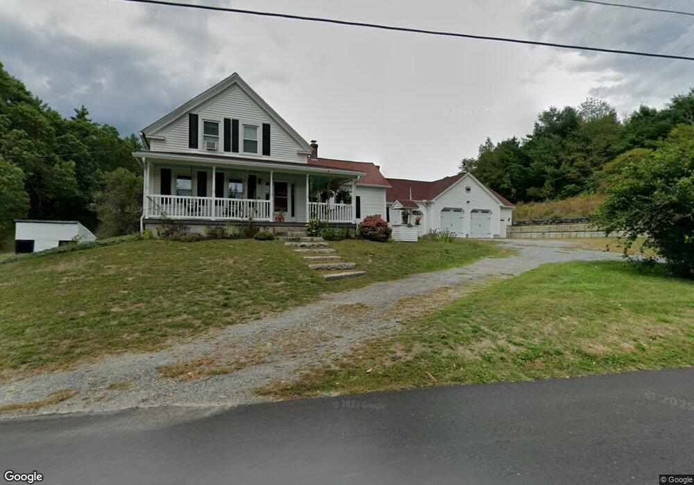
331 Mulpus Rd Lunenburg, MA 01462
Estimated Value: $637,000 - $889,000
3
Beds
2
Baths
2,082
Sq Ft
$359/Sq Ft
Est. Value
About This Home
This home is located at 331 Mulpus Rd, Lunenburg, MA 01462 and is currently estimated at $747,185, approximately $358 per square foot. 331 Mulpus Rd is a home located in Worcester County with nearby schools including Lunenburg Primary School and Lunenburg High School.
Ownership History
Date
Name
Owned For
Owner Type
Purchase Details
Closed on
Jul 28, 2020
Sold by
Womble-Dewitte Nancy
Bought by
Nancy Womble Dewitte Lt and Womble-Dewitte
Current Estimated Value
Purchase Details
Closed on
Apr 19, 2000
Sold by
Lbk Bldrs Inc
Bought by
Deschenes Stephen and Deschenes Kathryn B
Home Financials for this Owner
Home Financials are based on the most recent Mortgage that was taken out on this home.
Original Mortgage
$251,900
Interest Rate
8.21%
Mortgage Type
Purchase Money Mortgage
Purchase Details
Closed on
May 5, 1999
Sold by
Womble David A and Womble Nancy R
Bought by
Labmik Land Corp
Home Financials for this Owner
Home Financials are based on the most recent Mortgage that was taken out on this home.
Original Mortgage
$365,000
Interest Rate
6.92%
Mortgage Type
Purchase Money Mortgage
Create a Home Valuation Report for This Property
The Home Valuation Report is an in-depth analysis detailing your home's value as well as a comparison with similar homes in the area
Home Values in the Area
Average Home Value in this Area
Purchase History
| Date | Buyer | Sale Price | Title Company |
|---|---|---|---|
| Nancy Womble Dewitte Lt | -- | None Available | |
| Nancy Womble Dewitte Lt | -- | None Available | |
| Nancy Womble Dewitte Lt | -- | None Available | |
| Deschenes Stephen | $279,900 | -- | |
| Lbk Bldrs Inc | $234,900 | -- | |
| Lbk Bldrs Inc | $234,900 | -- | |
| Labmik Land Corp | $140,000 | -- | |
| Labmik Land Corp | $140,000 | -- |
Source: Public Records
Mortgage History
| Date | Status | Borrower | Loan Amount |
|---|---|---|---|
| Previous Owner | Labmik Land Corp | $251,900 | |
| Previous Owner | Labmik Land Corp | $0 | |
| Previous Owner | Labmik Land Corp | $365,000 |
Source: Public Records
Tax History
| Year | Tax Paid | Tax Assessment Tax Assessment Total Assessment is a certain percentage of the fair market value that is determined by local assessors to be the total taxable value of land and additions on the property. | Land | Improvement |
|---|---|---|---|---|
| 2025 | $9,036 | $629,280 | $270,080 | $359,200 |
| 2024 | $7,451 | $528,410 | $182,010 | $346,400 |
| 2023 | $6,906 | $472,400 | $165,300 | $307,100 |
| 2022 | $6,351 | $369,440 | $143,740 | $225,700 |
| 2020 | $6,487 | $358,000 | $142,100 | $215,900 |
| 2019 | $6,361 | $340,500 | $134,200 | $206,300 |
| 2018 | $5,945 | $301,800 | $131,300 | $170,500 |
| 2017 | $5,690 | $284,800 | $125,100 | $159,700 |
| 2016 | $5,471 | $279,000 | $119,500 | $159,500 |
| 2015 | $4,677 | $255,300 | $115,100 | $140,200 |
Source: Public Records
Map
Nearby Homes
- 367 Mulpus Rd
- 146 Elmwood Rd
- 12 Cortland Cir Unit 12
- 167 S Row Rd
- 24 Townsend Rd
- 22 Townsend Rd
- Lot 10 Christian Cir
- 91 Valley Rd
- 92 Squannacook Rd
- Lot 5 Townsend Rd
- 110 Burrage St
- 2 Gabes Place
- 601 Flat Hill Rd
- 44 Squannacook Rd
- 11 Longwood Dr
- 43 Longley Rd
- 35 Leominster Rd
- 36 Gilchrest St
- 11 Longley Rd Unit K8
- 11 Longley Rd Unit G3
Your Personal Tour Guide
Ask me questions while you tour the home.