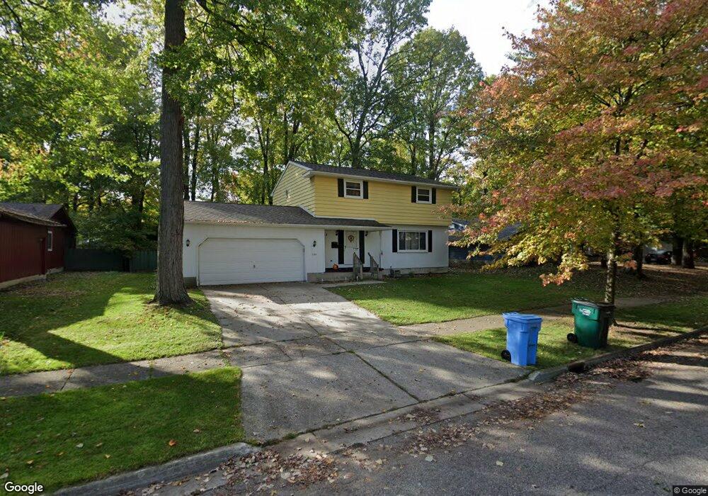
3311 Cardiff Ct Lansing, MI 48911
Averill Woods NeighborhoodEstimated Value: $220,824 - $272,000
4
Beds
3
Baths
1,882
Sq Ft
$132/Sq Ft
Est. Value
About This Home
This home is located at 3311 Cardiff Ct, Lansing, MI 48911 and is currently estimated at $248,206, approximately $131 per square foot. 3311 Cardiff Ct is a home located in Ingham County with nearby schools including Averill Elementary School, Attwood School, and J.W. Sexton High School.
Ownership History
Date
Name
Owned For
Owner Type
Purchase Details
Closed on
May 4, 2016
Sold by
Jacobs Catherine A and Edwards Delbert Joseph
Bought by
Morrice Joel D
Current Estimated Value
Home Financials for this Owner
Home Financials are based on the most recent Mortgage that was taken out on this home.
Original Mortgage
$117,826
Outstanding Balance
$94,434
Interest Rate
3.87%
Mortgage Type
FHA
Estimated Equity
$153,772
Purchase Details
Closed on
Oct 6, 1998
Sold by
Kochanowski Robert E
Bought by
Kochanowski Robert E
Create a Home Valuation Report for This Property
The Home Valuation Report is an in-depth analysis detailing your home's value as well as a comparison with similar homes in the area
Home Values in the Area
Average Home Value in this Area
Purchase History
| Date | Buyer | Sale Price | Title Company |
|---|---|---|---|
| Morrice Joel D | $120,000 | None Available | |
| Kochanowski Robert E | -- | -- |
Source: Public Records
Mortgage History
| Date | Status | Borrower | Loan Amount |
|---|---|---|---|
| Open | Morrice Joel D | $117,826 |
Source: Public Records
Tax History Compared to Growth
Tax History
| Year | Tax Paid | Tax Assessment Tax Assessment Total Assessment is a certain percentage of the fair market value that is determined by local assessors to be the total taxable value of land and additions on the property. | Land | Improvement |
|---|---|---|---|---|
| 2025 | $4,171 | $95,800 | $12,600 | $83,200 |
| 2024 | $33 | $93,200 | $12,600 | $80,600 |
| 2023 | $3,909 | $81,200 | $12,600 | $68,600 |
| 2022 | $3,520 | $74,100 | $12,600 | $61,500 |
| 2021 | $3,447 | $70,700 | $11,900 | $58,800 |
| 2020 | $3,426 | $66,200 | $11,900 | $54,300 |
| 2019 | $3,286 | $59,200 | $11,900 | $47,300 |
| 2018 | $3,077 | $52,600 | $11,900 | $40,700 |
| 2017 | $2,979 | $52,600 | $11,900 | $40,700 |
| 2016 | $2,275 | $46,900 | $11,900 | $35,000 |
| 2015 | $2,275 | $43,100 | $23,745 | $19,355 |
| 2014 | $2,275 | $40,500 | $23,745 | $16,755 |
Source: Public Records
Map
Nearby Homes
- 3200 Lawdor Rd
- 2838 Sunderland Rd
- 0 S Deerfield Ave
- 2905 S Catherine St
- 3212 Ingham St
- 3600 Sandhurst Dr
- 3334 Ingham St
- 2710 Bedford Rd
- 3424 S Catherine St
- 3510 Christine Dr
- 3700 W Holmes Rd
- 3100 Glenbrook Dr
- 3324 Viking St
- 3425 Cooley Dr
- 2800 S Waverly Hwy
- 3330 Avalon St
- 3336 Avalon St
- 4.5 Locust Ln
- 3421 Troon Cir Unit 29
- 2409 Victor Ave