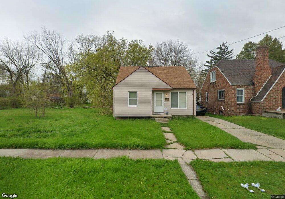
3311 Rust Ave Saginaw, MI 48601
Fairground NeighborhoodEstimated Value: $59,000
--
Bed
--
Bath
1,011
Sq Ft
$58/Sq Ft
Est. Value
About This Home
This home is located at 3311 Rust Ave, Saginaw, MI 48601 and is currently estimated at $59,000, approximately $58 per square foot. 3311 Rust Ave is a home located in Saginaw County with nearby schools including Jessie Loomis School, Thompson Middle School, and Saginaw United High School.
Ownership History
Date
Name
Owned For
Owner Type
Purchase Details
Closed on
Dec 6, 2011
Sold by
Saginaw County Treasurer
Bought by
Saginaw County Land Bank Authority
Current Estimated Value
Purchase Details
Closed on
Feb 17, 1997
Sold by
Rfm Company-1988
Bought by
Simpson Rita S
Purchase Details
Closed on
Feb 1, 1997
Purchase Details
Closed on
Jun 1, 1992
Sold by
Franklin Group
Bought by
Rfm Co-1988
Purchase Details
Closed on
Jun 30, 1989
Sold by
Maul Robert F
Bought by
Franklin Group & Rfm Co-1988
Purchase Details
Closed on
Jun 29, 1989
Sold by
Dargie Michael and Dargie Linda A
Bought by
Maul Robert F
Purchase Details
Closed on
Jun 24, 1988
Sold by
Cichowski Casimer and Cichowski Bertha M
Bought by
Dargie Michael and Dargie Linda A
Purchase Details
Closed on
Jan 19, 1979
Sold by
Cichowski Casimer
Bought by
Cichowski Casimer and Cichowski James E
Create a Home Valuation Report for This Property
The Home Valuation Report is an in-depth analysis detailing your home's value as well as a comparison with similar homes in the area
Home Values in the Area
Average Home Value in this Area
Purchase History
| Date | Buyer | Sale Price | Title Company |
|---|---|---|---|
| Saginaw County Land Bank Authority | -- | -- | |
| Simpson Rita S | $22,000 | -- | |
| -- | $22,000 | -- | |
| Rfm Co-1988 | $68,700 | -- | |
| Franklin Group & Rfm Co-1988 | -- | -- | |
| Maul Robert F | -- | -- | |
| Dargie Michael | $10,000 | -- | |
| Cichowski Casimer | -- | -- |
Source: Public Records
Tax History Compared to Growth
Tax History
| Year | Tax Paid | Tax Assessment Tax Assessment Total Assessment is a certain percentage of the fair market value that is determined by local assessors to be the total taxable value of land and additions on the property. | Land | Improvement |
|---|---|---|---|---|
| 2025 | -- | $0 | $0 | $0 |
| 2024 | -- | $0 | $0 | $0 |
| 2023 | -- | $0 | $0 | $0 |
| 2022 | $0 | $0 | $0 | $0 |
| 2021 | $0 | $0 | $0 | $0 |
| 2020 | $0 | $0 | $0 | $0 |
| 2019 | $0 | $0 | $0 | $0 |
| 2018 | $0 | $0 | $0 | $0 |
| 2017 | $0 | $0 | $0 | $0 |
| 2016 | -- | $0 | $0 | $0 |
| 2014 | -- | $0 | $0 | $0 |
| 2013 | -- | $0 | $0 | $0 |
Source: Public Records
Map
Nearby Homes
- 3341 Fulton St
- 1941 Walcott St
- 2009 E Holland Rd
- 1410 S 17th St
- 2143 Whittier St
- 2411 Beechwood Ave
- 2416 Lynnwood Ave
- 2411 Troy St
- 2403 Troy St
- 2420 Lynnwood Ave
- 1503 Ward St
- 2126 Maplewood Ave
- 1610 E Genesee Ave
- 2928 Walters Dr
- 1432 Cornelia St
- 3012 Walters Dr
- 1029 E Holland Ave
- 1624 Cedar St
- 4138 Lamson St
- 1919 Perkins St