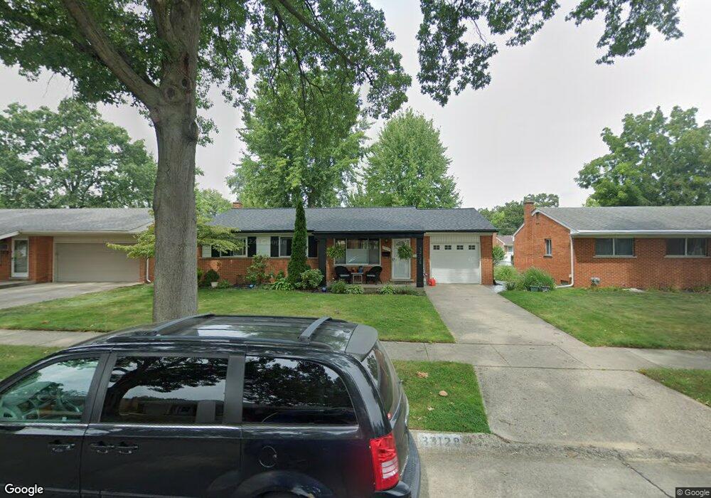
33128 Allen St Livonia, MI 48154
Estimated Value: $271,239 - $317,000
2
Beds
3
Baths
1,083
Sq Ft
$274/Sq Ft
Est. Value
About This Home
This home is located at 33128 Allen St, Livonia, MI 48154 and is currently estimated at $297,060, approximately $274 per square foot. 33128 Allen St is a home located in Wayne County with nearby schools including Kennedy Elementary School, Johnson Upper Elementary School, and Frost Middle School.
Ownership History
Date
Name
Owned For
Owner Type
Purchase Details
Closed on
Sep 6, 2013
Sold by
Rubenson Greg E and Rubenson Kelly A
Bought by
Rubenson Greg E and Rubenson Kelly A
Current Estimated Value
Home Financials for this Owner
Home Financials are based on the most recent Mortgage that was taken out on this home.
Original Mortgage
$118,000
Outstanding Balance
$88,021
Interest Rate
4.39%
Mortgage Type
New Conventional
Estimated Equity
$209,039
Purchase Details
Closed on
Jun 12, 1996
Sold by
Rubenson Greg and Rubenson Kelly
Bought by
Sprow Christopher and Sprow Lisa
Create a Home Valuation Report for This Property
The Home Valuation Report is an in-depth analysis detailing your home's value as well as a comparison with similar homes in the area
Home Values in the Area
Average Home Value in this Area
Purchase History
| Date | Buyer | Sale Price | Title Company |
|---|---|---|---|
| Rubenson Greg E | -- | 1St State Title Llc | |
| Sprow Christopher | $120,000 | -- |
Source: Public Records
Mortgage History
| Date | Status | Borrower | Loan Amount |
|---|---|---|---|
| Open | Rubenson Greg E | $118,000 |
Source: Public Records
Tax History Compared to Growth
Tax History
| Year | Tax Paid | Tax Assessment Tax Assessment Total Assessment is a certain percentage of the fair market value that is determined by local assessors to be the total taxable value of land and additions on the property. | Land | Improvement |
|---|---|---|---|---|
| 2025 | $1,760 | $138,500 | $0 | $0 |
| 2024 | $1,760 | $123,000 | $0 | $0 |
| 2023 | $1,679 | $109,800 | $0 | $0 |
| 2022 | $2,949 | $101,500 | $0 | $0 |
| 2021 | $2,864 | $97,200 | $0 | $0 |
| 2019 | $2,748 | $84,300 | $0 | $0 |
| 2018 | $1,420 | $79,900 | $0 | $0 |
| 2017 | $2,513 | $76,100 | $0 | $0 |
| 2016 | $2,642 | $76,100 | $0 | $0 |
| 2015 | $6,296 | $69,100 | $0 | $0 |
| 2012 | -- | $60,890 | $16,430 | $44,460 |
Source: Public Records
Map
Nearby Homes
- 33040 Allen St
- 33025 Martin St
- 32925 Martin St
- 32950 Perth St
- 15075 Hubbard St Unit 5
- 14214 Cranston St
- 32651 5 Mile Rd Unit 15
- 32136 Lyndon St
- 14677 Auburndale St
- 15040 Berwick St
- 14563 Melrose St
- 14327 Arden St
- 15873 Shadyside Dr
- 14109 Arden St
- 14836 Gary Ln
- 31126 Grennada St
- 31221 Lyndon St
- 15600 Auburndale St
- 14164 Bainbridge St
- 14292 Hubbell St
- 33114 Allen St
- 33142 Allen St
- 33131 Lyndon St
- 33086 Allen St
- 33147 Lyndon St
- 33158 Allen St
- 33115 Lyndon St
- 33161 Lyndon St
- 33131 Allen St
- 33117 Allen St
- 33074 Allen St
- 33087 Lyndon St
- 33149 Allen St
- 33089 Allen St
- 33163 Allen St
- 33058 Allen St
- 33075 Allen St
- 33053 Lyndon St
- 33209 Lyndon St
- 14423 Westmore St