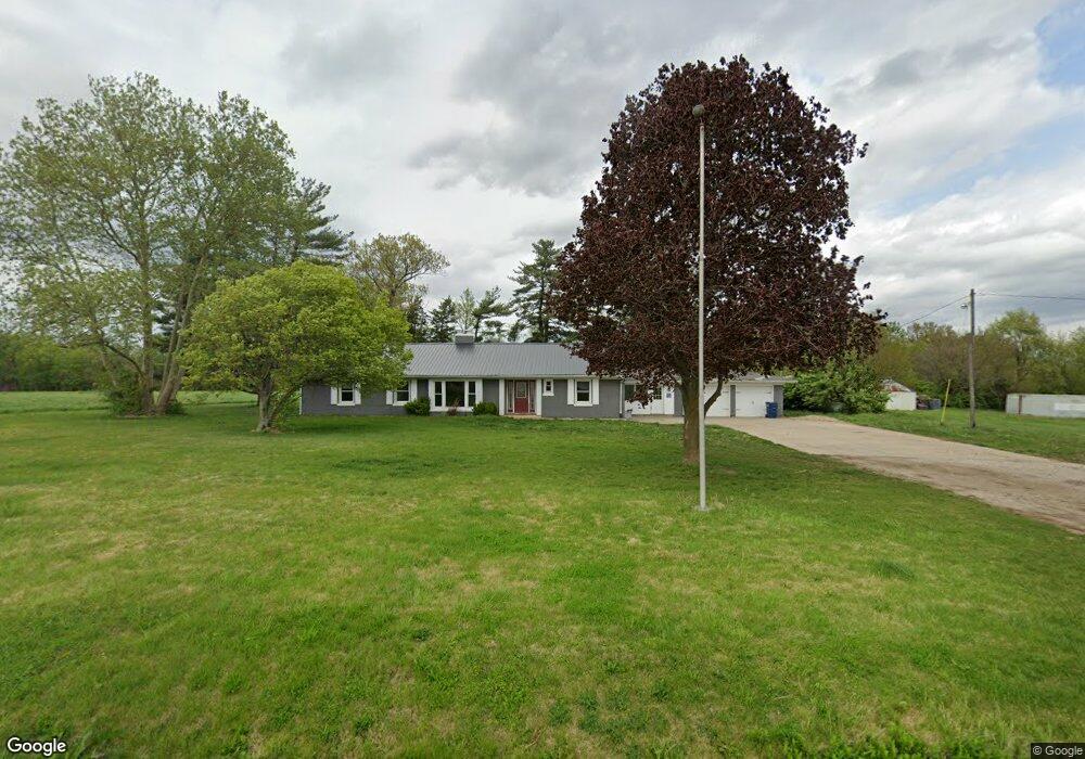
3313 Burnstine Rd Auburn, IL 62615
Estimated Value: $232,000 - $336,492
--
Bed
--
Bath
--
Sq Ft
6
Acres
About This Home
This home is located at 3313 Burnstine Rd, Auburn, IL 62615 and is currently estimated at $279,123. 3313 Burnstine Rd is a home with nearby schools including Auburn Elementary School, Auburn Middle School, and Auburn Junior High School.
Ownership History
Date
Name
Owned For
Owner Type
Purchase Details
Closed on
Nov 2, 2023
Sold by
Moriconi Salvatore
Bought by
Connor Properties Llc
Current Estimated Value
Purchase Details
Closed on
Oct 27, 2023
Sold by
Moriconi Salvatore
Bought by
Connor Properties Llc
Purchase Details
Closed on
Dec 15, 2011
Purchase Details
Closed on
Jul 27, 1997
Purchase Details
Closed on
Nov 1, 1996
Create a Home Valuation Report for This Property
The Home Valuation Report is an in-depth analysis detailing your home's value as well as a comparison with similar homes in the area
Home Values in the Area
Average Home Value in this Area
Purchase History
| Date | Buyer | Sale Price | Title Company |
|---|---|---|---|
| Connor Properties Llc | -- | None Listed On Document | |
| Connor Properties Llc | -- | None Listed On Document | |
| -- | $90,000 | -- | |
| -- | -- | -- | |
| -- | -- | -- |
Source: Public Records
Tax History Compared to Growth
Tax History
| Year | Tax Paid | Tax Assessment Tax Assessment Total Assessment is a certain percentage of the fair market value that is determined by local assessors to be the total taxable value of land and additions on the property. | Land | Improvement |
|---|---|---|---|---|
| 2024 | $4,805 | $85,901 | $33,515 | $52,386 |
| 2023 | $4,648 | $78,556 | $30,649 | $47,907 |
| 2022 | $4,350 | $74,376 | $29,018 | $45,358 |
| 2021 | $4,239 | $71,426 | $27,867 | $43,559 |
| 2020 | $4,239 | $71,177 | $27,770 | $43,407 |
| 2019 | $4,152 | $69,414 | $27,082 | $42,332 |
| 2018 | $4,081 | $67,979 | $26,522 | $41,457 |
| 2017 | $3,987 | $65,459 | $25,539 | $39,920 |
| 2016 | $3,937 | $65,049 | $25,379 | $39,670 |
| 2015 | $3,924 | $64,290 | $25,083 | $39,207 |
| 2014 | $3,923 | $65,289 | $25,473 | $39,816 |
| 2013 | $3,559 | $63,142 | $24,635 | $38,507 |
Source: Public Records
Map
Nearby Homes
- 3926 Circle Dr Unit 1
- 108 N Rose Dr
- 158 E Monroe St
- 1214 W Jefferson St Unit 1
- 10553 S Main St Unit 1
- 233 W South St Unit 1
- 1 Henrietta
- 108 Kodiak Dr
- 512 High School St Unit 1
- 448 Wintergreen Dr
- 0 State Route 4
- 26 Circle
- 404 Sundown Ln
- 34 Buckingham Rd Unit 1
- 530 S Grand Ave
- 2214 Hopwood Dr
- 337 Keystone Dr
- 309 Dewberry Trail
- 327 Aspen Dr
- 315 Aspen Dr
- 3259 Burnstine Rd Unit 1
- 3125 Burnstine Rd Unit 1
- 3197 Burnstine Rd
- 0 Burnstine Rd
- 13530 Bab Rd Unit 1
- 13560 Bab Rd Unit 1
- 13500 Bab Rd Unit 1
- 13525 Bab Rd
- 13487 Bab Rd Unit 1
- 13491 Bab Rd Unit 1
- 00 Bab Rd
- 13565 Bab Rd
- 13318 Bab Rd
- 13320 Bab Rd
- 13310 Bab Rd
- 13331 Bab Rd Unit 1
- 13615 Bab Rd
- 13261 Bab Rd Unit 1
- 2829 Burnstine Rd
- 13160 Bab Rd