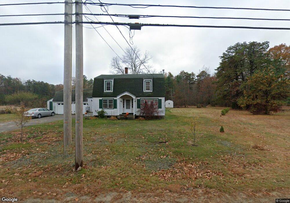
332 Alfred Rd Kennebunk, ME 04043
Estimated Value: $591,053 - $661,000
3
Beds
2
Baths
1,928
Sq Ft
$322/Sq Ft
Est. Value
About This Home
This home is located at 332 Alfred Rd, Kennebunk, ME 04043 and is currently estimated at $621,351, approximately $322 per square foot. 332 Alfred Rd is a home located in York County with nearby schools including Kennebunk High School and The New School.
Ownership History
Date
Name
Owned For
Owner Type
Purchase Details
Closed on
Aug 18, 2006
Sold by
Boucher Dawne A
Bought by
Mcenaney Maureen N and Mcenaney Michael T
Current Estimated Value
Home Financials for this Owner
Home Financials are based on the most recent Mortgage that was taken out on this home.
Original Mortgage
$185,200
Outstanding Balance
$111,914
Interest Rate
6.88%
Mortgage Type
Purchase Money Mortgage
Estimated Equity
$509,437
Create a Home Valuation Report for This Property
The Home Valuation Report is an in-depth analysis detailing your home's value as well as a comparison with similar homes in the area
Home Values in the Area
Average Home Value in this Area
Purchase History
| Date | Buyer | Sale Price | Title Company |
|---|---|---|---|
| Mcenaney Maureen N | -- | -- |
Source: Public Records
Mortgage History
| Date | Status | Borrower | Loan Amount |
|---|---|---|---|
| Open | Mcenaney Maureen N | $185,200 | |
| Closed | Mcenaney Maureen N | $21,300 |
Source: Public Records
Tax History Compared to Growth
Tax History
| Year | Tax Paid | Tax Assessment Tax Assessment Total Assessment is a certain percentage of the fair market value that is determined by local assessors to be the total taxable value of land and additions on the property. | Land | Improvement |
|---|---|---|---|---|
| 2024 | $5,426 | $320,100 | $91,400 | $228,700 |
| 2023 | $5,138 | $320,100 | $91,400 | $228,700 |
| 2022 | $4,673 | $320,100 | $91,400 | $228,700 |
| 2021 | $4,561 | $320,100 | $91,400 | $228,700 |
| 2020 | $4,529 | $320,100 | $91,400 | $228,700 |
| 2019 | $4,401 | $320,100 | $91,400 | $228,700 |
| 2018 | $4,606 | $240,100 | $68,500 | $171,600 |
| 2017 | $3,618 | $218,600 | $68,500 | $150,100 |
| 2016 | $3,476 | $218,600 | $68,500 | $150,100 |
| 2015 | $3,345 | $218,600 | $68,500 | $150,100 |
| 2014 | $3,257 | $218,600 | $68,500 | $150,100 |
Source: Public Records
Map
Nearby Homes
- 18 Cascade Cir Unit 12
- 20 Cascade Cir Unit 11
- 7 Meander Ln Unit 3
- 284 Alfred Rd Unit Lot F13
- 13 Tranquility Dr Unit 20
- 12 Tranquility Dr Unit 17
- 276 Alfred Rd
- 274 Alfred Rd
- 24-4,25-10 Chapman Ln
- 9 Hammond Rd
- 9 Patterson Dr
- 265 Webber Hill Rd
- 1 Robinson Way Unit B 91
- 1 Robinson Way Unit B75
- 30 Twine Mill Rd
- 141 Thompson Rd
- 0 Potvin Rd
- 23 Cascade Cir Unit 22
- 4 Furbish Ln
- lot #3 Salvato Ln
- 40 Cascade Cir Unit 33
- 331 Alfred Rd
- 342 Alfred Rd
- 339 Alfred Rd
- 324 Alfred Rd
- 15 Cascade Cir Unit 18
- 321 Alfred Rd
- 00 Alfred Rd
- 328 Alfred Rd
- 1 Paul John Ave
- 325 Alfred Rd
- 310 Alfred Rd
- 3 Stonington Place
- 311 Alfred Rd
- 356 Alfred Rd
- 31 Stonington Place
- 8 Stonington Place
- 300 Alfred Rd
- 12 Coyne-McKay Ln
- 12 Coyne McKay Ln