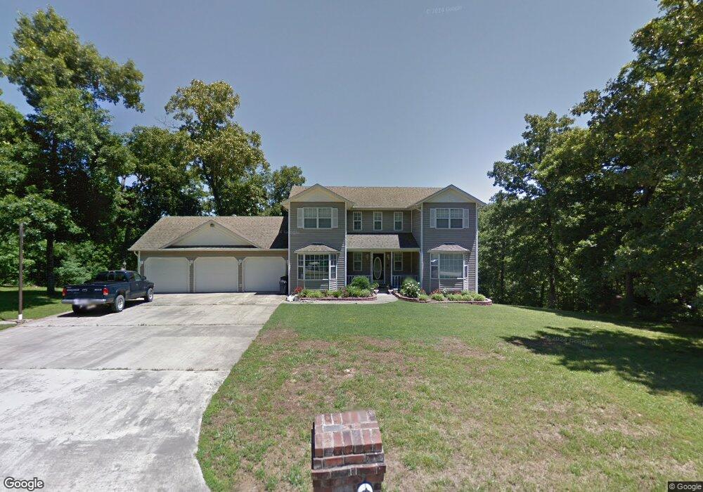
332 County Road 475 Poplar Bluff, MO 63901
Estimated Value: $212,000 - $446,000
5
Beds
--
Bath
2,300
Sq Ft
$143/Sq Ft
Est. Value
About This Home
This home is located at 332 County Road 475, Poplar Bluff, MO 63901 and is currently estimated at $328,314, approximately $142 per square foot. 332 County Road 475 is a home located in Butler County with nearby schools including Poplar Bluff Fifth & Sixth Grade Center, Oak Grove Elementary School, and Poplar Bluff Junior High School.
Ownership History
Date
Name
Owned For
Owner Type
Purchase Details
Closed on
Apr 21, 2022
Sold by
Wayne Robards Herschel and Wayne Ann Dana
Bought by
Lack David R
Current Estimated Value
Purchase Details
Closed on
Jan 23, 2008
Sold by
U S Bank N A
Bought by
Collins Grant M and Swiney Shonna D
Purchase Details
Closed on
Nov 19, 2007
Sold by
Brown Michael A and Brown Sharon L
Bought by
Us Bank Na
Purchase Details
Closed on
Oct 28, 2005
Sold by
Cendant Mobility Financial Corp
Bought by
Brown Michael A and Brown Sharon L
Home Financials for this Owner
Home Financials are based on the most recent Mortgage that was taken out on this home.
Original Mortgage
$31,875
Interest Rate
5.75%
Mortgage Type
Stand Alone Second
Create a Home Valuation Report for This Property
The Home Valuation Report is an in-depth analysis detailing your home's value as well as a comparison with similar homes in the area
Purchase History
| Date | Buyer | Sale Price | Title Company |
|---|---|---|---|
| Lack David R | -- | None Listed On Document | |
| Collins Grant M | -- | -- | |
| Us Bank Na | -- | -- | |
| Brown Michael A | -- | -- |
Source: Public Records
Mortgage History
| Date | Status | Borrower | Loan Amount |
|---|---|---|---|
| Previous Owner | Brown Michael A | $31,875 |
Source: Public Records
Tax History
| Year | Tax Paid | Tax Assessment Tax Assessment Total Assessment is a certain percentage of the fair market value that is determined by local assessors to be the total taxable value of land and additions on the property. | Land | Improvement |
|---|---|---|---|---|
| 2024 | $21 | $48,150 | $0 | $0 |
| 2023 | $2,144 | $48,150 | $0 | $0 |
| 2022 | $2,073 | $46,640 | $0 | $0 |
| 2021 | $2,074 | $46,640 | $0 | $0 |
| 2020 | $1,673 | $37,040 | $0 | $0 |
| 2019 | $1,671 | $37,040 | $0 | $0 |
| 2018 | $1,671 | $37,040 | $0 | $0 |
| 2017 | -- | $37,040 | $0 | $0 |
| 2016 | -- | $37,040 | $0 | $0 |
| 2015 | -- | $37,040 | $0 | $0 |
| 2014 | -- | $34,730 | $0 | $0 |
| 2012 | $1,316 | $34,550 | $0 | $0 |
Source: Public Records
Map
Nearby Homes
- 2031 Carter State Highway M
- 145 Fortitude Ave
- 647 County Road 470
- 213 Murfield Dr
- 0 County Road 450
- 233 Ruth Harris Ln
- 231 Ruth Harris Ln
- 238 Ruth Harris Ln
- 534 Highway M
- 303 Grady
- 0 County Road 472
- 265 Berkshire Dr
- 269 Berkshire Dr
- 0 Lot 22 Legacy Estates Unit MAR25007101
- 0 Lot 15 Legacy Estates
- 0 Lot 23 Legacy Estates
- 0 Lot 62 Legacy Estates
- 325 County Road 467
- 246 Berkshire Dr
- Lot 1 W Highland Cir
- 528 County Road 4702
- 430 County Road 475
- 251 County Road 475
- 403 County Road 475
- 437 County Road 475
- 365 County Road 4751
- 297 County Road 4751
- 514 County Road 4702
- 491 County Road 475
- 628 County Road 4702
- 626 County Road 475
- 478 County Road 4702
- 535 County Road 4702
- 598 County Road 475
- 487 County Road 4702
- 487 Cr 4702
- 589 County Road 4702
- 511 County Road 475
- 555 County Road 475
- 195 County Road 4751
Your Personal Tour Guide
Ask me questions while you tour the home.