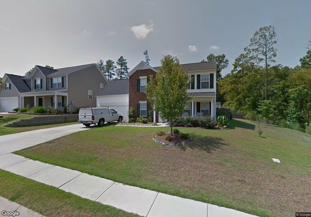
332 Foxport Dr Chapin, SC 29036
Estimated Value: $252,000 - $327,671
4
Beds
3
Baths
2,326
Sq Ft
$132/Sq Ft
Est. Value
About This Home
This home is located at 332 Foxport Dr, Chapin, SC 29036 and is currently estimated at $306,418, approximately $131 per square foot. 332 Foxport Dr is a home located in Richland County with nearby schools including Lake Murray Elementary School, Chapin Intermediate, and Chapin High School.
Ownership History
Date
Name
Owned For
Owner Type
Purchase Details
Closed on
Sep 11, 2024
Sold by
Hoffman Michael F and Hoffman Elise H
Bought by
Hoffman Michael F and Hoffman Elise H
Current Estimated Value
Purchase Details
Closed on
Sep 7, 2007
Sold by
Mungo Homes Inc
Bought by
Hoffman Michael F and Hoffman Elise H
Home Financials for this Owner
Home Financials are based on the most recent Mortgage that was taken out on this home.
Original Mortgage
$185,511
Interest Rate
6.65%
Mortgage Type
Purchase Money Mortgage
Create a Home Valuation Report for This Property
The Home Valuation Report is an in-depth analysis detailing your home's value as well as a comparison with similar homes in the area
Home Values in the Area
Average Home Value in this Area
Purchase History
| Date | Buyer | Sale Price | Title Company |
|---|---|---|---|
| Hoffman Michael F | -- | None Listed On Document | |
| Hoffman Michael F | $186,977 | None Available |
Source: Public Records
Mortgage History
| Date | Status | Borrower | Loan Amount |
|---|---|---|---|
| Previous Owner | Hoffman Michael F | $185,511 |
Source: Public Records
Tax History Compared to Growth
Tax History
| Year | Tax Paid | Tax Assessment Tax Assessment Total Assessment is a certain percentage of the fair market value that is determined by local assessors to be the total taxable value of land and additions on the property. | Land | Improvement |
|---|---|---|---|---|
| 2024 | $1,948 | $215,900 | $0 | $0 |
| 2023 | $1,873 | $7,508 | $0 | $0 |
| 2022 | $1,627 | $187,700 | $26,400 | $161,300 |
| 2021 | $1,637 | $7,510 | $0 | $0 |
| 2020 | $1,704 | $7,480 | $0 | $0 |
| 2019 | $1,684 | $7,480 | $0 | $0 |
| 2018 | $1,488 | $7,450 | $0 | $0 |
| 2017 | $1,450 | $7,450 | $0 | $0 |
| 2016 | $1,444 | $7,450 | $0 | $0 |
| 2015 | $1,451 | $7,450 | $0 | $0 |
| 2014 | $1,447 | $186,300 | $0 | $0 |
| 2013 | -- | $7,450 | $0 | $0 |
Source: Public Records
Map
Nearby Homes
- 44 Rustyred Ct
- 342 Murray Falls Ln
- 142 Almofini Ln
- 740 Ruskin Dr
- 550 Malachite Ln
- 515 Malachite Ln
- 509 Malachite Ln
- 13 Botticelli Ct
- 175 Almofini Ln
- 818 Ruskin Dr
- 1318 Portrait Hill Dr
- 705 Ruskin Dr
- 424 Lombard Way
- 328 Murray Falls Ln
- Lot 4 Lake Breeze
- 7 Elk Run Ct
- 319 Murray Falls Ln
- 13 Elk Run Ct
- 19 Elk Run Ct
- 242 Murray Falls Ln
- 336 Foxport Dr
- 333 Foxport Dr
- 340 Foxport Dr
- 341 Foxport Dr
- 337 Foxport Dr
- 344 Foxport Dr
- 345 Foxport Dr
- 348 Foxport Dr
- 101 Stoney Point Ln
- 351 Foxport Dr
- 321 Foxport Dr
- 320 Foxport Dr
- 352 Foxport Dr
- 533 Foxstone Dr
- 317 Foxport Dr
- 357 Foxport Dr
- 529 Foxstone Dr
- 316 Foxport Dr
- 307 Foxport Dr
- 356 Foxport Dr