Estimated Value: $808,000 - $900,000
6
Beds
4
Baths
3,934
Sq Ft
$216/Sq Ft
Est. Value
About This Home
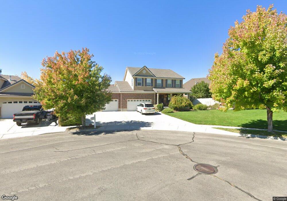
This home is located at 3325 N 700 W, Lehi, UT 84043 and is currently estimated at $848,512, approximately $215 per square foot. 3325 N 700 W is a home located in Utah County with nearby schools including Fox Hollow Elementary School, Skyridge High School, and Ignite Entrepreneurship Academy.
Ownership History
Date
Name
Owned For
Owner Type
Purchase Details
Closed on
Jul 20, 2022
Sold by
Merrill Squire
Bought by
Maxwell Trent and Maxwell Natalie
Current Estimated Value
Home Financials for this Owner
Home Financials are based on the most recent Mortgage that was taken out on this home.
Original Mortgage
$500,000
Outstanding Balance
$476,265
Interest Rate
5.23%
Mortgage Type
New Conventional
Estimated Equity
$372,247
Purchase Details
Closed on
Mar 16, 2005
Sold by
Richmond American Homes Of Utah Inc
Bought by
Squire Merrill and Squire Joanna C
Home Financials for this Owner
Home Financials are based on the most recent Mortgage that was taken out on this home.
Original Mortgage
$159,150
Interest Rate
5.61%
Mortgage Type
Purchase Money Mortgage
Create a Home Valuation Report for This Property
The Home Valuation Report is an in-depth analysis detailing your home's value as well as a comparison with similar homes in the area
Home Values in the Area
Average Home Value in this Area
Purchase History
| Date | Buyer | Sale Price | Title Company |
|---|---|---|---|
| Maxwell Trent | -- | Gt Title Services | |
| Squire Merrill | -- | First American Title Co |
Source: Public Records
Mortgage History
| Date | Status | Borrower | Loan Amount |
|---|---|---|---|
| Open | Maxwell Trent | $500,000 | |
| Previous Owner | Squire Merrill | $159,150 |
Source: Public Records
Tax History Compared to Growth
Tax History
| Year | Tax Paid | Tax Assessment Tax Assessment Total Assessment is a certain percentage of the fair market value that is determined by local assessors to be the total taxable value of land and additions on the property. | Land | Improvement |
|---|---|---|---|---|
| 2025 | $3,489 | $450,780 | $338,100 | $481,500 |
| 2024 | $3,489 | $408,320 | $0 | $0 |
| 2023 | $3,255 | $413,655 | $0 | $0 |
| 2022 | $3,180 | $391,710 | $0 | $0 |
| 2021 | $2,798 | $521,000 | $195,700 | $325,300 |
| 2020 | $2,636 | $485,200 | $181,200 | $304,000 |
| 2019 | $2,430 | $465,100 | $181,200 | $283,900 |
| 2018 | $2,495 | $451,300 | $177,700 | $273,600 |
| 2017 | $2,284 | $219,725 | $0 | $0 |
| 2016 | $2,322 | $207,240 | $0 | $0 |
| 2015 | $2,304 | $195,140 | $0 | $0 |
| 2014 | $2,248 | $189,310 | $0 | $0 |
Source: Public Records
Map
Nearby Homes
- 389 W 3200 N
- 337 W 3200 N
- 3117 N 325 W
- 3773 N 750 W
- 3279 N 150 W
- 3324 N 150 W
- Cleveland Plan at Fox Canyon
- Balsam Plan at Fox Canyon
- Basswood Plan at Fox Canyon
- Harrison Plan at Fox Canyon
- Sycamore Plan at Fox Canyon
- Monroe Plan at Fox Canyon
- Yukon Plan at Fox Canyon
- Ash Plan at Fox Canyon
- Charles Plan at Fox Canyon
- Spruce Pantry Plan at Fox Canyon
- Madison Plan at Fox Canyon
- Chapman Plan at Fox Canyon
- Hancock Plan at Fox Canyon
- Harmony Plan at Fox Canyon
- 3317 N 700 W
- 665 W Hillside Dr
- 633 W Hillside Dr
- 701 W Hillside Dr
- 3289 N 700 W
- 3326 N 700 W
- 714 W 3275 N
- 45 Hillside Dr Unit 45
- 12 Hillside Dr Unit 12
- 3372 N Hillside Dr Unit 5
- 3318 N 700 W
- 727 W Hillside Dr
- 3292 N 700 W
- 362 W Hillside Dr
- 678 Hillside Dr
- 678 W Hillside Dr
- 3265 N 700 W
- 716 W Hillside Dr
- 726 W 3275 N
- 668 W 3275 N