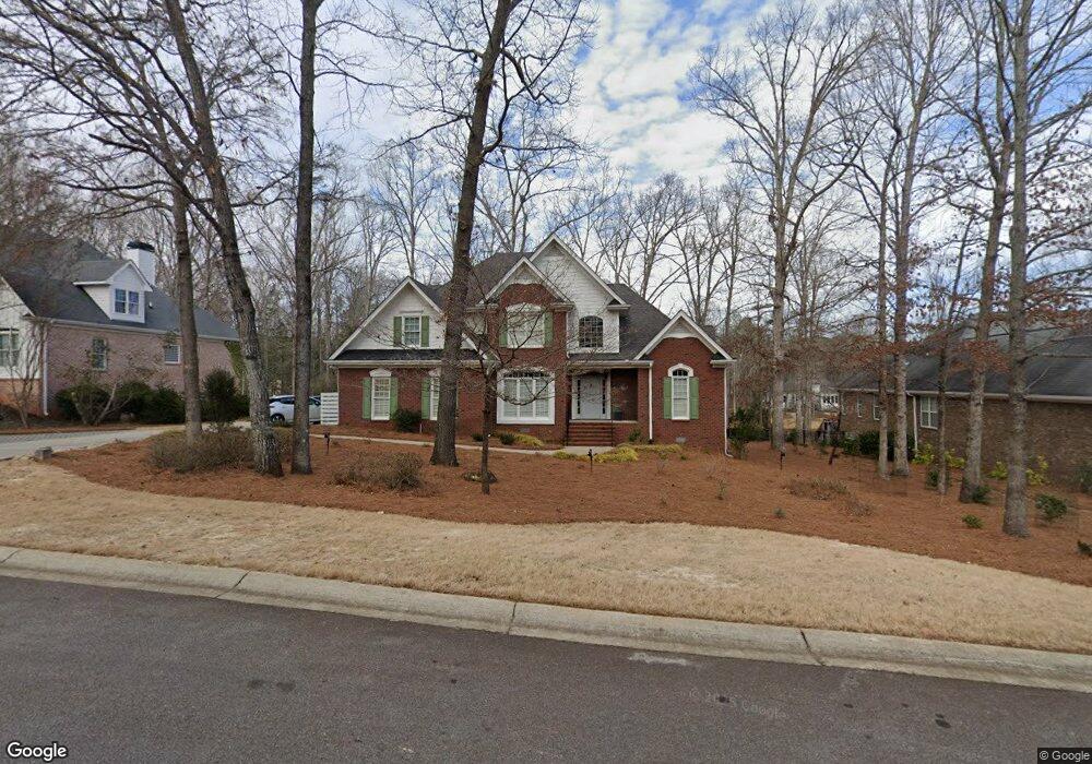
333 Ashbrook Ln Athens, GA 30605
Estimated Value: $523,245 - $606,000
4
Beds
4
Baths
2,678
Sq Ft
$212/Sq Ft
Est. Value
About This Home
This home is located at 333 Ashbrook Ln, Athens, GA 30605 and is currently estimated at $568,561, approximately $212 per square foot. 333 Ashbrook Ln is a home located in Clarke County with nearby schools including Barnett Shoals Elementary School, Hilsman Middle School, and Cedar Shoals High School.
Ownership History
Date
Name
Owned For
Owner Type
Purchase Details
Closed on
Jun 26, 2019
Sold by
Carrier Ronald L
Bought by
Mcmaster Patrick M and Mcmaster Alice R
Current Estimated Value
Home Financials for this Owner
Home Financials are based on the most recent Mortgage that was taken out on this home.
Original Mortgage
$268,000
Outstanding Balance
$234,176
Interest Rate
3.9%
Mortgage Type
New Conventional
Estimated Equity
$334,385
Purchase Details
Closed on
Jul 18, 2006
Sold by
Not Provided
Bought by
Carrier Ronald L and Carrier Roberta H
Home Financials for this Owner
Home Financials are based on the most recent Mortgage that was taken out on this home.
Original Mortgage
$214,000
Interest Rate
6.63%
Mortgage Type
New Conventional
Purchase Details
Closed on
Nov 1, 2004
Sold by
Michael J Ross Construction In
Bought by
Edge Scott
Purchase Details
Closed on
Oct 29, 2003
Sold by
Ashton Place Partnership
Bought by
Michael J Ross Construction Inc
Create a Home Valuation Report for This Property
The Home Valuation Report is an in-depth analysis detailing your home's value as well as a comparison with similar homes in the area
Purchase History
| Date | Buyer | Sale Price | Title Company |
|---|---|---|---|
| Mcmaster Patrick M | $335,000 | -- | |
| Carrier Ronald L | $305,000 | -- | |
| Edge Scott | $299,500 | -- | |
| Michael J Ross Construction Inc | $45,000 | -- |
Source: Public Records
Mortgage History
| Date | Status | Borrower | Loan Amount |
|---|---|---|---|
| Open | Mcmaster Patrick M | $268,000 | |
| Previous Owner | Carrier Ronald L | $214,000 | |
| Previous Owner | Carrier Ronald L | $30,500 |
Source: Public Records
Tax History
| Year | Tax Paid | Tax Assessment Tax Assessment Total Assessment is a certain percentage of the fair market value that is determined by local assessors to be the total taxable value of land and additions on the property. | Land | Improvement |
|---|---|---|---|---|
| 2025 | $6,340 | $225,563 | $23,000 | $202,563 |
| 2024 | $6,340 | $211,726 | $20,700 | $191,026 |
| 2023 | $6,117 | $192,260 | $20,700 | $171,560 |
| 2022 | $5,045 | $168,161 | $20,700 | $147,461 |
| 2021 | $4,725 | $150,215 | $20,700 | $129,515 |
| 2020 | $4,179 | $141,024 | $20,700 | $120,324 |
| 2019 | $3,668 | $130,710 | $20,700 | $110,010 |
| 2018 | $3,636 | $128,439 | $20,700 | $107,739 |
| 2017 | $3,484 | $117,544 | $20,700 | $96,844 |
| 2016 | $3,499 | $118,620 | $20,700 | $97,920 |
| 2015 | $3,514 | $119,696 | $20,700 | $98,996 |
| 2014 | $3,427 | $113,414 | $20,700 | $92,714 |
Source: Public Records
Map
Nearby Homes
- 211 Stonecrest Ct
- 109 Layla Ct
- 0 Barnett Shoals Rd Unit Lot 1
- 352 Greencrest Dr
- 625 Forest Rd
- 135 Mcduffie Dr
- 148 Warren Way
- 220 Ansley Dr
- 399 Mcduffie Dr
- 1305 Cedar Shoals Dr Unit 500
- 1283 Cedar Shoals Dr
- 256 Scandia Cir
- 140 Whitehall Rd
- 440 Wood Ln
- 149 Oak Meadow Dr
- 215 Milford Dr
- 400 Ansley Dr
- 375 Brookstone Dr
- 415 Brookstone Dr
- 360 Ansley Dr
- 329 Ashbrook Ln
- 337 Ashbrook Ln
- 210 Ashbrook Way
- 325 Ashbrook Ln
- 341 Ashbrook Ln
- 340 Ashbrook Ln
- 324 Ashbrook Ln
- 321 Ashbrook Ln
- 345 Ashbrook Ln
- Lot 14 Ashbrook Way
- Lot 32 Ashbrook Way
- Lot 13 Ashbrook Way
- 344 Ashbrook Ln
- 206 Ashbrook Way
- 0 Ashbrook Ln Unit CM402727
- 220 Ashbrook Dr
- 224 Ashbrook Dr
- 205 Ashbrook Way
- 214 Ashbrook Dr
- 317 Ashbrook Ln
Your Personal Tour Guide
Ask me questions while you tour the home.