Estimated Value: $1,220,000 - $2,118,000
3
Beds
2
Baths
4,736
Sq Ft
$353/Sq Ft
Est. Value
About This Home
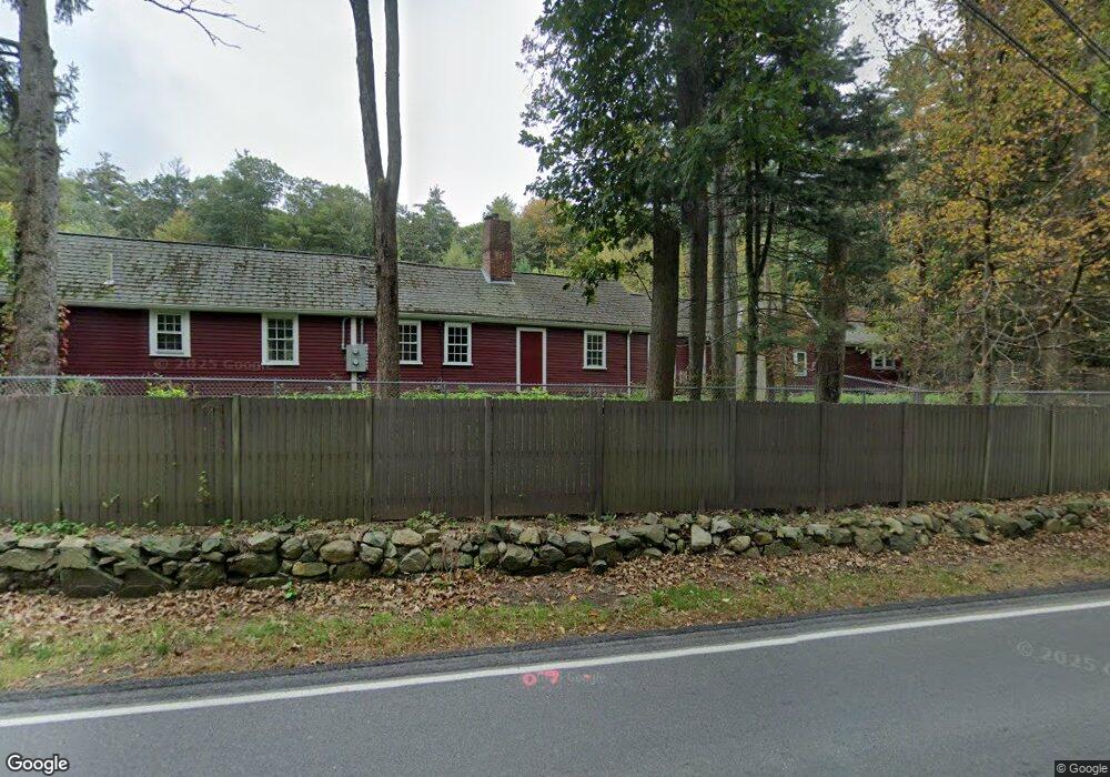
This home is located at 333 Dedham St, Dover, MA 02030 and is currently estimated at $1,673,111, approximately $353 per square foot. 333 Dedham St is a home located in Norfolk County with nearby schools including Chickering Elementary School, Dover-Sherborn Regional Middle School, and Dover-Sherborn Regional High School.
Ownership History
Date
Name
Owned For
Owner Type
Purchase Details
Closed on
Aug 31, 2004
Sold by
Carroll Anne O and Carroll George H
Bought by
Carroll Anne O
Current Estimated Value
Home Financials for this Owner
Home Financials are based on the most recent Mortgage that was taken out on this home.
Original Mortgage
$695,000
Outstanding Balance
$347,532
Interest Rate
6.02%
Mortgage Type
Purchase Money Mortgage
Estimated Equity
$1,325,579
Purchase Details
Closed on
Jun 15, 1999
Sold by
Harvi Charles J and Harvi Dorothy C
Bought by
Carroll George H and Carroll Anne D
Home Financials for this Owner
Home Financials are based on the most recent Mortgage that was taken out on this home.
Original Mortgage
$180,000
Interest Rate
6.9%
Mortgage Type
Purchase Money Mortgage
Create a Home Valuation Report for This Property
The Home Valuation Report is an in-depth analysis detailing your home's value as well as a comparison with similar homes in the area
Home Values in the Area
Average Home Value in this Area
Purchase History
| Date | Buyer | Sale Price | Title Company |
|---|---|---|---|
| Carroll Anne O | $770,000 | -- | |
| Carroll George H | $400,000 | -- |
Source: Public Records
Mortgage History
| Date | Status | Borrower | Loan Amount |
|---|---|---|---|
| Open | Carroll Anne O | $695,000 | |
| Previous Owner | Carroll George H | $180,000 | |
| Previous Owner | Carroll George H | $180,000 |
Source: Public Records
Tax History
| Year | Tax Paid | Tax Assessment Tax Assessment Total Assessment is a certain percentage of the fair market value that is determined by local assessors to be the total taxable value of land and additions on the property. | Land | Improvement |
|---|---|---|---|---|
| 2025 | $17,609 | $1,562,500 | $877,700 | $684,800 |
| 2024 | $16,856 | $1,538,000 | $853,200 | $684,800 |
| 2023 | $15,639 | $1,282,900 | $747,800 | $535,100 |
| 2022 | $15,819 | $1,273,700 | $747,800 | $525,900 |
| 2021 | $16,004 | $1,241,600 | $711,100 | $530,500 |
| 2020 | $15,708 | $1,223,400 | $711,100 | $512,300 |
| 2019 | $15,819 | $1,223,400 | $711,100 | $512,300 |
| 2018 | $14,564 | $1,134,300 | $642,500 | $491,800 |
| 2017 | $15,100 | $1,157,100 | $642,500 | $514,600 |
| 2016 | $15,137 | $1,175,200 | $642,500 | $532,700 |
| 2015 | $14,232 | $1,120,600 | $642,500 | $478,100 |
Source: Public Records
Map
Nearby Homes
- 53 Heather Ln
- 957 South St
- 569 Chestnut St
- 47 Emerson Rd
- 150 Laurel Dr
- 298 Summer St
- 287 High Rock St
- 429 Summer St
- 90 Norfolk St
- 60 Sutton Rd
- 1 Mill St
- 85 Schoolmaster Ln
- 8 Crestview Rd
- 1011 Webster St
- 175 Schoolmaster Ln
- 26 Longmeadow Dr
- 68 Pleasant St Unit 68
- 95 Deerfield Rd
- 233 Warren St
- 34 Stratford Rd
- 333 Dedham St
- 333 Dedham St Unit B
- 333 Dedham St Unit A
- 333 Dedham St Unit 1
- 333 Dedham St Unit 2
- 1 Chestnut St
- 1 Chestnut St Unit 1
- 5 Wilson's Way
- 5 Wilsons Way
- 0 Dedham St
- 3 Wilson's Way
- 3 Wilsons Way
- 10 Wilson's Way
- 9999 Chestnut St
- 100 Wilson Way
- 100 Wilsondale St
- 8 Wilsons Way
- 311 Dedham St
- 770 Chestnut St
- 313 Dedham St
Your Personal Tour Guide
Ask me questions while you tour the home.