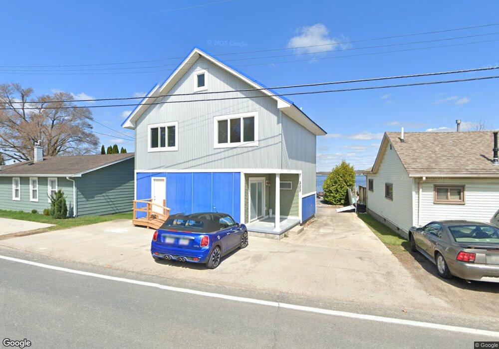
333 E Shore Dr Whitmore Lake, MI 48189
Estimated Value: $518,000 - $653,000
3
Beds
2
Baths
1,982
Sq Ft
$296/Sq Ft
Est. Value
About This Home
This home is located at 333 E Shore Dr, Whitmore Lake, MI 48189 and is currently estimated at $586,510, approximately $295 per square foot. 333 E Shore Dr is a home located in Washtenaw County with nearby schools including Whitmore Lake Elementary School, Whitmore Lake High School, and Livingston Classical Academy.
Ownership History
Date
Name
Owned For
Owner Type
Purchase Details
Closed on
Jun 24, 2011
Sold by
Bartoll Bridget and Bartoll Linda
Bought by
Sulkowski Susan J
Current Estimated Value
Purchase Details
Closed on
May 16, 2003
Sold by
Pospy Genevieve and Bartoll Florence
Bought by
Bartoll Bridget and Bartoll Linda
Home Financials for this Owner
Home Financials are based on the most recent Mortgage that was taken out on this home.
Original Mortgage
$200,000
Interest Rate
5.51%
Create a Home Valuation Report for This Property
The Home Valuation Report is an in-depth analysis detailing your home's value as well as a comparison with similar homes in the area
Home Values in the Area
Average Home Value in this Area
Purchase History
| Date | Buyer | Sale Price | Title Company |
|---|---|---|---|
| Sulkowski Susan J | $229,000 | None Available | |
| Bartoll Bridget | $300,000 | Genesis Title |
Source: Public Records
Mortgage History
| Date | Status | Borrower | Loan Amount |
|---|---|---|---|
| Previous Owner | Bartoll Bridget | $200,000 |
Source: Public Records
Tax History
| Year | Tax Paid | Tax Assessment Tax Assessment Total Assessment is a certain percentage of the fair market value that is determined by local assessors to be the total taxable value of land and additions on the property. | Land | Improvement |
|---|---|---|---|---|
| 2025 | $1,462 | $254,000 | $0 | $0 |
| 2024 | $1,420 | $254,200 | $0 | $0 |
| 2023 | $1,353 | $216,600 | $0 | $0 |
| 2022 | $5,112 | $187,800 | $0 | $0 |
| 2021 | $5,003 | $180,500 | $0 | $0 |
| 2020 | $4,952 | $171,300 | $0 | $0 |
| 2019 | $4,923 | $159,800 | $159,800 | $0 |
| 2018 | $4,829 | $139,500 | $0 | $0 |
| 2017 | $4,611 | $139,000 | $0 | $0 |
| 2016 | $1,163 | $109,435 | $0 | $0 |
| 2015 | -- | $109,108 | $0 | $0 |
| 2014 | -- | $105,700 | $0 | $0 |
| 2013 | -- | $105,700 | $0 | $0 |
Source: Public Records
Map
Nearby Homes
- 66 E Shore Dr
- 39 Pine Dr
- 9509 Main St
- 9638 Main St
- 00 Jennings Rd
- 000 Jennings Rd
- 0000 Jennings Rd
- 11731 Valerie Ln
- 11346 E Shore Dr
- 9416 Wildwood Lake Dr
- 9105 Timbercrest Ln
- 9417 Sandlewood Dr
- 10593 9 Mile Rd
- 10303 9 Mile Rd
- 0 Vl Winters Ln
- 573 Turquoise Dr
- 0 Jennings Rd Unit 26006322
- 629 Turquoise Dr
- 11433 Marshall Rd
- 0 Six Mile Unit 20251006647
- 329 E Shore Dr
- 345 E Shore Dr
- 337 E Shore Dr
- 336 E Shore Dr
- 324 E Shore Dr
- 355 E Shore Dr
- 311 E Shore Dr
- 346 E Shore Dr
- 316 E Shore Dr
- 307 E Shore Dr
- 365 E Shore Dr
- 364 E Shore Dr
- 301 E Shore Dr
- 297 E Shore Dr
- 300 E Shore Dr
- 341 Lillian Ct Unit Bldg-Unit
- 341 Lillian Ct
- 321 Lillian Ct
- 351 Lillian Ct
- 9210 Posey Dr
Your Personal Tour Guide
Ask me questions while you tour the home.