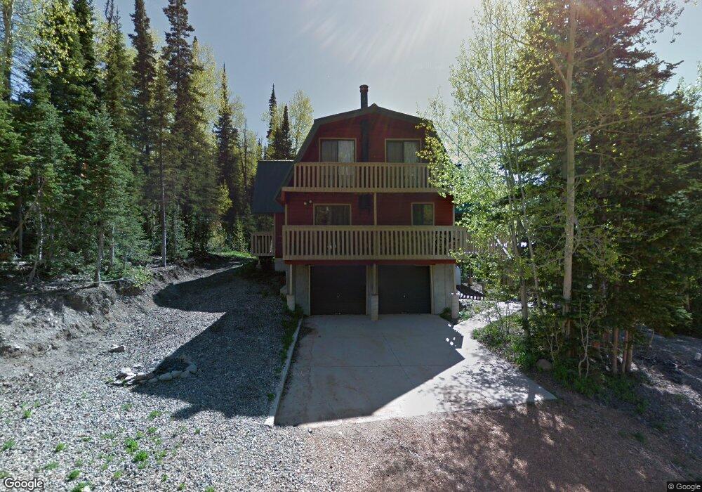
333 Fir St Brian Head, UT 84719
Estimated Value: $724,568 - $746,000
5
Beds
2
Baths
2,832
Sq Ft
$260/Sq Ft
Est. Value
About This Home
This home is located at 333 Fir St, Brian Head, UT 84719 and is currently estimated at $735,284, approximately $259 per square foot. 333 Fir St is a home located in Iron County with nearby schools including Parowan School, Parowan High School, and Cedar City High School.
Ownership History
Date
Name
Owned For
Owner Type
Purchase Details
Closed on
Mar 18, 2022
Sold by
Gray Brian C and Gray Sheila
Bought by
Gray Brian C and Gray Sheila
Current Estimated Value
Home Financials for this Owner
Home Financials are based on the most recent Mortgage that was taken out on this home.
Original Mortgage
$452,900
Outstanding Balance
$366,792
Interest Rate
3.39%
Mortgage Type
New Conventional
Estimated Equity
$368,492
Purchase Details
Closed on
Aug 21, 2010
Sold by
Citibank Na
Bought by
Gray Brian and Gray Sheila
Home Financials for this Owner
Home Financials are based on the most recent Mortgage that was taken out on this home.
Original Mortgage
$140,000
Interest Rate
4.48%
Mortgage Type
New Conventional
Purchase Details
Closed on
Mar 22, 2010
Sold by
Smith Jeffrey B and Smith Kathryn S
Bought by
Us Bank Na
Purchase Details
Closed on
Oct 11, 2005
Sold by
Murray Wendol M and Murray Carol
Bought by
Smith Jeffrey B and Smith Kathryn S
Home Financials for this Owner
Home Financials are based on the most recent Mortgage that was taken out on this home.
Original Mortgage
$117,150
Interest Rate
5.24%
Mortgage Type
Stand Alone Second
Create a Home Valuation Report for This Property
The Home Valuation Report is an in-depth analysis detailing your home's value as well as a comparison with similar homes in the area
Home Values in the Area
Average Home Value in this Area
Purchase History
We collect this data history from publicly available records. To have your information removed, we recommend requesting removal directly through your county’s website.
| Date | Buyer | Sale Price | Title Company |
|---|---|---|---|
| Gray Brian C | -- | New Title Company Name | |
| Gray Brian C | -- | New Title Company Name | |
| Gray Brian | -- | None Available | |
| Us Bank Na | -- | -- | |
| Smith Jeffrey B | -- | -- |
Source: Public Records
Mortgage History
We collect this data history from publicly available records. To have your information removed, we recommend requesting removal directly through your county’s website.
| Date | Status | Borrower | Loan Amount |
|---|---|---|---|
| Open | Gray Brian C | $452,900 | |
| Closed | Gray Brian C | $452,900 | |
| Previous Owner | Gray Brian | $140,000 | |
| Previous Owner | Smith Jeffrey B | $117,150 | |
| Previous Owner | Smith Jeffrey B | $273,350 |
Source: Public Records
Tax History
| Year | Tax Paid | Tax Assessment Tax Assessment Total Assessment is a certain percentage of the fair market value that is determined by local assessors to be the total taxable value of land and additions on the property. | Land | Improvement |
|---|---|---|---|---|
| 2025 | $5,284 | $670,075 | $103,500 | $566,575 |
| 2023 | $4,250 | $576,340 | $103,500 | $472,840 |
| 2022 | $5,586 | $562,840 | $90,000 | $472,840 |
| 2021 | $3,724 | $375,245 | $25,000 | $350,245 |
| 2020 | $3,573 | $328,270 | $25,000 | $303,270 |
| 2019 | $3,496 | $297,010 | $25,000 | $272,010 |
| 2018 | $3,422 | $281,615 | $25,000 | $256,615 |
| 2017 | $3,440 | $281,615 | $25,000 | $256,615 |
| 2016 | $3,361 | $258,285 | $25,000 | $233,285 |
| 2015 | $3,264 | $233,795 | $0 | $0 |
| 2014 | $2,955 | $192,140 | $0 | $0 |
Source: Public Records
Map
Nearby Homes
- 237 Circle Dr
- 590 W Kokopelli Loop
- 699 W Hunter Ridge Dr
- 539 N Half Circle Dr
- 181 Gurr Well Rd
- 0 W Kokopelli Loop Unit 114908
- 0 W Kokopelli Loop Unit 2808823
- 223 W Hunter Ridge Dr Unit b303
- 223 W Hunter Ridge Dr Unit 3306
- 223 W Hunter Ridge Dr Unit b123
- 223 W Hunter Ridge Dr Unit 2303
- 223 W Hunter Ridge Dr Unit 121
- 223 W Hunter Ridge Dr Unit e208
- 223 W Hunter Ridge Dr Unit 2314
- 223 W Hunter Ridge Dr Unit 1300
- 223 W Hunter Ridge Dr Unit 1300, 1310, 2314,
- 223 Hunter Ridge Dr Unit E121
- 0 W Hunter Ridge Dr
- 199 W Hunter Ridge Dr
- 646 W Ski View Dr
- 353 Fir St
- 336 Fir St Unit 3
- 358 Fir St Unit Lot 5 U-A
- 287 Fir St
- 342 Fir St Unit A
- 358 Fir St Unit A
- 287 Fir St Unit A
- 342 Fir St Unit 1
- 342 Fir St
- 309 Fir St Unit MntAir Evergreen U-A
- 309 Fir St
- 320 Fir St Unit Mountair Evergr u-A
- 320 Fir St
- 390 W Spruce St Unit A
- 390 W Spruce St
- 356 Spruce St
- 367 Fir St
- 643 Aspen Dr
- 643 Aspen Dr Unit Mountairevergreen bl
- 301 Fir St
Your Personal Tour Guide
Ask me questions while you tour the home.