Estimated Value: $894,817 - $946,000
4
Beds
4
Baths
2,229
Sq Ft
$417/Sq Ft
Est. Value
About This Home
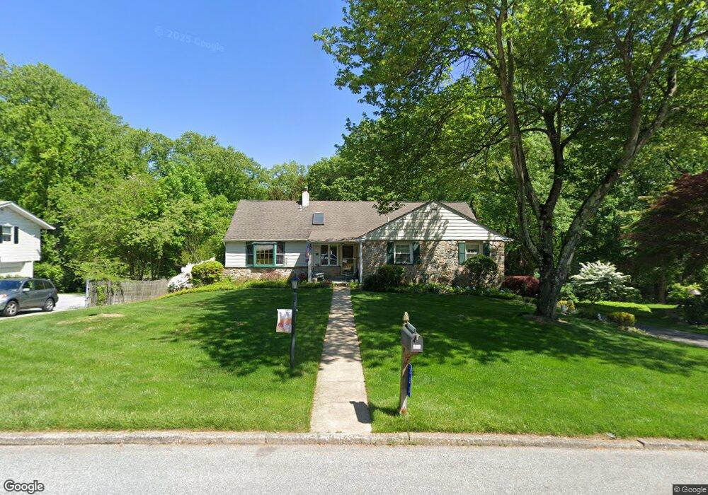
This home is located at 333 Hilltop Rd, Paoli, PA 19301 and is currently estimated at $929,454, approximately $416 per square foot. 333 Hilltop Rd is a home located in Chester County with nearby schools including Hillside Elementary School, Valley Forge Middle School, and Conestoga Senior High School.
Ownership History
Date
Name
Owned For
Owner Type
Purchase Details
Closed on
May 31, 1995
Sold by
Thompson Lyle G and Thompson Barbara M
Bought by
Fad Arthur G and Fad Karen K
Current Estimated Value
Home Financials for this Owner
Home Financials are based on the most recent Mortgage that was taken out on this home.
Original Mortgage
$110,000
Interest Rate
7.7%
Create a Home Valuation Report for This Property
The Home Valuation Report is an in-depth analysis detailing your home's value as well as a comparison with similar homes in the area
Home Values in the Area
Average Home Value in this Area
Purchase History
| Date | Buyer | Sale Price | Title Company |
|---|---|---|---|
| Fad Arthur G | $205,000 | -- |
Source: Public Records
Mortgage History
| Date | Status | Borrower | Loan Amount |
|---|---|---|---|
| Closed | Fad Arthur G | $110,000 |
Source: Public Records
Tax History Compared to Growth
Tax History
| Year | Tax Paid | Tax Assessment Tax Assessment Total Assessment is a certain percentage of the fair market value that is determined by local assessors to be the total taxable value of land and additions on the property. | Land | Improvement |
|---|---|---|---|---|
| 2025 | $7,760 | $220,320 | $91,630 | $128,690 |
| 2024 | $7,760 | $220,320 | $91,630 | $128,690 |
| 2023 | $7,290 | $220,320 | $91,630 | $128,690 |
| 2022 | $7,102 | $220,320 | $91,630 | $128,690 |
| 2021 | $6,814 | $215,500 | $91,630 | $123,870 |
| 2020 | $6,626 | $215,500 | $91,630 | $123,870 |
| 2019 | $6,417 | $215,500 | $91,630 | $123,870 |
| 2018 | $6,290 | $215,500 | $91,630 | $123,870 |
| 2017 | $6,140 | $215,500 | $91,630 | $123,870 |
| 2016 | -- | $215,500 | $91,630 | $123,870 |
| 2015 | -- | $215,500 | $91,630 | $123,870 |
| 2014 | -- | $215,500 | $91,630 | $123,870 |
Source: Public Records
Map
Nearby Homes
- 109 Vincent Rd
- 5 Kent Ln
- 1242 Old Lancaster Rd
- 106 N Valley Rd
- 202 Shoreline Dr
- 521 Foxwood Ln
- 1 Whitworth Ave
- 1441 Berwyn Paoli Rd
- 2102 Quail Ridge Dr
- 1250 Swedesford Rd
- 1304 Weatherstone Dr Unit 1304
- 211 Wooded Way
- 1602 Weatherstone Dr Unit 1602
- 1705 Weatherstone Dr
- 896 Conestoga Rd
- 32 Manchester Ct
- 29 Manor Rd
- 21 Manor Rd
- 104 Lynbrook Rd
- 114 Manor Rd
- 339 Hilltop Rd
- 327 Hilltop Rd
- 326 Hilltop Rd
- 340 Hilltop Rd
- 349 Hilltop Rd
- 317 Hilltop Rd
- 350 Hilltop Rd
- 283 Friendship Dr
- 303 Friendship Dr
- 365 Hilltop Rd
- 309 Friendship Dr
- 291 Friendship Dr
- 373 Hilltop Rd
- 315 Friendship Dr
- 1585 Maple Ave
- 321 Friendship Dr
- 381 Hilltop Rd
- 275 Friendship Dr
- 360 Hilltop Rd
- 366 Hilltop Rd