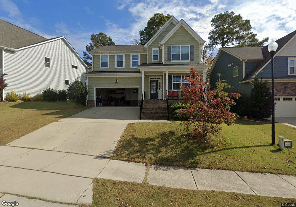
333 Plott Hound Ln Wake Forest, NC 27587
Estimated Value: $486,000 - $547,000
4
Beds
3
Baths
2,847
Sq Ft
$177/Sq Ft
Est. Value
About This Home
This home is located at 333 Plott Hound Ln, Wake Forest, NC 27587 and is currently estimated at $505,220, approximately $177 per square foot. 333 Plott Hound Ln is a home located in Wake County with nearby schools including Sanford Creek Elementary School, Wake Forest-Rolesville Middle School, and Wake Forest High School.
Ownership History
Date
Name
Owned For
Owner Type
Purchase Details
Closed on
Apr 27, 2018
Sold by
Delgado Edna Z Lugo and Monroig Mejias Julio H
Bought by
Tshuma Jimmy and Tshuma Mildred
Current Estimated Value
Home Financials for this Owner
Home Financials are based on the most recent Mortgage that was taken out on this home.
Original Mortgage
$304,385
Outstanding Balance
$266,282
Interest Rate
5.12%
Mortgage Type
FHA
Estimated Equity
$238,938
Purchase Details
Closed on
Apr 16, 2014
Sold by
Lennar Carolinas Llc
Bought by
Delgado Edna Z Lugo and Mejias Julio H Monroig
Home Financials for this Owner
Home Financials are based on the most recent Mortgage that was taken out on this home.
Original Mortgage
$252,628
Interest Rate
4.25%
Mortgage Type
FHA
Create a Home Valuation Report for This Property
The Home Valuation Report is an in-depth analysis detailing your home's value as well as a comparison with similar homes in the area
Home Values in the Area
Average Home Value in this Area
Purchase History
| Date | Buyer | Sale Price | Title Company |
|---|---|---|---|
| Tshuma Jimmy | $310,000 | None Available | |
| Delgado Edna Z Lugo | $258,000 | None Available |
Source: Public Records
Mortgage History
| Date | Status | Borrower | Loan Amount |
|---|---|---|---|
| Open | Tshuma Jimmy | $304,385 | |
| Previous Owner | Delgado Edna Z Lugo | $252,628 |
Source: Public Records
Tax History
| Year | Tax Paid | Tax Assessment Tax Assessment Total Assessment is a certain percentage of the fair market value that is determined by local assessors to be the total taxable value of land and additions on the property. | Land | Improvement |
|---|---|---|---|---|
| 2025 | $4,670 | $483,301 | $80,000 | $403,301 |
| 2024 | $4,653 | $483,301 | $80,000 | $403,301 |
Source: Public Records
Map
Nearby Homes
- 336 Plott Hound Ln
- 2236 Longmont Dr
- 2229 Longmont Dr
- 1824 Longmont Dr
- 1837 Longmont Dr
- 320 Kavanaugh Rd
- 1736 Fern Hollow Trail
- 1620 Wait Ave
- 300 Kavanaugh Rd
- 1716 Main Divide Dr
- 1628 Fern Hollow Trail
- 117 Dry Gully Ct
- 1709 Glazebrook Dr
- 1369 Bessie Ct
- 1365 Bessie Ct
- 1352 Bessie Ct
- 1363 Bessie Ct
- 104 Whey Ct
- 1665 Fern Hollow Trail
- 540 Marthas View Way
- 337 Plott Hound Ln
- 329 Plott Hound Ln
- 325 Plott Hound Ln
- 332 Plott Hound Ln
- 340 Plott Hound Ln
- 328 Plott Hound Ln
- 321 Plott Hound Ln
- 1940 Austin Ridge Pkwy
- 1940 Austin Ridge Pkwy Unit 339
- 1936 Austin Ridge Pkwy Unit 338
- 1932 Austin Ridge Pkwy
- 324 Plott Hound Ln
- 1944 Austin Ridge Pkwy
- 1928 Austin Ridge Pkwy
- 1928 Austin Ridge Pkwy Unit 336
- 1928 Austin Ridge Pkwy
- 1948 Austin Ridge Pkwy Unit 341
- 1924 Austin Ridge Pkwy
- 1952 Austin Ridge Pkwy
- 317 Plott Hound Ln
Your Personal Tour Guide
Ask me questions while you tour the home.