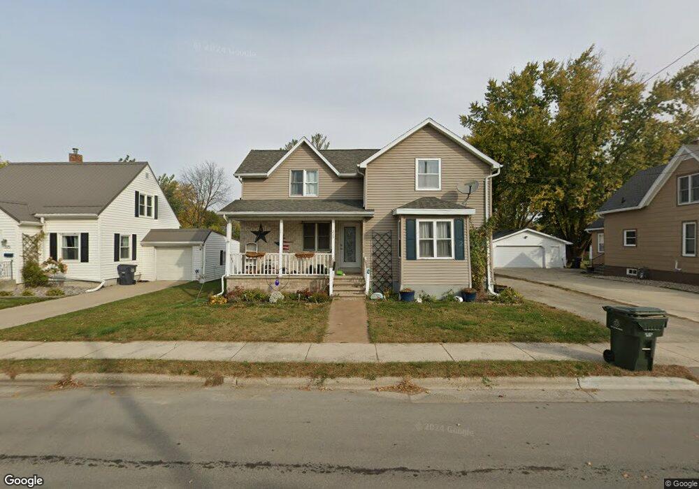
333 Robbins St Seymour, WI 54165
Estimated Value: $245,380 - $267,000
2
Beds
2
Baths
1,337
Sq Ft
$192/Sq Ft
Est. Value
About This Home
This home is located at 333 Robbins St, Seymour, WI 54165 and is currently estimated at $256,095, approximately $191 per square foot. 333 Robbins St is a home located in Outagamie County with nearby schools including Seymour High School and St. John the Baptist School.
Ownership History
Date
Name
Owned For
Owner Type
Purchase Details
Closed on
Nov 18, 2022
Sold by
Zuelke Jeanna Lynne
Bought by
Liesner Roger L
Current Estimated Value
Purchase Details
Closed on
Apr 6, 2011
Sold by
Ilm Investments Llc
Bought by
Liesner Roger L
Purchase Details
Closed on
Dec 1, 2009
Sold by
I L M Investments Llc
Bought by
Liesner Roger L
Purchase Details
Closed on
Nov 16, 2009
Sold by
U S Bank National Association As Trustee
Bought by
Ilm Investment Llc
Purchase Details
Closed on
Apr 23, 2009
Sold by
Bessette Merlin J
Bought by
Us Bank National Association As Trustee
Create a Home Valuation Report for This Property
The Home Valuation Report is an in-depth analysis detailing your home's value as well as a comparison with similar homes in the area
Home Values in the Area
Average Home Value in this Area
Purchase History
| Date | Buyer | Sale Price | Title Company |
|---|---|---|---|
| Liesner Roger L | $5,000 | -- | |
| Liesner Roger L | $89,900 | -- | |
| Liesner Roger L | $89,900 | -- | |
| Ilm Investment Llc | $65,000 | -- | |
| Us Bank National Association As Trustee | $84,200 | -- |
Source: Public Records
Tax History Compared to Growth
Tax History
| Year | Tax Paid | Tax Assessment Tax Assessment Total Assessment is a certain percentage of the fair market value that is determined by local assessors to be the total taxable value of land and additions on the property. | Land | Improvement |
|---|---|---|---|---|
| 2023 | $2,986 | $188,900 | $28,400 | $160,500 |
| 2022 | $2,556 | $114,600 | $16,200 | $98,400 |
| 2021 | $2,344 | $114,600 | $16,200 | $98,400 |
| 2020 | $2,491 | $114,600 | $16,200 | $98,400 |
| 2019 | $2,389 | $114,600 | $16,200 | $98,400 |
| 2018 | $2,477 | $114,600 | $16,200 | $98,400 |
| 2017 | $2,239 | $114,600 | $16,200 | $98,400 |
| 2016 | $2,383 | $120,500 | $16,200 | $104,300 |
| 2015 | $2,413 | $120,500 | $16,200 | $104,300 |
| 2014 | $2,697 | $120,500 | $16,200 | $104,300 |
| 2013 | $2,741 | $120,500 | $16,200 | $104,300 |
Source: Public Records
Map
Nearby Homes
- 226 N Main St
- 364 Lincoln St
- 619 S Main St
- 0 Maple Vista Ct
- 433 Doersch Trail
- 673 W Factory St
- 1212 Northwood Dr
- W3142 High St
- W2441 County Road G
- W3116 Kortney Ln
- W2638 Autumn Blaze Trail
- W1535 Ranch Rd
- 0 Ballard Rd
- W4526 Jeske Rd
- N6525 Laurmar Ln
- W1513 Town Rd
- W2872 Cindy Ct
- W2588 Sievert Rd
- 0 Ashman Rd
- W2028 State Highway 156