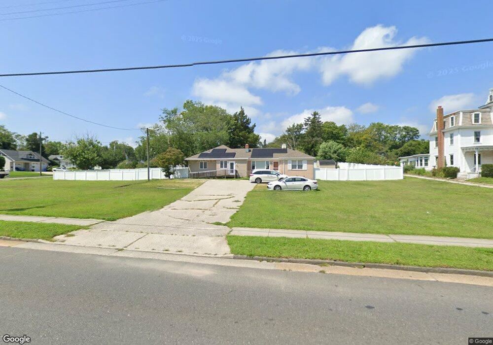
333 S Shore Rd Absecon, NJ 08201
Estimated Value: $349,000 - $425,000
3
Beds
3
Baths
2,096
Sq Ft
$189/Sq Ft
Est. Value
About This Home
This home is located at 333 S Shore Rd, Absecon, NJ 08201 and is currently estimated at $397,187, approximately $189 per square foot. 333 S Shore Rd is a home located in Atlantic County with nearby schools including Emma C. Attales Middle School, Life Point Academy/ Life Point Church, and Holy Spirit High School.
Ownership History
Date
Name
Owned For
Owner Type
Purchase Details
Closed on
Mar 18, 2022
Sold by
Keating John J and Keating Dale M
Bought by
Farzan Mohammad
Current Estimated Value
Home Financials for this Owner
Home Financials are based on the most recent Mortgage that was taken out on this home.
Original Mortgage
$161,500
Interest Rate
4.72%
Mortgage Type
New Conventional
Purchase Details
Closed on
Sep 3, 1980
Bought by
Keating John and Keating Dale M
Create a Home Valuation Report for This Property
The Home Valuation Report is an in-depth analysis detailing your home's value as well as a comparison with similar homes in the area
Home Values in the Area
Average Home Value in this Area
Purchase History
| Date | Buyer | Sale Price | Title Company |
|---|---|---|---|
| Farzan Mohammad | $170,000 | Surety Title | |
| Keating John | $77,000 | -- |
Source: Public Records
Mortgage History
| Date | Status | Borrower | Loan Amount |
|---|---|---|---|
| Previous Owner | Farzan Mohammad | $161,500 |
Source: Public Records
Tax History Compared to Growth
Tax History
| Year | Tax Paid | Tax Assessment Tax Assessment Total Assessment is a certain percentage of the fair market value that is determined by local assessors to be the total taxable value of land and additions on the property. | Land | Improvement |
|---|---|---|---|---|
| 2025 | $5,655 | $169,000 | $111,000 | $58,000 |
| 2024 | $5,655 | $169,000 | $111,000 | $58,000 |
| 2023 | $5,587 | $169,000 | $111,000 | $58,000 |
| 2022 | $5,587 | $169,000 | $111,000 | $58,000 |
| 2021 | $5,570 | $169,000 | $111,000 | $58,000 |
| 2020 | $7,463 | $226,000 | $111,000 | $115,000 |
| 2019 | $7,408 | $226,000 | $111,000 | $115,000 |
| 2018 | $7,440 | $226,000 | $111,000 | $115,000 |
| 2017 | $7,386 | $226,000 | $111,000 | $115,000 |
| 2016 | $7,178 | $226,000 | $111,000 | $115,000 |
| 2015 | $7,085 | $226,000 | $111,000 | $115,000 |
| 2014 | $6,988 | $226,000 | $111,000 | $115,000 |
Source: Public Records
Map
Nearby Homes
- 19 W Illinois Ave
- 15 W Bolton Ave
- 125 Meadowview Ave
- 40 N Shore Rd
- 1508 7th Ave
- 111 Woods Rd
- 107 W Church St
- 1 Mechanic St Unit 108
- 194 N Shore Rd
- 120 Pitney Rd
- 720 S New Rd Unit 2M
- 4 Oyster Bay Rd Unit 4K
- 10 Oyster Bay Rd Unit H
- 202 Burning Tree Blvd
- 2 Oyster Bay Rd Apt D Rd Unit 2D
- 399 Pitney Rd
- 28 Magnolia Place
- 19 Laurel Dr
- 00 California Ave
- 1214 Peterson Way