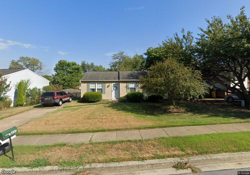
333 Ternwing Dr Arnold, MD 21012
Estimated Value: $345,482 - $472,000
Studio
1
Bath
1,009
Sq Ft
$425/Sq Ft
Est. Value
About This Home
This home is located at 333 Ternwing Dr, Arnold, MD 21012 and is currently estimated at $428,371, approximately $424 per square foot. 333 Ternwing Dr is a home located in Anne Arundel County with nearby schools including Broadneck Elementary School, Magothy River Middle School, and Broadneck High School.
Ownership History
Date
Name
Owned For
Owner Type
Purchase Details
Closed on
Oct 17, 2013
Sold by
Lindsay Virginia I and Lindsay Virginia
Bought by
Lindsay Virginia
Current Estimated Value
Purchase Details
Closed on
Jun 22, 1979
Bought by
Lindsay Felix H and Lindsay Et Al Helen H
Home Financials for this Owner
Home Financials are based on the most recent Mortgage that was taken out on this home.
Original Mortgage
$45,000
Interest Rate
11.1%
Create a Home Valuation Report for This Property
The Home Valuation Report is an in-depth analysis detailing your home's value as well as a comparison with similar homes in the area
Home Values in the Area
Average Home Value in this Area
Purchase History
| Date | Buyer | Sale Price | Title Company |
|---|---|---|---|
| Lindsay Virginia | -- | None Available | |
| Lindsay Felix H | $58,100 | -- |
Source: Public Records
Mortgage History
| Date | Status | Borrower | Loan Amount |
|---|---|---|---|
| Closed | Lindsay Felix H | $45,000 |
Source: Public Records
Tax History
| Year | Tax Paid | Tax Assessment Tax Assessment Total Assessment is a certain percentage of the fair market value that is determined by local assessors to be the total taxable value of land and additions on the property. | Land | Improvement |
|---|---|---|---|---|
| 2025 | $2,473 | $328,133 | -- | -- |
| 2024 | $2,473 | $307,300 | $231,200 | $76,100 |
| 2023 | $2,404 | $304,733 | $0 | $0 |
| 2022 | $2,252 | $302,167 | $0 | $0 |
| 2020 | $2,134 | $285,633 | $0 | $0 |
| 2019 | $2,092 | $271,667 | $0 | $0 |
| 2018 | $2,613 | $257,700 | $173,400 | $84,300 |
| 2017 | $1,971 | $251,567 | $0 | $0 |
| 2016 | -- | $245,433 | $0 | $0 |
| 2015 | -- | $239,300 | $0 | $0 |
| 2014 | -- | $222,467 | $0 | $0 |
Source: Public Records
Map
Nearby Homes
- 930 Whitstable Blvd
- 308 Clifton Ave
- 303 Ternwing Dr
- 319 Alameda Pkwy
- 1078 Brightleaf Ct
- 1233 Birchcrest Ct
- 342 Buena Vista Ave
- 434 College Pkwy
- 312 Rosslare Dr
- 554 Melissa Ct
- 805 Barrett Ave
- 404 Alameda Pkwy
- 394 Kings College Dr
- 413 Ridgeview Ct
- 856 Imperial Rd
- 508 Bay Hills Dr
- 857 Birchwood Ct
- 406 Elmwood Ct
- 854 Imperial Rd
- 852 Birchwood Ct
- 331 Ternwing Dr
- 335 Ternwing Dr
- 337 Ternwing Dr
- 329 Ternwing Dr
- 341 Ternwing Dr
- 334 Ternwing Dr
- 332 Ternwing Dr
- 327 Ternwing Dr
- 336 Ternwing Dr
- 338 Ternwing Dr
- 339 Ternwing Dr
- 330 Ternwing Dr
- 340 Ternwing Dr
- 343 Ternwing Dr
- 328 Ternwing Dr
- 325 Ternwing Dr
- 342 Ternwing Dr
- 351 Ternwing Ct
- 326 Ternwing Dr
- 347 Ternwing Ct
Your Personal Tour Guide
Ask me questions while you tour the home.