
Seller's Agent in 2013
Jennifer Santosuosso
Mendon Local Realty
(508) 369-7218
1 in this area
11 Total Sales
Estimated Value: $626,212 - $729,000
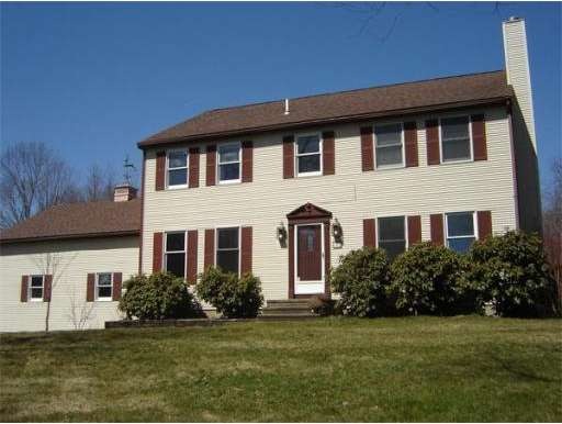
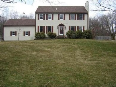
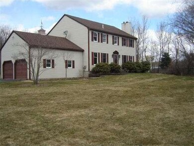
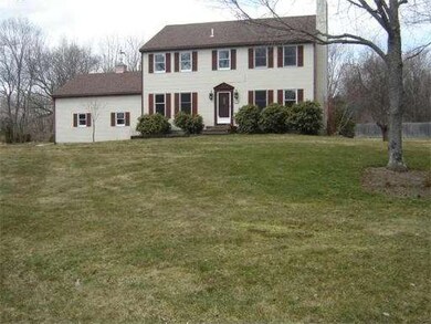
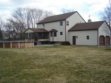
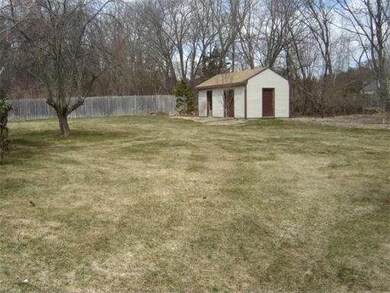
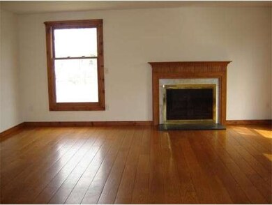
MUST SEE! SPACIOUS 4 BDRM COLONIAL LOCATED ON 1+ ACRE CORNER LOT IN NEIGHBORHOOD SETTING. LG FOYER LEADS TO SUNNY LIVING RM W/FIREPLACE & WIDE PLANK OAK FLOORS. LOVELY KITCHEN W/BKFST BAY OVERLOOKS TREMENDOUS LEVEL BKYD W/CUSTOM PATIO & FIRE PIT. INCREDIBLE SUN ROOM CONNECTS TO DECK & ABOVE GROUND POOL. GREAT FOR ENTERTAINING! MSTR BDRM W/HIS & HER CLOSETS. 600 +/- SQ FT PARTIAL FIN BSMT. OVERSIZED 2 CAR GARAGE. UPDATES INC.: ROOF, CARPETING, & MORE. MINUTES TO MASS PIKE & RTES. 146, 16, & 122.
Last Buyer's Agent
Robert Anderson
Central Mass Real Estate License #454502207
Home Type
Single Family
Year Built
1986
Lot Details
1.16 Acres
| Date | Buyer | Sale Price | Title Company |
|---|---|---|---|
| Quinn Michael F | $315,000 | -- | |
| Quinn Michael F | $315,000 | -- | |
| Miner Deirdre | $182,000 | -- |
| Date | Status | Borrower | Loan Amount |
|---|---|---|---|
| Open | Quinn Michael F | $299,250 | |
| Closed | Quinn Michael F | $299,250 | |
| Previous Owner | Miner Deirdre | $30,000 | |
| Previous Owner | Miner Deirdre | $100,000 | |
| Previous Owner | Miner Deirdre | $120,000 |
| Date | Event | Price | List to Sale | Price per Sq Ft |
|---|---|---|---|---|
| 05/23/2013 05/23/13 | Sold | $315,000 | 0.0% | $138 / Sq Ft |
| 05/16/2013 05/16/13 | Pending | -- | -- | -- |
| 04/03/2013 04/03/13 | For Sale | $315,000 | -- | $138 / Sq Ft |
| Year | Tax Paid | Tax Assessment Tax Assessment Total Assessment is a certain percentage of the fair market value that is determined by local assessors to be the total taxable value of land and additions on the property. | Land | Improvement |
|---|---|---|---|---|
| 2025 | $64 | $486,400 | $153,700 | $332,700 |
| 2024 | $6,039 | $467,400 | $145,900 | $321,500 |
| 2023 | $5,767 | $413,400 | $126,100 | $287,300 |
| 2022 | $5,212 | $343,800 | $110,400 | $233,400 |
| 2021 | $5,439 | $343,800 | $110,400 | $233,400 |
| 2020 | $5,720 | $341,700 | $118,200 | $223,500 |
| 2019 | $5,880 | $338,900 | $130,000 | $208,900 |
| 2018 | $5,745 | $334,600 | $130,000 | $204,600 |
| 2017 | $5,493 | $323,900 | $124,800 | $199,100 |
| 2016 | $5,269 | $299,900 | $95,600 | $204,300 |
| 2015 | $5,152 | $296,100 | $95,600 | $200,500 |
Seller's Agent in 2013
Jennifer Santosuosso
Mendon Local Realty
(508) 369-7218
1 in this area
11 Total Sales
R
Buyer's Agent in 2013
Robert Anderson
Central Mass Real Estate
Source: MLS Property Information Network (MLS PIN)
MLS Number: 71502918
APN: UXBR-000070-003845
Disclaimer: Certain information contained herein is derived from information provided by parties other than Homes.com. All information provided is deemed reliable, but is not guaranteed to be accurate and should be independently verified.
![]() The property listing data and information, or the Images, set forth herein were provided to MLS Property Information Network, Inc. from third party sources, including sellers, lessors and public records, and were compiled by MLS Property Information Network, Inc. The property listing data and information, and the Images, are for the personal, non-commercial use of consumers having a good faith interest in purchasing or leasing listed properties of the type displayed to them and may not be used for any purpose other than to identify prospective properties which such consumers may have a good faith interest in purchasing or leasing. MLS Property Information Network, Inc. and its subscribers disclaim any and all representations and warranties as to the accuracy of the property listing data and information, or as to the accuracy of any of the Images, set forth herein.
The property listing data and information, or the Images, set forth herein were provided to MLS Property Information Network, Inc. from third party sources, including sellers, lessors and public records, and were compiled by MLS Property Information Network, Inc. The property listing data and information, and the Images, are for the personal, non-commercial use of consumers having a good faith interest in purchasing or leasing listed properties of the type displayed to them and may not be used for any purpose other than to identify prospective properties which such consumers may have a good faith interest in purchasing or leasing. MLS Property Information Network, Inc. and its subscribers disclaim any and all representations and warranties as to the accuracy of the property listing data and information, or as to the accuracy of any of the Images, set forth herein.
Ask me questions while you tour the home.