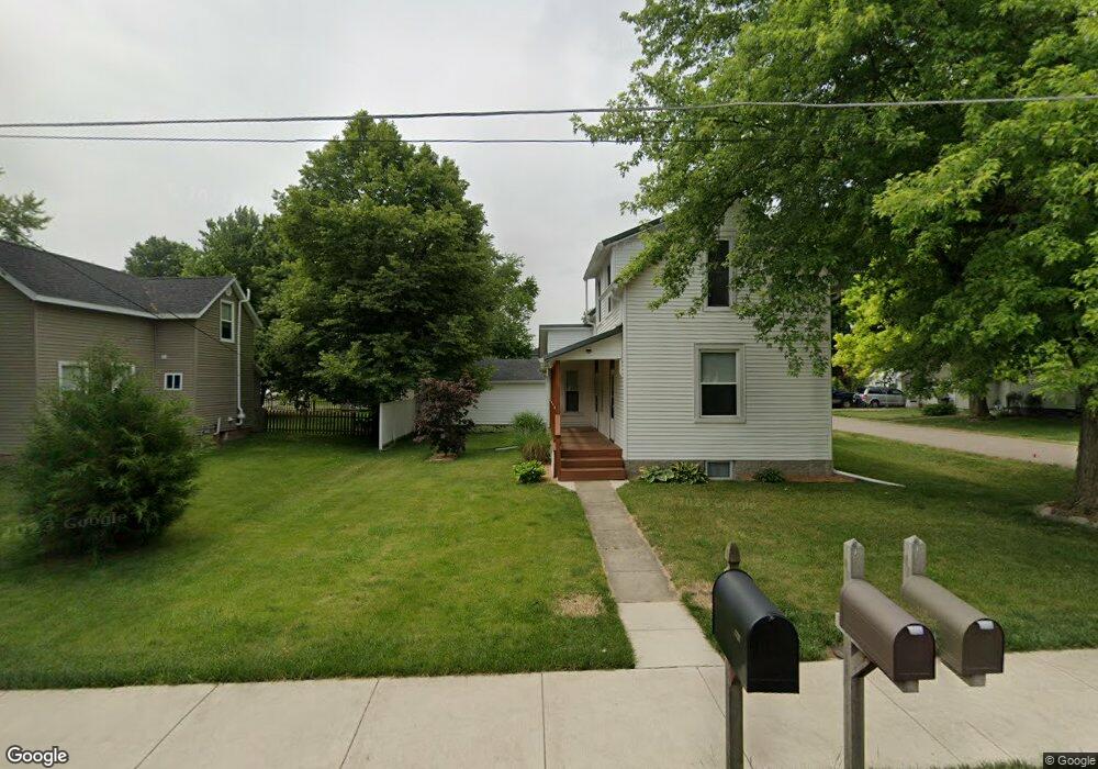
333 W Wyandotte Rd Mulberry, IN 46058
Estimated Value: $209,000 - $247,000
3
Beds
2
Baths
1,192
Sq Ft
$187/Sq Ft
Est. Value
About This Home
This home is located at 333 W Wyandotte Rd, Mulberry, IN 46058 and is currently estimated at $223,065, approximately $187 per square foot. 333 W Wyandotte Rd is a home located in Clinton County with nearby schools including Clinton Prairie Elementary School and Clinton Prairie Junior/Senior High School.
Ownership History
Date
Name
Owned For
Owner Type
Purchase Details
Closed on
Aug 11, 2025
Sold by
Craft Jacob
Bought by
Cook Shelly
Current Estimated Value
Home Financials for this Owner
Home Financials are based on the most recent Mortgage that was taken out on this home.
Original Mortgage
$222,121
Outstanding Balance
$221,739
Interest Rate
6.77%
Mortgage Type
New Conventional
Estimated Equity
$1,326
Purchase Details
Closed on
Apr 27, 2023
Sold by
Patton Robert Troy
Bought by
Craft Jacob M
Home Financials for this Owner
Home Financials are based on the most recent Mortgage that was taken out on this home.
Original Mortgage
$176,777
Interest Rate
6.6%
Mortgage Type
New Conventional
Purchase Details
Closed on
Jan 23, 2015
Sold by
Alsup Tina M
Bought by
Patton Robert Troy
Create a Home Valuation Report for This Property
The Home Valuation Report is an in-depth analysis detailing your home's value as well as a comparison with similar homes in the area
Home Values in the Area
Average Home Value in this Area
Purchase History
| Date | Buyer | Sale Price | Title Company |
|---|---|---|---|
| Cook Shelly | -- | Columbia Title | |
| Craft Jacob M | -- | None Listed On Document | |
| Patton Robert Troy | -- | None Available |
Source: Public Records
Mortgage History
| Date | Status | Borrower | Loan Amount |
|---|---|---|---|
| Open | Cook Shelly | $222,121 | |
| Previous Owner | Craft Jacob M | $176,777 |
Source: Public Records
Tax History Compared to Growth
Tax History
| Year | Tax Paid | Tax Assessment Tax Assessment Total Assessment is a certain percentage of the fair market value that is determined by local assessors to be the total taxable value of land and additions on the property. | Land | Improvement |
|---|---|---|---|---|
| 2024 | $2,002 | $130,200 | $13,200 | $117,000 |
| 2023 | $1,970 | $123,300 | $13,200 | $110,100 |
| 2022 | $1,032 | $123,300 | $13,200 | $110,100 |
| 2021 | $910 | $108,400 | $13,200 | $95,200 |
| 2020 | $661 | $92,800 | $13,200 | $79,600 |
| 2019 | $464 | $79,000 | $13,200 | $65,800 |
| 2018 | $453 | $79,000 | $13,200 | $65,800 |
| 2017 | $496 | $78,700 | $13,200 | $65,500 |
| 2016 | $468 | $74,600 | $11,900 | $62,700 |
| 2014 | $1,528 | $75,700 | $11,900 | $63,800 |
Source: Public Records
Map
Nearby Homes
- 412 W Jackson St
- TBD 38
- 220 E Jackson St
- 504 Funk St
- 500 S Madison St
- 605 E Jackson St
- 0 County Rd 700 W Lot 2 Rd Unit 202519391
- 0 County Rd 700 W Lot 3 Rd Unit 202519392
- 9491 State Route 38
- 10870 E State Road 38
- 6767 W Gas Line Rd
- 5979 State Route 38
- 2928 Mariposa Ln
- 2924 Mariposa Ln
- 2926 Mariposa Ln
- 2922 Mariposa Ln
- 2916 Mariposa Ln
- 2908 Mariposa Ln
- 2914 Mariposa Ln
- 6036 W Turtle Hill Ct
- 327 W Wyandotte Rd
- 332 W Wyandotte Rd
- 328 W Wyandotte Rd
- 317 W Wyandotte Rd
- 54 S Hobson St
- 415 W Wyandotte Rd
- 415 W Wyandotte St
- 404 W Perrin St
- 334 W Perrin St
- 328 W Perrin St
- 322 W Perrin St
- 48 S Hobson St
- 417 W Wyandotte St
- 417 W Wyandotte Rd
- 318 W Perrin St
- 112 S Elm St
- 123 S Willard St
- 424 W Wyandotte Rd
- 106 S Elm St
- 333 W Perrin St