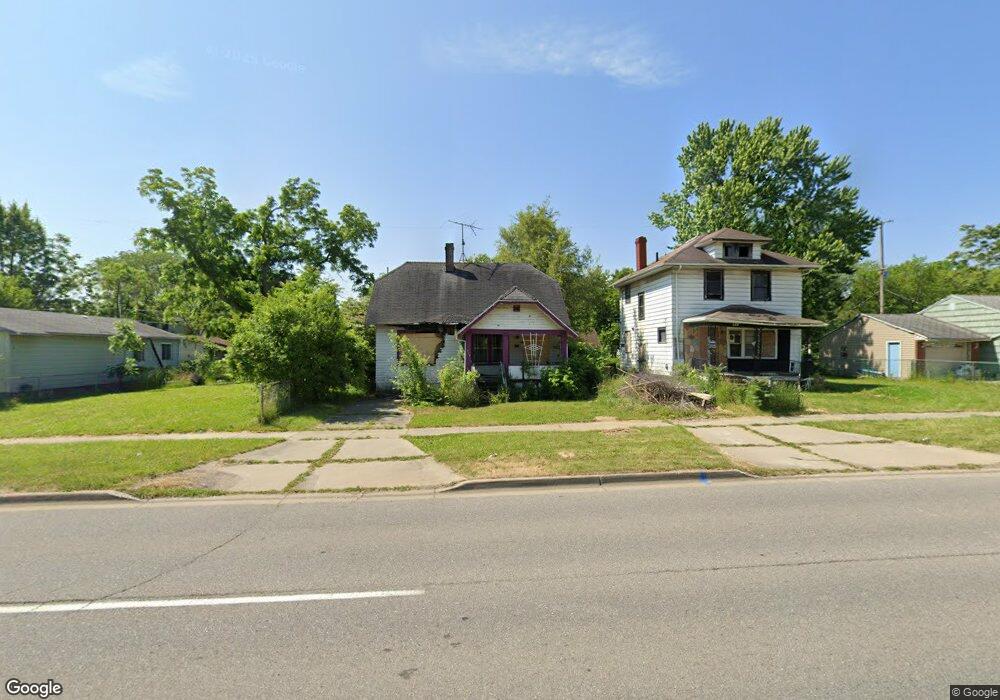
334 E Pierson Rd Flint, MI 48505
King Avenue Plus NeighborhoodEstimated Value: $43,000 - $64,000
3
Beds
1
Bath
910
Sq Ft
$59/Sq Ft
Est. Value
About This Home
This home is located at 334 E Pierson Rd, Flint, MI 48505 and is currently estimated at $53,500, approximately $58 per square foot. 334 E Pierson Rd is a home located in Genesee County with nearby schools including Brownell STEM Academy, The New Standard Academy, and Eagle's Nest Academy.
Ownership History
Date
Name
Owned For
Owner Type
Purchase Details
Closed on
Mar 5, 2018
Sold by
Mcfadden Ruth Ann
Bought by
Williams Trishonda and Williams Thomas
Current Estimated Value
Purchase Details
Closed on
Aug 7, 2006
Sold by
Burns Eugene M
Bought by
Mcfadden Ruth Ann
Purchase Details
Closed on
Aug 3, 2006
Sold by
Burns Robert
Bought by
Mcfadden Ruth Ann
Purchase Details
Closed on
Jul 31, 2006
Sold by
Burns Leroy B
Bought by
Mcfadden Ruth Ann
Purchase Details
Closed on
Jul 25, 2006
Sold by
Burns Lawrence and Burns Armer
Bought by
Mcfadden Ruth Ann
Create a Home Valuation Report for This Property
The Home Valuation Report is an in-depth analysis detailing your home's value as well as a comparison with similar homes in the area
Home Values in the Area
Average Home Value in this Area
Purchase History
| Date | Buyer | Sale Price | Title Company |
|---|---|---|---|
| Williams Trishonda | -- | Cislo Title Co | |
| Mcfadden Ruth Ann | -- | None Available | |
| Mcfadden Ruth Ann | -- | None Available | |
| Mcfadden Ruth Ann | -- | None Available | |
| Mcfadden Ruth Ann | -- | None Available |
Source: Public Records
Tax History
| Year | Tax Paid | Tax Assessment Tax Assessment Total Assessment is a certain percentage of the fair market value that is determined by local assessors to be the total taxable value of land and additions on the property. | Land | Improvement |
|---|---|---|---|---|
| 2025 | -- | $0 | $0 | $0 |
| 2024 | -- | $0 | $0 | $0 |
| 2023 | -- | $0 | $0 | $0 |
| 2022 | $0 | $0 | $0 | $0 |
| 2021 | $0 | $0 | $0 | $0 |
| 2020 | $0 | $0 | $0 | $0 |
| 2019 | $621 | $0 | $0 | $0 |
| 2018 | $598 | $5,400 | $0 | $0 |
| 2017 | $625 | $0 | $0 | $0 |
| 2016 | $621 | $0 | $0 | $0 |
| 2015 | -- | $0 | $0 | $0 |
| 2014 | -- | $0 | $0 | $0 |
| 2012 | -- | $7,900 | $0 | $0 |
Source: Public Records
Map
Nearby Homes
- 350 E Mott Ave
- 205 E Baltimore Blvd
- 618 E Parkway Ave
- 680 E Pierson Rd
- 124 W Flint Park Blvd
- 0 E Marengo Ave Unit 50200980
- 329 W Baltimore Blvd
- 225 E Piper Ave
- 525 W Pulaski Ave
- 510 W Bishop Ave
- 345 E Austin Ave
- 5416 Dupont St
- 702/718 W Flint Park Blvd
- 421 E Lorado Ave
- 425 E Lorado Ave
- 4808 Edwards Ave
- 536 W Home Ave
- 422 E Foss Ave
- 802 E Russell Ave
- 638 E Foss Ave
- 338 E Pierson Rd
- 330 E Pierson Rd
- 342 E Pierson Rd
- 333 E Pulaski Ave
- 322 E Pierson Rd
- 337 E Pulaski Ave
- 329 E Pulaski Ave
- 346 E Pierson Rd
- 341 E Pulaski Ave
- 325 E Pulaski Ave
- 345 E Pulaski Ave
- 321 E Pulaski Ave
- 350 E Pierson Rd
- 318 E Pierson Rd
- 349 E Pulaski Ave
- 317 E Pulaski Ave
- 319 E Pierson Rd
- 314 E Pierson Rd
- 313 E Pierson Rd
- 325 E Pierson Rd
Your Personal Tour Guide
Ask me questions while you tour the home.